![](/images/other/stat-length.png)
![Randonnée Marche Nonsard-Lamarche - Le tour du lac de Madine - Photo](https://media.geolcdn.com/t/1900/400/ext.pjpeg?maxdim=2&url=https%3A%2F%2Fstatic1.geolcdn.com%2Fsiteimages%2Fupload%2Ffiles%2F1553511878bg_sport_marche.png)
Le tour du lac de Madine
joelclaudel
Utilisateur
![Longueur](/images/other/stat-length.png)
Longueur
22 km
![Altitude max](https://static1.geolcdn.com/siteimages/upload/files/1508320355ic_sort_altitude_max_24dp.png)
Altitude max
374 m
![Dénivelé positif](https://static1.geolcdn.com/siteimages/upload/files/1508320355ic_sort_den_pos_24dp.png)
Dénivelé positif
269 m
![Km-Effort](/images/other/stat-length.png)
Km-Effort
26 km
![Altitude min](https://static1.geolcdn.com/siteimages/upload/files/1508320355ic_sort_altitude_min_24dp.png)
Altitude min
221 m
![Dénivelé négatif](https://static1.geolcdn.com/siteimages/upload/files/1508320355ic_sort_den_neg_24dp.png)
Dénivelé négatif
267 m
![Boucle](https://static1.geolcdn.com/siteimages/upload/files/16400158638029165_repeat_loop_refresh_sync_direction_icon.png)
Boucle
Non
Date de création :
2014-12-10 00:00:00.0
Dernière modification :
2014-12-10 00:00:00.0
![Marche](https://static1.geolcdn.com/sitytour/trail-icons/101.png)
5h23
Difficulté : Moyen
![Scannez ce code QR pour ouvrir la randonnée dans l'application SityTrail](https://capi.geolives.com/qq0zvz2zws4bq2lad0pu/sitytour/trails/356196/qr.png?size=200)
Application GPS de randonnée GRATUITE
À propos
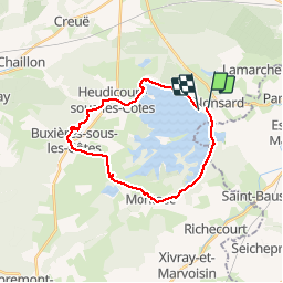
Randonnée Marche de 22 km à découvrir à Grand Est, Meuse, Nonsard-Lamarche. Cette randonnée est proposée par joelclaudel.
Description
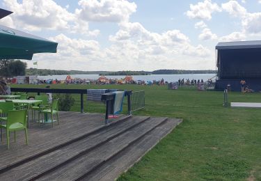
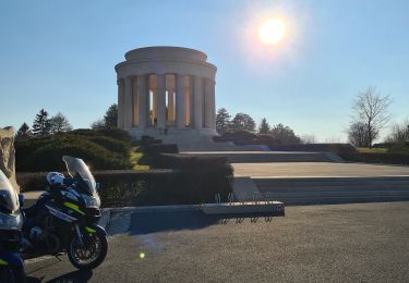
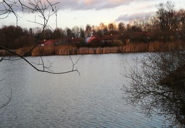
Départ base de loisirs, Montsec, Buxières sous les Côtes, la chapelle des Bures, Heudicourt sous les Côtes, le golf, le port de plaisance et retour base de loisirs.
Localisation
Pays :
France
Région :
Grand Est
Département/Province :
Meuse
Commune :
Nonsard-Lamarche
Localité :
Unknown
Départ:(Dec)
Départ:(UTM)
701849 ; 5423158 (31U) N.
Commentaires
Randonnées à proximité
![Randonnée V.T.T. Nonsard-Lamarche - Chapelle des Bures 2018 V2 - Photo](https://media.geolcdn.com/t/375/260/ext.jpg?maxdim=2&url=https%3A%2F%2Fstatic1.geolcdn.com%2Fsiteimages%2Fupload%2Ffiles%2F1524743154velo.jpg)
![V.T.T. V.T.T.](https://static1.geolcdn.com/sitytour/trail-icons/202.png)
Chapelle des Bures 2018 V2
V.T.T.
Moyen
(1)
Nonsard-Lamarche,
Grand Est,
Meuse,
France
![](/images/other/stat-length.png)
32 km | 39 km-effort
2h 31min
![](https://static1.geolcdn.com/siteimages/upload/files/16400158638029165_repeat_loop_refresh_sync_direction_icon.png)
Oui
![Randonnée V.T.T. Heudicourt-sous-les-Côtes - tour lac de la Madine - Photo](https://media.geolcdn.com/t/375/260/ext.jpg?maxdim=2&url=https%3A%2F%2Fstatic1.geolcdn.com%2Fsiteimages%2Fupload%2Ffiles%2F1524743154velo.jpg)
![V.T.T. V.T.T.](https://static1.geolcdn.com/sitytour/trail-icons/202.png)
tour lac de la Madine
V.T.T.
Facile
(1)
Heudicourt-sous-les-Côtes,
Grand Est,
Meuse,
France
![](/images/other/stat-length.png)
18,1 km | 20 km-effort
1h 15min
![](https://static1.geolcdn.com/siteimages/upload/files/16400158638029165_repeat_loop_refresh_sync_direction_icon.png)
Oui
![Randonnée Marche Nonsard-Lamarche - madine dec 2020 - Photo](https://media.geolcdn.com/t/375/260/2473e464-c97e-4d46-8d24-0e4736694c09.jpg&format=jpg&maxdim=2)
![Marche Marche](https://static1.geolcdn.com/sitytour/trail-icons/101.png)
madine dec 2020
Marche
Très facile
Nonsard-Lamarche,
Grand Est,
Meuse,
France
![](/images/other/stat-length.png)
4,5 km | 4,9 km-effort
16min
![](https://static1.geolcdn.com/siteimages/upload/files/16400158638029165_repeat_loop_refresh_sync_direction_icon.png)
Oui
![Randonnée Marche Nonsard-Lamarche - tout du lac Madine - Photo](https://media.geolcdn.com/t/375/260/f45ecfb4-90a1-49d3-bf0e-86cde9938c59.jpg&format=jpg&maxdim=2)
![Marche Marche](https://static1.geolcdn.com/sitytour/trail-icons/101.png)
tout du lac Madine
Marche
Très facile
Nonsard-Lamarche,
Grand Est,
Meuse,
France
![](/images/other/stat-length.png)
19 km | 21 km-effort
4h 35min
![](https://static1.geolcdn.com/siteimages/upload/files/16400158638029165_repeat_loop_refresh_sync_direction_icon.png)
Oui
![Randonnée Vélo Nonsard-Lamarche - Tour du lac de Madine - Nonsard - Photo](https://media.geolcdn.com/t/375/260/ext.jpg?maxdim=2&url=https%3A%2F%2Fservices.sitytrail.com%2FGeolivesWS%2FDownloadMedia.ashx%3FTrailID%3D112018%26Media%3D9488_5.jpg)
![Vélo Vélo](https://static1.geolcdn.com/sitytour/trail-icons/200.png)
Tour du lac de Madine - Nonsard
Vélo
Moyen
Nonsard-Lamarche,
Grand Est,
Meuse,
France
![](/images/other/stat-length.png)
34 km | 39 km-effort
2h 0min
![](https://static1.geolcdn.com/siteimages/upload/files/16400158638029165_repeat_loop_refresh_sync_direction_icon.png)
Oui
![Randonnée Vélo Nonsard-Lamarche - Autour du Lac de Madine, lecture d'un paysage - Circuit n° 5 - Nonsard - Photo](https://media.geolcdn.com/t/375/260/ext.jpg?maxdim=2&url=https%3A%2F%2Fservices.sitytrail.com%2FGeolivesWS%2FDownloadMedia.ashx%3FTrailID%3D111731%26Media%3D8114_4.jpg)
![Vélo Vélo](https://static1.geolcdn.com/sitytour/trail-icons/200.png)
Autour du Lac de Madine, lecture d'un paysage - Circuit n° 5 - Nonsard
Vélo
Moyen
Nonsard-Lamarche,
Grand Est,
Meuse,
France
![](/images/other/stat-length.png)
33 km | 37 km-effort
1h 45min
![](https://static1.geolcdn.com/siteimages/upload/files/16400158638029165_repeat_loop_refresh_sync_direction_icon.png)
Oui
![Randonnée Vélo électrique Nonsard-Lamarche - lac de la Madine et Monsec - Photo](https://media.geolcdn.com/t/375/260/c2874552-2108-4cfc-b02b-03de011bd24f.jpg&format=jpg&maxdim=2)
![Vélo électrique Vélo électrique](https://static1.geolcdn.com/sitytour/trail-icons/205.png)
lac de la Madine et Monsec
Vélo électrique
Très facile
Nonsard-Lamarche,
Grand Est,
Meuse,
France
![](/images/other/stat-length.png)
24 km | 28 km-effort
1h 30min
![](https://static1.geolcdn.com/siteimages/upload/files/16400158638029165_repeat_loop_refresh_sync_direction_icon.png)
Oui
![Randonnée Marche Nonsard-Lamarche - lac de Madine - Photo](https://media.geolcdn.com/t/375/260/78cac4d3-ad5b-41db-900a-7d33d9766369.jpeg&format=jpg&maxdim=2)
![Marche Marche](https://static1.geolcdn.com/sitytour/trail-icons/101.png)
lac de Madine
Marche
Difficile
Nonsard-Lamarche,
Grand Est,
Meuse,
France
![](/images/other/stat-length.png)
12,9 km | 13,8 km-effort
5h 7min
![](https://static1.geolcdn.com/siteimages/upload/files/16400158638029165_repeat_loop_refresh_sync_direction_icon.png)
Oui
![Randonnée Marche Heudicourt-sous-les-Côtes - madine heudicourt - Photo](https://media.geolcdn.com/t/375/260/5b4c8aca-6394-447a-a3ac-76221db7278d.jpg&format=jpg&maxdim=2)
![Marche Marche](https://static1.geolcdn.com/sitytour/trail-icons/101.png)
madine heudicourt
Marche
Très facile
Heudicourt-sous-les-Côtes,
Grand Est,
Meuse,
France
![](/images/other/stat-length.png)
3,5 km | 3,7 km-effort
51min
![](https://static1.geolcdn.com/siteimages/upload/files/16400158638029165_repeat_loop_refresh_sync_direction_icon.png)
Non