![](/images/other/stat-length.png)
![Randonnée Marche Saint-Aubin-lès-Elbeuf - à la découverte de saint aubin les elbeuf - Photo](https://media.geolcdn.com/t/1900/400/ext.pjpeg?maxdim=2&url=https%3A%2F%2Fstatic1.geolcdn.com%2Fsiteimages%2Fupload%2Ffiles%2F1553511878bg_sport_marche.png)
à la découverte de saint aubin les elbeuf
nicole.reine@wanadoo.fr
Utilisateur
![Longueur](/images/other/stat-length.png)
Longueur
5,5 km
![Altitude max](https://static1.geolcdn.com/siteimages/upload/files/1508320355ic_sort_altitude_max_24dp.png)
Altitude max
34 m
![Dénivelé positif](https://static1.geolcdn.com/siteimages/upload/files/1508320355ic_sort_den_pos_24dp.png)
Dénivelé positif
55 m
![Km-Effort](/images/other/stat-length.png)
Km-Effort
6,3 km
![Altitude min](https://static1.geolcdn.com/siteimages/upload/files/1508320355ic_sort_altitude_min_24dp.png)
Altitude min
3 m
![Dénivelé négatif](https://static1.geolcdn.com/siteimages/upload/files/1508320355ic_sort_den_neg_24dp.png)
Dénivelé négatif
55 m
![Boucle](https://static1.geolcdn.com/siteimages/upload/files/16400158638029165_repeat_loop_refresh_sync_direction_icon.png)
Boucle
Oui
Date de création :
2023-02-22 17:31:37.751
Dernière modification :
2023-02-22 17:36:55.481
![Marche](https://static1.geolcdn.com/sitytour/trail-icons/101.png)
1h25
Difficulté : Moyen
![Scannez ce code QR pour ouvrir la randonnée dans l'application SityTrail](https://capi.geolives.com/qq0zvz2zws4bq2lad0pu/sitytour/trails/3561715/qr.png?size=200)
Application GPS de randonnée GRATUITE
À propos
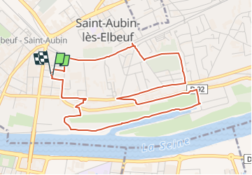
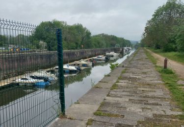
Randonnée Marche de 5,5 km à découvrir à Normandie, Seine-Maritime, Saint-Aubin-lès-Elbeuf. Cette randonnée est proposée par nicole.reine@wanadoo.fr.
Description
départ de l'esplanade de pattensen place de l’hôtel de ville
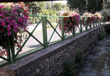
Plaquette du circuit vert avec descriptifs sur le site de la commune
Localisation
Pays :
France
Région :
Normandie
Département/Province :
Seine-Maritime
Commune :
Saint-Aubin-lès-Elbeuf
Localité :
Unknown
Départ:(Dec)
Départ:(UTM)
355543 ; 5462603 (31U) N.
Commentaires
Randonnées à proximité
![Randonnée Marche Caudebec-lès-Elbeuf - Caudebec-les- Elbeuf 12km - Photo](https://media.geolcdn.com/t/375/260/ff911e05-9d04-4aef-af60-0d3d13a09c7b.jpg&format=jpg&maxdim=2)
![Marche Marche](https://static1.geolcdn.com/sitytour/trail-icons/101.png)
Caudebec-les- Elbeuf 12km
Marche
Moyen
(1)
Caudebec-lès-Elbeuf,
Normandie,
Seine-Maritime,
France
![](/images/other/stat-length.png)
10,7 km | 13,8 km-effort
3h 56min
![](https://static1.geolcdn.com/siteimages/upload/files/16400158638029165_repeat_loop_refresh_sync_direction_icon.png)
Oui
![Randonnée Marche La Londe - La Londe 76- 13 km - Photo](https://media.geolcdn.com/t/375/260/23588b19-2689-475f-b2bd-10608cbf7253.jpg&format=jpg&maxdim=2)
![Marche Marche](https://static1.geolcdn.com/sitytour/trail-icons/101.png)
La Londe 76- 13 km
Marche
Difficile
(1)
La Londe,
Normandie,
Seine-Maritime,
France
![](/images/other/stat-length.png)
13 km | 16,1 km-effort
3h 43min
![](https://static1.geolcdn.com/siteimages/upload/files/16400158638029165_repeat_loop_refresh_sync_direction_icon.png)
Oui
![Randonnée Marche Caudebec-lès-Elbeuf - Caudebec les Elbeuf vers saint Cyr la campagne - Photo](https://media.geolcdn.com/t/375/260/ext.jpg?maxdim=2&url=https%3A%2F%2Fservices.sitytrail.com%2FGeolivesWS%2FDownloadMedia.ashx%3FTrailID%3D985245%26Media%3Dfix__20180531102544.jpg)
![Marche Marche](https://static1.geolcdn.com/sitytour/trail-icons/101.png)
Caudebec les Elbeuf vers saint Cyr la campagne
Marche
Moyen
(2)
Caudebec-lès-Elbeuf,
Normandie,
Seine-Maritime,
France
![](/images/other/stat-length.png)
12 km | 15,2 km-effort
3h 7min
![](https://static1.geolcdn.com/siteimages/upload/files/16400158638029165_repeat_loop_refresh_sync_direction_icon.png)
Oui
![Randonnée V.T.T. Caudebec-lès-Elbeuf - La Caudebécaise 2011 - 45 km - Caudebec-lès-Elbeuf - Photo](https://media.geolcdn.com/t/375/260/ext.jpg?maxdim=2&url=https%3A%2F%2Fservices.sitytrail.com%2FGeolivesWS%2FDownloadMedia.ashx%3FTrailID%3D106431%26Media%3D10925_1.jpg)
![V.T.T. V.T.T.](https://static1.geolcdn.com/sitytour/trail-icons/202.png)
La Caudebécaise 2011 - 45 km - Caudebec-lès-Elbeuf
V.T.T.
Difficile
(1)
Caudebec-lès-Elbeuf,
Normandie,
Seine-Maritime,
France
![](/images/other/stat-length.png)
43 km | 54 km-effort
3h 0min
![](https://static1.geolcdn.com/siteimages/upload/files/16400158638029165_repeat_loop_refresh_sync_direction_icon.png)
Oui
![Randonnée Marche Moulineaux - Robert-le-Diable - château - GD - V2 - Photo](https://media.geolcdn.com/t/375/260/ext.jpg?maxdim=2&url=https%3A%2F%2Fstatic1.geolcdn.com%2Fsiteimages%2Fupload%2Ffiles%2F1553511878bg_sport_marche.png)
![Marche Marche](https://static1.geolcdn.com/sitytour/trail-icons/101.png)
Robert-le-Diable - château - GD - V2
Marche
Difficile
(1)
Moulineaux,
Normandie,
Seine-Maritime,
France
![](/images/other/stat-length.png)
10,4 km | 13,1 km-effort
2h 58min
![](https://static1.geolcdn.com/siteimages/upload/files/16400158638029165_repeat_loop_refresh_sync_direction_icon.png)
Oui
![Randonnée Marche Cléon - 20200120-Cléon COOL - Photo](https://media.geolcdn.com/t/375/260/ext.jpg?maxdim=2&url=https%3A%2F%2Fstatic1.geolcdn.com%2Fsiteimages%2Fupload%2Ffiles%2F1553511878bg_sport_marche.png)
![Marche Marche](https://static1.geolcdn.com/sitytour/trail-icons/101.png)
20200120-Cléon COOL
Marche
Facile
(2)
Cléon,
Normandie,
Seine-Maritime,
France
![](/images/other/stat-length.png)
8,8 km | 9,4 km-effort
2h 10min
![](https://static1.geolcdn.com/siteimages/upload/files/16400158638029165_repeat_loop_refresh_sync_direction_icon.png)
Oui
![Marche Marche](https://static1.geolcdn.com/sitytour/trail-icons/101.png)
20240903-Martot -Cool
Marche
Facile
Martot,
Normandie,
Eure,
France
![](/images/other/stat-length.png)
7,5 km | 8,4 km-effort
2h 9min
![](https://static1.geolcdn.com/siteimages/upload/files/16400158638029165_repeat_loop_refresh_sync_direction_icon.png)
Oui
![Randonnée Marche Saint-Pierre-lès-Elbeuf - orival les troglodyte - Photo](https://media.geolcdn.com/t/375/260/92f6efdc-352c-4a72-a8db-32871db4d1d7.jpg&format=jpg&maxdim=2)
![Marche Marche](https://static1.geolcdn.com/sitytour/trail-icons/101.png)
orival les troglodyte
Marche
Moyen
Saint-Pierre-lès-Elbeuf,
Normandie,
Seine-Maritime,
France
![](/images/other/stat-length.png)
11,2 km | 14,9 km-effort
1h 40min
![](https://static1.geolcdn.com/siteimages/upload/files/16400158638029165_repeat_loop_refresh_sync_direction_icon.png)
Non
![Randonnée Marche Elbeuf - elbeuf/chemin du halage - Photo](https://media.geolcdn.com/t/375/260/538ff371-2c24-4bd6-b0ae-2b3d8c404d65.jpg&format=jpg&maxdim=2)
![Marche Marche](https://static1.geolcdn.com/sitytour/trail-icons/101.png)
elbeuf/chemin du halage
Marche
Très facile
(1)
Elbeuf,
Normandie,
Seine-Maritime,
France
![](/images/other/stat-length.png)
7,9 km | 8,6 km-effort
1h 35min
![](https://static1.geolcdn.com/siteimages/upload/files/16400158638029165_repeat_loop_refresh_sync_direction_icon.png)
Oui