![](/images/other/stat-length.png)
![Randonnée Marche Brissac - notre Dame du suc - Photo](https://media.geolcdn.com/t/1900/400/ext.pjpeg?maxdim=2&url=https%3A%2F%2Fstatic1.geolcdn.com%2Fsiteimages%2Fupload%2Ffiles%2F1553511878bg_sport_marche.png)
notre Dame du suc
labarone
Utilisateur
![Longueur](/images/other/stat-length.png)
Longueur
17,2 km
![Altitude max](https://static1.geolcdn.com/siteimages/upload/files/1508320355ic_sort_altitude_max_24dp.png)
Altitude max
910 m
![Dénivelé positif](https://static1.geolcdn.com/siteimages/upload/files/1508320355ic_sort_den_pos_24dp.png)
Dénivelé positif
766 m
![Km-Effort](/images/other/stat-length.png)
Km-Effort
27 km
![Altitude min](https://static1.geolcdn.com/siteimages/upload/files/1508320355ic_sort_altitude_min_24dp.png)
Altitude min
147 m
![Dénivelé négatif](https://static1.geolcdn.com/siteimages/upload/files/1508320355ic_sort_den_neg_24dp.png)
Dénivelé négatif
768 m
![Boucle](https://static1.geolcdn.com/siteimages/upload/files/16400158638029165_repeat_loop_refresh_sync_direction_icon.png)
Boucle
Oui
Date de création :
2023-02-21 08:00:53.259
Dernière modification :
2023-02-21 14:42:10.96
![Marche](https://static1.geolcdn.com/sitytour/trail-icons/101.png)
6h02
Difficulté : Difficile
![Scannez ce code QR pour ouvrir la randonnée dans l'application SityTrail](https://capi.geolives.com/qq0zvz2zws4bq2lad0pu/sitytour/trails/3560162/qr.png?size=200)
Application GPS de randonnée GRATUITE
À propos
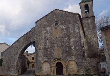
Randonnée Marche de 17,2 km à découvrir à Occitanie, Hérault, Brissac. Cette randonnée est proposée par labarone.
Description
sacré côté caillouteuse (3 pas en avant et 1 en arrière !) A faire si pas trop chaud. Belle vue a partir du Roc blanc sur la Seranne ...
Localisation
Pays :
France
Région :
Occitanie
Département/Province :
Hérault
Commune :
Brissac
Localité :
Unknown
Départ:(Dec)
Départ:(UTM)
554709 ; 4857411 (31T) N.
Commentaires
Randonnées à proximité
![Randonnée Marche Saint-Bauzille-de-Putois - st bauzille de putois plus bord herault - Photo](https://media.geolcdn.com/t/375/260/ext.jpg?maxdim=2&url=https%3A%2F%2Fstatic1.geolcdn.com%2Fsiteimages%2Fupload%2Ffiles%2F1553511878bg_sport_marche.png)
![Marche Marche](https://static1.geolcdn.com/sitytour/trail-icons/101.png)
st bauzille de putois plus bord herault
Marche
Facile
(3)
Saint-Bauzille-de-Putois,
Occitanie,
Hérault,
France
![](/images/other/stat-length.png)
7 km | 8,8 km-effort
1h 59min
![](https://static1.geolcdn.com/siteimages/upload/files/16400158638029165_repeat_loop_refresh_sync_direction_icon.png)
Oui
![Randonnée Marche Brissac - Brissac à Croix Ste Micisse - Photo](https://media.geolcdn.com/t/375/260/59e2c1f3-52eb-417b-9103-ff63004fd457.jpg&format=jpg&maxdim=2)
![Marche Marche](https://static1.geolcdn.com/sitytour/trail-icons/101.png)
Brissac à Croix Ste Micisse
Marche
Moyen
Brissac,
Occitanie,
Hérault,
France
![](/images/other/stat-length.png)
19,8 km | 28 km-effort
6h 1min
![](https://static1.geolcdn.com/siteimages/upload/files/16400158638029165_repeat_loop_refresh_sync_direction_icon.png)
Oui
![Randonnée Marche Brissac - 34 brissac - Photo](https://media.geolcdn.com/t/375/260/60cabbc4-5250-488d-a0c0-023fee13261d.jpg&format=jpg&maxdim=2)
![Marche Marche](https://static1.geolcdn.com/sitytour/trail-icons/101.png)
![Randonnée Marche Brissac - Brissac - abime Rabanel - Roc Blanc - Notre-Dame-du-Suc - Photo](https://media.geolcdn.com/t/375/260/ext.jpg?maxdim=2&url=https%3A%2F%2Fstatic1.geolcdn.com%2Fsiteimages%2Fupload%2Ffiles%2F1553511878bg_sport_marche.png)
![Marche Marche](https://static1.geolcdn.com/sitytour/trail-icons/101.png)
Brissac - abime Rabanel - Roc Blanc - Notre-Dame-du-Suc
Marche
Moyen
(1)
Brissac,
Occitanie,
Hérault,
France
![](/images/other/stat-length.png)
18,2 km | 29 km-effort
6h 7min
![](https://static1.geolcdn.com/siteimages/upload/files/16400158638029165_repeat_loop_refresh_sync_direction_icon.png)
Oui
![Randonnée Marche Brissac - autour de Brissac - Photo](https://media.geolcdn.com/t/375/260/ext.jpg?maxdim=2&url=https%3A%2F%2Fstatic1.geolcdn.com%2Fsiteimages%2Fupload%2Ffiles%2F1553511878bg_sport_marche.png)
![Marche Marche](https://static1.geolcdn.com/sitytour/trail-icons/101.png)
autour de Brissac
Marche
Difficile
(2)
Brissac,
Occitanie,
Hérault,
France
![](/images/other/stat-length.png)
20 km | 33 km-effort
6h 42min
![](https://static1.geolcdn.com/siteimages/upload/files/16400158638029165_repeat_loop_refresh_sync_direction_icon.png)
Oui
![Randonnée Marche Brissac - camping - Photo](https://media.geolcdn.com/t/375/260/ext.jpg?maxdim=2&url=https%3A%2F%2Fstatic1.geolcdn.com%2Fsiteimages%2Fupload%2Ffiles%2F1553511878bg_sport_marche.png)
![Marche Marche](https://static1.geolcdn.com/sitytour/trail-icons/101.png)
![Randonnée Marche Brissac - Brissac, ND du Suc, Papeterie - Photo](https://media.geolcdn.com/t/375/260/ec2e77c9-6145-40a7-84ea-5c5a7ac5c9ab.jpg&format=jpg&maxdim=2)
![Marche Marche](https://static1.geolcdn.com/sitytour/trail-icons/101.png)
Brissac, ND du Suc, Papeterie
Marche
Moyen
Brissac,
Occitanie,
Hérault,
France
![](/images/other/stat-length.png)
8,9 km | 12,5 km-effort
2h 50min
![](https://static1.geolcdn.com/siteimages/upload/files/16400158638029165_repeat_loop_refresh_sync_direction_icon.png)
Oui
![Randonnée A pied Brissac - BRISSAC- les trois termes aller retour - Photo](https://media.geolcdn.com/t/375/260/007e983e-6bab-4a06-be51-05d6cb6a7218.jpg&format=jpg&maxdim=2)
![A pied A pied](https://static1.geolcdn.com/sitytour/trail-icons/100.png)
BRISSAC- les trois termes aller retour
A pied
Moyen
Brissac,
Occitanie,
Hérault,
France
![](/images/other/stat-length.png)
18 km | 28 km-effort
6h 21min
![](https://static1.geolcdn.com/siteimages/upload/files/16400158638029165_repeat_loop_refresh_sync_direction_icon.png)
Oui
![Randonnée Marche Brissac - Roc blanc - Photo](https://media.geolcdn.com/t/375/260/652f63e7-6763-4b38-8477-21981eb86686.jpg&format=jpg&maxdim=2)
![Marche Marche](https://static1.geolcdn.com/sitytour/trail-icons/101.png)