![](/images/other/stat-length.png)
![Randonnée Marche Monestier-d'Ambel - Pas de Larche Pierroux - Photo](https://media.geolcdn.com/t/1900/400/ext.pjpeg?maxdim=2&url=https%3A%2F%2Fstatic1.geolcdn.com%2Fsiteimages%2Fupload%2Ffiles%2F1553511878bg_sport_marche.png)
Pas de Larche Pierroux
GAPIAN43
Utilisateur
![Longueur](/images/other/stat-length.png)
Longueur
14,3 km
![Altitude max](https://static1.geolcdn.com/siteimages/upload/files/1508320355ic_sort_altitude_max_24dp.png)
Altitude max
2355 m
![Dénivelé positif](https://static1.geolcdn.com/siteimages/upload/files/1508320355ic_sort_den_pos_24dp.png)
Dénivelé positif
1582 m
![Km-Effort](/images/other/stat-length.png)
Km-Effort
35 km
![Altitude min](https://static1.geolcdn.com/siteimages/upload/files/1508320355ic_sort_altitude_min_24dp.png)
Altitude min
952 m
![Dénivelé négatif](https://static1.geolcdn.com/siteimages/upload/files/1508320355ic_sort_den_neg_24dp.png)
Dénivelé négatif
1583 m
![Boucle](https://static1.geolcdn.com/siteimages/upload/files/16400158638029165_repeat_loop_refresh_sync_direction_icon.png)
Boucle
Oui
Date de création :
2017-08-06 00:00:00.0
Dernière modification :
2020-05-10 18:28:47.356
![Marche](https://static1.geolcdn.com/sitytour/trail-icons/101.png)
7h01
Difficulté : Très difficile
![Scannez ce code QR pour ouvrir la randonnée dans l'application SityTrail](https://capi.geolives.com/qq0zvz2zws4bq2lad0pu/sitytour/trails/356010/qr.png?size=200)
Application GPS de randonnée GRATUITE
À propos
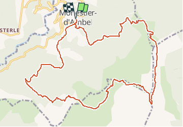
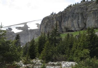
Randonnée Marche de 14,3 km à découvrir à Auvergne-Rhône-Alpes, Isère, Monestier-d'Ambel. Cette randonnée est proposée par GAPIAN43.
Description
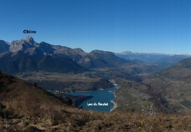
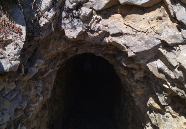
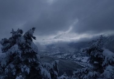
http://data.over-blog-kiwi.com/1/37/27/34/20150602/ob_d8e736_la-grande-vire-du-pierroux.pdf
Les photos :
https://picasaweb.google.com/110539922854627498228/20150523PasDeLarchePierroux?feat=directlink
Localisation
Pays :
France
Région :
Auvergne-Rhône-Alpes
Département/Province :
Isère
Commune :
Monestier-d'Ambel
Localité :
Unknown
Départ:(Dec)
Départ:(UTM)
731529 ; 4962447 (31T) N.
Commentaires
Randonnées à proximité
![Randonnée Marche Aspres-lès-Corps - Aspres les corps - Roche Courbe - Photo](https://media.geolcdn.com/t/375/260/ext.jpg?maxdim=2&url=https%3A%2F%2Fservices.sitytrail.com%2FGeolivesWS%2FDownloadMedia.ashx%3FTrailID%3D655638%26Media%3Dd468d5e8-71c8-44e5-98f2-217554c35ba5.JPG)
![Marche Marche](https://static1.geolcdn.com/sitytour/trail-icons/101.png)
Aspres les corps - Roche Courbe
Marche
Très difficile
(1)
Aspres-lès-Corps,
Provence-Alpes-Côte d'Azur,
Hautes-Alpes,
France
![](/images/other/stat-length.png)
10,6 km | 24 km-effort
4h 53min
![](https://static1.geolcdn.com/siteimages/upload/files/16400158638029165_repeat_loop_refresh_sync_direction_icon.png)
Oui
![Randonnée Marche Le Dévoluy - Pierre Baudinard - Photo](https://media.geolcdn.com/t/375/260/dea0799c-94e0-4315-9166-bde984af0e12.jpg&format=jpg&maxdim=2)
![Marche Marche](https://static1.geolcdn.com/sitytour/trail-icons/101.png)
Pierre Baudinard
Marche
Difficile
Le Dévoluy,
Provence-Alpes-Côte d'Azur,
Hautes-Alpes,
France
![](/images/other/stat-length.png)
11 km | 19,6 km-effort
4h 27min
![](https://static1.geolcdn.com/siteimages/upload/files/16400158638029165_repeat_loop_refresh_sync_direction_icon.png)
Oui
![Randonnée Marche Pellafol - 38 source gaillarde internet ch fée - Photo](https://media.geolcdn.com/t/375/260/34314d4b-0476-4e34-bbdb-55d6e7cd37b0.jpg&format=jpg&maxdim=2)
![Marche Marche](https://static1.geolcdn.com/sitytour/trail-icons/101.png)
38 source gaillarde internet ch fée
Marche
Moyen
Pellafol,
Auvergne-Rhône-Alpes,
Isère,
France
![](/images/other/stat-length.png)
13,3 km | 19,9 km-effort
6h 32min
![](https://static1.geolcdn.com/siteimages/upload/files/16400158638029165_repeat_loop_refresh_sync_direction_icon.png)
Non
![Randonnée Ski de randonnée Aspres-lès-Corps - tentative du Laton, pic gazonné - Photo](https://media.geolcdn.com/t/375/260/bb214dca-e6e7-4564-b147-bec3a550b510.jpg&format=jpg&maxdim=2)
![Ski de randonnée Ski de randonnée](https://static1.geolcdn.com/sitytour/trail-icons/503.png)
tentative du Laton, pic gazonné
Ski de randonnée
Facile
Aspres-lès-Corps,
Provence-Alpes-Côte d'Azur,
Hautes-Alpes,
France
![](/images/other/stat-length.png)
6,9 km | 15,9 km-effort
4h 36min
![](https://static1.geolcdn.com/siteimages/upload/files/16400158638029165_repeat_loop_refresh_sync_direction_icon.png)
Oui
![Randonnée Marche Le Dévoluy - Le Faraut. Pic pierroux - Photo](https://media.geolcdn.com/t/375/260/f70077a3-127b-4a4c-a1bb-36cf90d608f0.jpg&format=jpg&maxdim=2)
![Marche Marche](https://static1.geolcdn.com/sitytour/trail-icons/101.png)
Le Faraut. Pic pierroux
Marche
Moyen
Le Dévoluy,
Provence-Alpes-Côte d'Azur,
Hautes-Alpes,
France
![](/images/other/stat-length.png)
10,3 km | 25 km-effort
7h 10min
![](https://static1.geolcdn.com/siteimages/upload/files/16400158638029165_repeat_loop_refresh_sync_direction_icon.png)
Oui
![Randonnée Marche Pellafol - R44 Le Bénitier - Photo](https://media.geolcdn.com/t/375/260/c09c5294-f23e-4ece-8780-88830b0ef2c5.jpg&format=jpg&maxdim=2)
![Marche Marche](https://static1.geolcdn.com/sitytour/trail-icons/101.png)
R44 Le Bénitier
Marche
Moyen
(1)
Pellafol,
Auvergne-Rhône-Alpes,
Isère,
France
![](/images/other/stat-length.png)
14 km | 25 km-effort
3h 0min
![](https://static1.geolcdn.com/siteimages/upload/files/16400158638029165_repeat_loop_refresh_sync_direction_icon.png)
Oui
![Randonnée Marche Pellafol - R43 Les Gillardes et Le Canyon de l'Infernet de Pellafol - Photo](https://media.geolcdn.com/t/375/260/ext.jpg?maxdim=2&url=https%3A%2F%2Fservices.sitytrail.com%2FGeolivesWS%2FDownloadMedia.ashx%3FTrailID%3D890901%26Media%3D34932a86-a06f-4702-8669-5c5d0130cca7.jpg)
![Marche Marche](https://static1.geolcdn.com/sitytour/trail-icons/101.png)
R43 Les Gillardes et Le Canyon de l'Infernet de Pellafol
Marche
Très facile
(2)
Pellafol,
Auvergne-Rhône-Alpes,
Isère,
France
![](/images/other/stat-length.png)
6,1 km | 8,5 km-effort
1h 48min
![](https://static1.geolcdn.com/siteimages/upload/files/16400158638029165_repeat_loop_refresh_sync_direction_icon.png)
Oui
![Randonnée Marche Le Dévoluy - R30 Le Puits des Bans - Photo](https://media.geolcdn.com/t/375/260/ext.jpg?maxdim=2&url=https%3A%2F%2Fservices.sitytrail.com%2FGeolivesWS%2FDownloadMedia.ashx%3FTrailID%3D890889%26Media%3Df7b1d6b4-ea22-4c01-9d63-d59f6ee8ceaf.jpg)
![Marche Marche](https://static1.geolcdn.com/sitytour/trail-icons/101.png)
R30 Le Puits des Bans
Marche
Facile
(2)
Le Dévoluy,
Provence-Alpes-Côte d'Azur,
Hautes-Alpes,
France
![](/images/other/stat-length.png)
5,2 km | 6,4 km-effort
3h 8min
![](https://static1.geolcdn.com/siteimages/upload/files/16400158638029165_repeat_loop_refresh_sync_direction_icon.png)
Oui
![Randonnée Marche Le Dévoluy - R25 Pierre Baudinard - Photo](https://media.geolcdn.com/t/375/260/ext.jpg?maxdim=2&url=https%3A%2F%2Fservices.sitytrail.com%2FGeolivesWS%2FDownloadMedia.ashx%3FTrailID%3D890883%26Media%3Dee7710be-21b7-48d4-afcd-1270ef050a11.jpg)
![Marche Marche](https://static1.geolcdn.com/sitytour/trail-icons/101.png)
R25 Pierre Baudinard
Marche
Moyen
(1)
Le Dévoluy,
Provence-Alpes-Côte d'Azur,
Hautes-Alpes,
France
![](/images/other/stat-length.png)
8,6 km | 16,6 km-effort
3h 18min
![](https://static1.geolcdn.com/siteimages/upload/files/16400158638029165_repeat_loop_refresh_sync_direction_icon.png)
Oui