![](/images/other/stat-length.png)
![Randonnée Raquettes à neige Chapelle-des-Bois - Chapelle-des-Bois - La Grotte - Photo](https://media.geolcdn.com/t/1900/400/ext.pjpeg?maxdim=2&url=https%3A%2F%2Fstatic1.geolcdn.com%2Fsiteimages%2Fupload%2Ffiles%2F1524743153raquette.jpg)
Chapelle-des-Bois - La Grotte
danielf
Utilisateur
![Longueur](/images/other/stat-length.png)
Longueur
10,7 km
![Altitude max](https://static1.geolcdn.com/siteimages/upload/files/1508320355ic_sort_altitude_max_24dp.png)
Altitude max
1148 m
![Dénivelé positif](https://static1.geolcdn.com/siteimages/upload/files/1508320355ic_sort_den_pos_24dp.png)
Dénivelé positif
214 m
![Km-Effort](/images/other/stat-length.png)
Km-Effort
13,6 km
![Altitude min](https://static1.geolcdn.com/siteimages/upload/files/1508320355ic_sort_altitude_min_24dp.png)
Altitude min
1051 m
![Dénivelé négatif](https://static1.geolcdn.com/siteimages/upload/files/1508320355ic_sort_den_neg_24dp.png)
Dénivelé négatif
214 m
![Boucle](https://static1.geolcdn.com/siteimages/upload/files/16400158638029165_repeat_loop_refresh_sync_direction_icon.png)
Boucle
Oui
Date de création :
2023-02-14 23:03:40.82
Dernière modification :
2023-02-15 20:25:53.17
![Raquettes à neige](https://static1.geolcdn.com/sitytour/trail-icons/504.png)
4h12
Difficulté : Facile
![Scannez ce code QR pour ouvrir la randonnée dans l'application SityTrail](https://capi.geolives.com/qq0zvz2zws4bq2lad0pu/sitytour/trails/3552427/qr.png?size=200)
Application GPS de randonnée GRATUITE
À propos
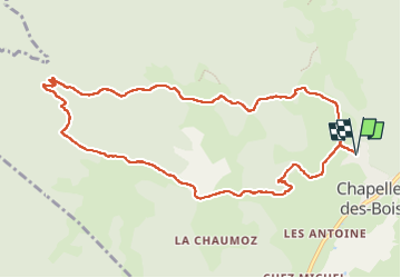
Randonnée Raquettes à neige de 10,7 km à découvrir à Bourgogne-Franche-Comté, Doubs, Chapelle-des-Bois. Cette randonnée est proposée par danielf.
Description
Piste raquettes W "La Grotte" avec petite variante.
Pass balade nécessaire.
Cet itinéraire vous est offert gracieusement par info randonnée - https://www.autre-chemin.be
Localisation
Pays :
France
Région :
Bourgogne-Franche-Comté
Département/Province :
Doubs
Commune :
Chapelle-des-Bois
Localité :
Unknown
Départ:(Dec)
Départ:(UTM)
278868 ; 5165104 (32T) N.
Commentaires
Randonnées à proximité
![Randonnée Marche Chapelle-des-Bois - roche Bernard - Photo](https://media.geolcdn.com/t/375/260/ext.jpg?maxdim=2&url=https%3A%2F%2Fservices.sitytrail.com%2FGeolivesWS%2FDownloadMedia.ashx%3FTrailID%3D314677%26Media%3D20140620142657.jpg)
![Marche Marche](https://static1.geolcdn.com/sitytour/trail-icons/101.png)
roche Bernard
Marche
Moyen
(1)
Chapelle-des-Bois,
Bourgogne-Franche-Comté,
Doubs,
France
![](/images/other/stat-length.png)
15 km | 21 km-effort
4h 33min
![](https://static1.geolcdn.com/siteimages/upload/files/16400158638029165_repeat_loop_refresh_sync_direction_icon.png)
Oui
![Randonnée Marche Chapelle-des-Bois - ROCHE CHAMPION - Photo](https://media.geolcdn.com/t/375/260/ext.jpg?maxdim=2&url=https%3A%2F%2Fservices.sitytrail.com%2FGeolivesWS%2FDownloadMedia.ashx%3FTrailID%3D357205%26Media%3Dfix__20141026130524.jpg)
![Marche Marche](https://static1.geolcdn.com/sitytour/trail-icons/101.png)
ROCHE CHAMPION
Marche
Facile
(2)
Chapelle-des-Bois,
Bourgogne-Franche-Comté,
Doubs,
France
![](/images/other/stat-length.png)
8,6 km | 13,6 km-effort
1h 50min
![](https://static1.geolcdn.com/siteimages/upload/files/16400158638029165_repeat_loop_refresh_sync_direction_icon.png)
Oui
![Randonnée Marche Bellefontaine - Lac de Bellefontaine er lac des Mortes . - Photo](https://media.geolcdn.com/t/375/260/7671d781-54af-47e4-b735-a1a3fd8960ba.jpg&format=jpg&maxdim=2)
![Marche Marche](https://static1.geolcdn.com/sitytour/trail-icons/101.png)
Lac de Bellefontaine er lac des Mortes .
Marche
Facile
Bellefontaine,
Bourgogne-Franche-Comté,
Jura,
France
![](/images/other/stat-length.png)
9,5 km | 11,5 km-effort
2h 33min
![](https://static1.geolcdn.com/siteimages/upload/files/16400158638029165_repeat_loop_refresh_sync_direction_icon.png)
Oui
![Randonnée Marche Chapelle-des-Bois - Roche Champion et Bernard 11.7.24 - Photo](https://media.geolcdn.com/t/375/260/0e6e22cc-0313-48ed-a610-26f870c14444.jpg&format=jpg&maxdim=2)
![Marche Marche](https://static1.geolcdn.com/sitytour/trail-icons/101.png)
Roche Champion et Bernard 11.7.24
Marche
Moyen
Chapelle-des-Bois,
Bourgogne-Franche-Comté,
Doubs,
France
![](/images/other/stat-length.png)
11,5 km | 16,6 km-effort
3h 45min
![](https://static1.geolcdn.com/siteimages/upload/files/16400158638029165_repeat_loop_refresh_sync_direction_icon.png)
Oui
![Randonnée V.T.C. Chapelle-des-Bois - Risoux - Photo](https://media.geolcdn.com/t/375/260/ext.jpg?maxdim=2&url=https%3A%2F%2Fstatic1.geolcdn.com%2Fsiteimages%2Fupload%2Ffiles%2F1524743154velo.jpg)
![V.T.C. V.T.C.](https://static1.geolcdn.com/sitytour/trail-icons/203.png)
Risoux
V.T.C.
Très facile
(1)
Chapelle-des-Bois,
Bourgogne-Franche-Comté,
Doubs,
France
![](/images/other/stat-length.png)
21 km | 27 km-effort
2h 0min
![](https://static1.geolcdn.com/siteimages/upload/files/16400158638029165_repeat_loop_refresh_sync_direction_icon.png)
Non
![Randonnée Marche Châtelblanc - Le pré-poncet par le petit pont et la forêt - Photo](https://media.geolcdn.com/t/375/260/fcdeff3a-81b6-4364-ba7d-ea1890d5ba3f.jpg&format=jpg&maxdim=2)
![Marche Marche](https://static1.geolcdn.com/sitytour/trail-icons/101.png)
Le pré-poncet par le petit pont et la forêt
Marche
Moyen
Châtelblanc,
Bourgogne-Franche-Comté,
Doubs,
France
![](/images/other/stat-length.png)
5,9 km | 7,7 km-effort
1h 44min
![](https://static1.geolcdn.com/siteimages/upload/files/16400158638029165_repeat_loop_refresh_sync_direction_icon.png)
Oui
![Randonnée Raquettes à neige Chapelle-des-Bois - Chapelle 6.5 km 20240114 - Photo](https://media.geolcdn.com/t/375/260/ext.jpg?maxdim=2&url=https%3A%2F%2Fstatic1.geolcdn.com%2Fsiteimages%2Fupload%2Ffiles%2F1524743153raquette.jpg)
![Raquettes à neige Raquettes à neige](https://static1.geolcdn.com/sitytour/trail-icons/504.png)
Chapelle 6.5 km 20240114
Raquettes à neige
Très facile
(1)
Chapelle-des-Bois,
Bourgogne-Franche-Comté,
Doubs,
France
![](/images/other/stat-length.png)
6,5 km | 8,5 km-effort
1h 36min
![](https://static1.geolcdn.com/siteimages/upload/files/16400158638029165_repeat_loop_refresh_sync_direction_icon.png)
Oui
![Randonnée Marche Bellefontaine - Des lacs de Bellefontaine vers le belvédère de la roche Bernard. - Photo](https://media.geolcdn.com/t/375/260/4c61fcfd-b428-4bd3-b76a-55bf7607b035.jpg&format=jpg&maxdim=2)
![Marche Marche](https://static1.geolcdn.com/sitytour/trail-icons/101.png)
Des lacs de Bellefontaine vers le belvédère de la roche Bernard.
Marche
Difficile
Bellefontaine,
Bourgogne-Franche-Comté,
Jura,
France
![](/images/other/stat-length.png)
5,8 km | 8,7 km-effort
1h 53min
![](https://static1.geolcdn.com/siteimages/upload/files/16400158638029165_repeat_loop_refresh_sync_direction_icon.png)
Oui
![Randonnée Marche Bellefontaine - Le point de vue de la roche devant - Photo](https://media.geolcdn.com/t/375/260/25f3894b-c69d-4a70-b74d-38c6b2101dc8.jpg&format=jpg&maxdim=2)
![Marche Marche](https://static1.geolcdn.com/sitytour/trail-icons/101.png)
Le point de vue de la roche devant
Marche
Facile
(1)
Bellefontaine,
Bourgogne-Franche-Comté,
Jura,
France
![](/images/other/stat-length.png)
6,2 km | 8,9 km-effort
1h 51min
![](https://static1.geolcdn.com/siteimages/upload/files/16400158638029165_repeat_loop_refresh_sync_direction_icon.png)
Oui