![](/images/other/stat-length.png)
![Randonnée Marche Bagnères-de-Bigorre - La Croix de Béliou - Photo](https://media.geolcdn.com/t/1900/400/ext.pjpeg?maxdim=2&url=https%3A%2F%2Fstatic1.geolcdn.com%2Fsiteimages%2Fupload%2Ffiles%2F1553511878bg_sport_marche.png)
La Croix de Béliou
mondalu
Utilisateur
![Longueur](/images/other/stat-length.png)
Longueur
5 km
![Altitude max](https://static1.geolcdn.com/siteimages/upload/files/1508320355ic_sort_altitude_max_24dp.png)
Altitude max
1549 m
![Dénivelé positif](https://static1.geolcdn.com/siteimages/upload/files/1508320355ic_sort_den_pos_24dp.png)
Dénivelé positif
344 m
![Km-Effort](/images/other/stat-length.png)
Km-Effort
9,5 km
![Altitude min](https://static1.geolcdn.com/siteimages/upload/files/1508320355ic_sort_altitude_min_24dp.png)
Altitude min
1201 m
![Dénivelé négatif](https://static1.geolcdn.com/siteimages/upload/files/1508320355ic_sort_den_neg_24dp.png)
Dénivelé négatif
343 m
![Boucle](https://static1.geolcdn.com/siteimages/upload/files/16400158638029165_repeat_loop_refresh_sync_direction_icon.png)
Boucle
Oui
Date de création :
2023-02-10 21:37:26.307
Dernière modification :
2023-02-10 21:38:09.708
![Marche](https://static1.geolcdn.com/sitytour/trail-icons/101.png)
2h10
Difficulté : Moyen
![Scannez ce code QR pour ouvrir la randonnée dans l'application SityTrail](https://capi.geolives.com/qq0zvz2zws4bq2lad0pu/sitytour/trails/3547563/qr.png?size=200)
Application GPS de randonnée GRATUITE
À propos
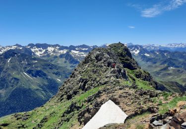
Randonnée Marche de 5 km à découvrir à Occitanie, Hautes-Pyrénées, Bagnères-de-Bigorre. Cette randonnée est proposée par mondalu.
Description
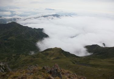
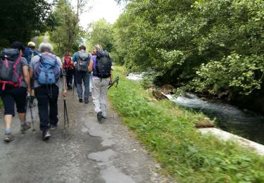
Cet itinéraire sans difficulté vous mène jusqu'au site de la croix de Béliou, empreint du mystère des légendes de la mythologie pyrénéenne. Vous pourrez également apprécier un magnifique point de vue sur le pic du Midi de Bigorre et le pic du Montaigu.
Localisation
Pays :
France
Région :
Occitanie
Département/Province :
Hautes-Pyrénées
Commune :
Bagnères-de-Bigorre
Localité :
Unknown
Départ:(Dec)
Départ:(UTM)
264148 ; 4767719 (31T) N.
Commentaires
Randonnées à proximité
![Randonnée Marche Bagnères-de-Bigorre - Le pic de Montaigu - Photo](https://media.geolcdn.com/t/375/260/ext.jpg?maxdim=2&url=https%3A%2F%2Fservices.sitytrail.com%2FGeolivesWS%2FDownloadMedia.ashx%3FTrailID%3D105593%26Media%3D9362_6.jpg)
![Marche Marche](https://static1.geolcdn.com/sitytour/trail-icons/101.png)
Le pic de Montaigu
Marche
Difficile
(1)
Bagnères-de-Bigorre,
Occitanie,
Hautes-Pyrénées,
France
![](/images/other/stat-length.png)
9 km | 25 km-effort
6h 0min
![](https://static1.geolcdn.com/siteimages/upload/files/16400158638029165_repeat_loop_refresh_sync_direction_icon.png)
Oui
![Randonnée Marche Beaudéan - LESPONNE entre torrents et cascades (G3) fait le 17 Juillet 2020](https://media.geolcdn.com/t/375/260/e61486eb-19e7-488b-bc78-39d6109d1c0c.jpg&format=jpg&maxdim=2)
![Marche Marche](https://static1.geolcdn.com/sitytour/trail-icons/101.png)
LESPONNE entre torrents et cascades (G3) fait le 17 Juillet 2020"2479379"
Marche
Très facile
Beaudéan,
Occitanie,
Hautes-Pyrénées,
France
![](/images/other/stat-length.png)
8,8 km | 12,9 km-effort
4h 30min
![](https://static1.geolcdn.com/siteimages/upload/files/16400158638029165_repeat_loop_refresh_sync_direction_icon.png)
Oui
![Randonnée Marche Germs-sur-l'Oussouet - FEU 2015 - Etape 6 - Photo](https://media.geolcdn.com/t/375/260/ext.jpg?maxdim=2&url=https%3A%2F%2Fstatic1.geolcdn.com%2Fsiteimages%2Fupload%2Ffiles%2F1553511878bg_sport_marche.png)
![Marche Marche](https://static1.geolcdn.com/sitytour/trail-icons/101.png)
FEU 2015 - Etape 6
Marche
Facile
(3)
Germs-sur-l'Oussouet,
Occitanie,
Hautes-Pyrénées,
France
![](/images/other/stat-length.png)
17,3 km | 25 km-effort
5h 6min
![](https://static1.geolcdn.com/siteimages/upload/files/16400158638029165_repeat_loop_refresh_sync_direction_icon.png)
Non
![Randonnée Marche Bagnères-de-Bigorre - FEU 2015 - Etape 5 - Photo](https://media.geolcdn.com/t/375/260/ext.jpg?maxdim=2&url=https%3A%2F%2Fstatic1.geolcdn.com%2Fsiteimages%2Fupload%2Ffiles%2F1553511878bg_sport_marche.png)
![Marche Marche](https://static1.geolcdn.com/sitytour/trail-icons/101.png)
FEU 2015 - Etape 5
Marche
Facile
(1)
Bagnères-de-Bigorre,
Occitanie,
Hautes-Pyrénées,
France
![](/images/other/stat-length.png)
18,2 km | 30 km-effort
6h 29min
![](https://static1.geolcdn.com/siteimages/upload/files/16400158638029165_repeat_loop_refresh_sync_direction_icon.png)
Non
![Randonnée Marche Bagnères-de-Bigorre - Gerde - Photo](https://media.geolcdn.com/t/375/260/5dcd799a-ca45-4fad-9e66-85989c427a1f.jpg&format=jpg&maxdim=2)
![Marche Marche](https://static1.geolcdn.com/sitytour/trail-icons/101.png)
Gerde
Marche
Facile
Bagnères-de-Bigorre,
Occitanie,
Hautes-Pyrénées,
France
![](/images/other/stat-length.png)
9,7 km | 12,2 km-effort
2h 49min
![](https://static1.geolcdn.com/siteimages/upload/files/16400158638029165_repeat_loop_refresh_sync_direction_icon.png)
Oui
![Randonnée V.T.T. Bagnères-de-Bigorre - Randonnée 1 mai haut de Bagneres - Photo](https://media.geolcdn.com/t/375/260/4a87d4a3-5d4a-42ce-b248-b29ff1010a7f.jpg&format=jpg&maxdim=2)
![V.T.T. V.T.T.](https://static1.geolcdn.com/sitytour/trail-icons/202.png)
Randonnée 1 mai haut de Bagneres
V.T.T.
Très difficile
Bagnères-de-Bigorre,
Occitanie,
Hautes-Pyrénées,
France
![](/images/other/stat-length.png)
28 km | 38 km-effort
3h 18min
![](https://static1.geolcdn.com/siteimages/upload/files/16400158638029165_repeat_loop_refresh_sync_direction_icon.png)
Oui
![Randonnée Marche Bagnères-de-Bigorre - Le montaigu - Photo](https://media.geolcdn.com/t/375/260/0d2a2a6a-e1bd-4469-8cd9-e542097178ef.jpg&format=jpg&maxdim=2)
![Marche Marche](https://static1.geolcdn.com/sitytour/trail-icons/101.png)
Le montaigu
Marche
Difficile
Bagnères-de-Bigorre,
Occitanie,
Hautes-Pyrénées,
France
![](/images/other/stat-length.png)
9,3 km | 25 km-effort
7h 41min
![](https://static1.geolcdn.com/siteimages/upload/files/16400158638029165_repeat_loop_refresh_sync_direction_icon.png)
Oui
![Randonnée Marche Bagnères-de-Bigorre - Bedat par croix de Manse - Photo](https://media.geolcdn.com/t/375/260/ext.jpg?maxdim=2&url=https%3A%2F%2Fservices.sitytrail.com%2FGeolivesWS%2FDownloadMedia.ashx%3FTrailID%3D1028179%26Media%3Dfix__20180824133821.jpg)
![Marche Marche](https://static1.geolcdn.com/sitytour/trail-icons/101.png)
Bedat par croix de Manse
Marche
Très facile
Bagnères-de-Bigorre,
Occitanie,
Hautes-Pyrénées,
France
![](/images/other/stat-length.png)
6 km | 8,8 km-effort
3h 48min
![](https://static1.geolcdn.com/siteimages/upload/files/16400158638029165_repeat_loop_refresh_sync_direction_icon.png)
Oui
![Randonnée Marche Bagnères-de-Bigorre - Bedat par croix de Manse - Photo](https://media.geolcdn.com/t/375/260/ext.jpg?maxdim=2&url=https%3A%2F%2Fservices.sitytrail.com%2FGeolivesWS%2FDownloadMedia.ashx%3FTrailID%3D1028018%26Media%3Dfix__20180824133821.jpg)
![Marche Marche](https://static1.geolcdn.com/sitytour/trail-icons/101.png)
Bedat par croix de Manse
Marche
Très facile
Bagnères-de-Bigorre,
Occitanie,
Hautes-Pyrénées,
France
![](/images/other/stat-length.png)
6 km | 8,8 km-effort
3h 48min
![](https://static1.geolcdn.com/siteimages/upload/files/16400158638029165_repeat_loop_refresh_sync_direction_icon.png)
Oui