![](/images/other/stat-length.png)
![Randonnée Marche Nigüelas - Nigüelas - Photo](https://media.geolcdn.com/t/1900/400/6ab0ca70-cf11-44f7-b7c2-205978561fb0.jpg&format=pjpeg&maxdim=2)
Nigüelas
jpipacific
Utilisateur
![Longueur](/images/other/stat-length.png)
![Altitude max](https://static1.geolcdn.com/siteimages/upload/files/1508320355ic_sort_altitude_max_24dp.png)
![Dénivelé positif](https://static1.geolcdn.com/siteimages/upload/files/1508320355ic_sort_den_pos_24dp.png)
![Km-Effort](/images/other/stat-length.png)
![Altitude min](https://static1.geolcdn.com/siteimages/upload/files/1508320355ic_sort_altitude_min_24dp.png)
![Dénivelé négatif](https://static1.geolcdn.com/siteimages/upload/files/1508320355ic_sort_den_neg_24dp.png)
![Boucle](https://static1.geolcdn.com/siteimages/upload/files/16400158638029165_repeat_loop_refresh_sync_direction_icon.png)
![Marche](https://static1.geolcdn.com/sitytour/trail-icons/101.png)
3h18
Difficulté : Moyen
![Scannez ce code QR pour ouvrir la randonnée dans l'application SityTrail](https://capi.geolives.com/qq0zvz2zws4bq2lad0pu/sitytour/trails/3539429/qr.png?size=200)
Application GPS de randonnée GRATUITE
À propos
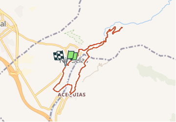
Randonnée Marche de 9,5 km à découvrir à Andalousie, Grenade, Nigüelas. Cette randonnée est proposée par jpipacific.
Description
Balade un peu sportive.
La première partie est très facile et très sympa.
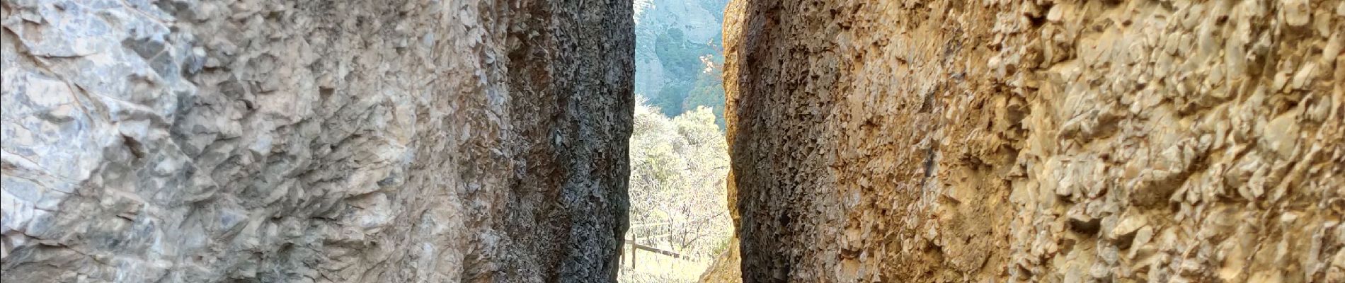
Le chemin circule sur des aménagements de grilles, de couloirs de roches, de bords de falaises bien sécurisés par des barrières. Le chemin monte doucement.
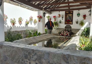
Ensuite, nous avons suivi le chemin qui monte jusqu'à une plate-forme herbeuse où nous avons piqueniqué.
Puis, demi tour et nous sommes descendu jusqu'au village de Acequias par un chemin très facile et retour au point de départ.
Localisation
Commentaires
Randonnées à proximité
![Randonnée Marche El Valle - Melegis Vallée de l'Ecrin Murchas - Photo](https://media.geolcdn.com/t/375/260/f1fa611e-0db9-46f2-88b5-098f127a426b.jpg&format=jpg&maxdim=2)
![Marche Marche](https://static1.geolcdn.com/sitytour/trail-icons/101.png)
Marche
![](/images/other/stat-length.png)
![](https://static1.geolcdn.com/siteimages/upload/files/16400158638029165_repeat_loop_refresh_sync_direction_icon.png)
![Randonnée Marche nordique Villamena - conchar - Photo](https://media.geolcdn.com/t/375/260/3e42db77-b007-4f81-aea5-a8a60f9e1ec7.jpg&format=jpg&maxdim=2)
![Marche nordique Marche nordique](https://static1.geolcdn.com/sitytour/trail-icons/102.png)
Marche nordique
![](/images/other/stat-length.png)
![](https://static1.geolcdn.com/siteimages/upload/files/16400158638029165_repeat_loop_refresh_sync_direction_icon.png)
![Randonnée Marche El Valle - Autour de Meligis El valle - Photo](https://media.geolcdn.com/t/375/260/39cfb821-2d1b-4188-995c-c1ed919f0963.jpg&format=jpg&maxdim=2)
![Marche Marche](https://static1.geolcdn.com/sitytour/trail-icons/101.png)
Marche
![](/images/other/stat-length.png)
![](https://static1.geolcdn.com/siteimages/upload/files/16400158638029165_repeat_loop_refresh_sync_direction_icon.png)