![](/images/other/stat-length.png)
![Randonnée Marche Pradons - Pradons Gens Abeille 19km - Photo](https://media.geolcdn.com/t/1900/400/c0a42803-b9d9-46b0-bff8-8a8a9dfe0f63.jpg&format=pjpeg&maxdim=2)
Pradons Gens Abeille 19km
thonyc
Utilisateur GUIDE
![Longueur](/images/other/stat-length.png)
![Altitude max](https://static1.geolcdn.com/siteimages/upload/files/1508320355ic_sort_altitude_max_24dp.png)
![Dénivelé positif](https://static1.geolcdn.com/siteimages/upload/files/1508320355ic_sort_den_pos_24dp.png)
![Km-Effort](/images/other/stat-length.png)
![Altitude min](https://static1.geolcdn.com/siteimages/upload/files/1508320355ic_sort_altitude_min_24dp.png)
![Dénivelé négatif](https://static1.geolcdn.com/siteimages/upload/files/1508320355ic_sort_den_neg_24dp.png)
![Boucle](https://static1.geolcdn.com/siteimages/upload/files/16400158638029165_repeat_loop_refresh_sync_direction_icon.png)
![Marche](https://static1.geolcdn.com/sitytour/trail-icons/101.png)
5h50
Difficulté : Difficile
![Scannez ce code QR pour ouvrir la randonnée dans l'application SityTrail](https://capi.geolives.com/qq0zvz2zws4bq2lad0pu/sitytour/trails/3527486/qr.png?size=200)
Application GPS de randonnée GRATUITE
À propos
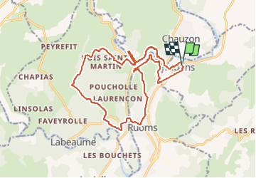
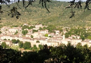
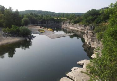
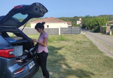
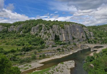
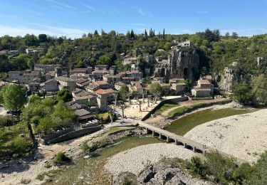
Randonnée Marche de 18,9 km à découvrir à Auvergne-Rhône-Alpes, Ardèche, Pradons. Cette randonnée est proposée par thonyc.
Description
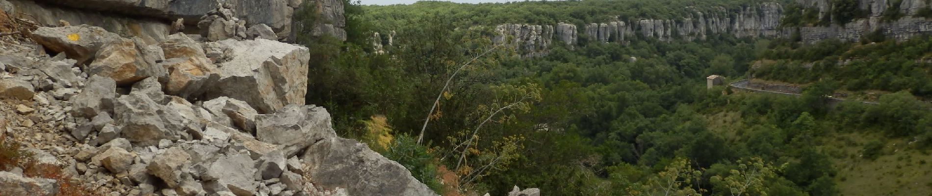
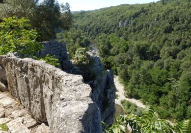
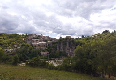
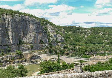
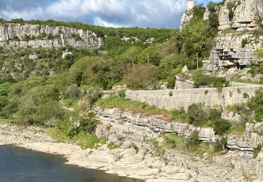
Le parcours est très varié avec de très beaux panoramas: Pradons, Ruoms, le cirque de Gens rives droite et gauche, le hameau de L'Abeille, dolmens.
ATTENTION: la rive gauche du cirque de Gens est plutôt sportive et réservée à des personnes ne souffrant pas de vertige et en bonne forme physique. Traversée du gué sur La Ligne.
Localisation
Commentaires
Randonnées à proximité
![Randonnée Marche nordique Lagorce - Lagorce - Photo](https://media.geolcdn.com/t/375/260/ext.jpg?maxdim=2&url=https%3A%2F%2Fservices.sitytrail.com%2FGeolivesWS%2FDownloadMedia.ashx%3FTrailID%3D205821%26Media%3Dfix__20130716082907.jpg)
![Marche nordique Marche nordique](https://static1.geolcdn.com/sitytour/trail-icons/102.png)
Marche nordique
![](/images/other/stat-length.png)
![](https://static1.geolcdn.com/siteimages/upload/files/16400158638029165_repeat_loop_refresh_sync_direction_icon.png)
![Randonnée Marche Ruoms - Cirque de Gens - Photo](https://media.geolcdn.com/t/375/260/ext.jpg?maxdim=2&url=https%3A%2F%2Fservices.sitytrail.com%2FGeolivesWS%2FDownloadMedia.ashx%3FTrailID%3D204709%26Media%3Dfix__20130714085419.jpg)
![Marche Marche](https://static1.geolcdn.com/sitytour/trail-icons/101.png)
Marche
![](/images/other/stat-length.png)
![](https://static1.geolcdn.com/siteimages/upload/files/16400158638029165_repeat_loop_refresh_sync_direction_icon.png)
![Randonnée Marche Ruoms - ARDECHES RUOMS Le cirque de gens - Photo](https://media.geolcdn.com/t/375/260/64a1ada7-e196-4279-8acd-3535097ebe03.jpg&format=jpg&maxdim=2)
![Marche Marche](https://static1.geolcdn.com/sitytour/trail-icons/101.png)
Marche
![](/images/other/stat-length.png)
![](https://static1.geolcdn.com/siteimages/upload/files/16400158638029165_repeat_loop_refresh_sync_direction_icon.png)
![Randonnée Marche Labeaume - Ruoms labeaume Chiapas Figère 15km - Photo](https://media.geolcdn.com/t/375/260/dc1e6df3-300e-487e-a90e-ef693e72da3d.jpg&format=jpg&maxdim=2)
![Marche Marche](https://static1.geolcdn.com/sitytour/trail-icons/101.png)
Marche
![](/images/other/stat-length.png)
![](https://static1.geolcdn.com/siteimages/upload/files/16400158638029165_repeat_loop_refresh_sync_direction_icon.png)
![Randonnée Marche Chauzon - camping le coin charmant Chauzon à Balazuc - Photo](https://media.geolcdn.com/t/375/260/9e3472da-95e6-4ca9-9834-4874ef8e1852.jpg&format=jpg&maxdim=2)
![Marche Marche](https://static1.geolcdn.com/sitytour/trail-icons/101.png)
Marche
![](/images/other/stat-length.png)
![](https://static1.geolcdn.com/siteimages/upload/files/16400158638029165_repeat_loop_refresh_sync_direction_icon.png)
![Randonnée Marche Balazuc - Balazuc Cirque de Gens 19km. - Photo](https://media.geolcdn.com/t/375/260/6d01c6fd-5949-41a2-b340-daa374c534bc.jpg&format=jpg&maxdim=2)
![Marche Marche](https://static1.geolcdn.com/sitytour/trail-icons/101.png)
Marche
![](/images/other/stat-length.png)
![](https://static1.geolcdn.com/siteimages/upload/files/16400158638029165_repeat_loop_refresh_sync_direction_icon.png)
![Randonnée Marche Balazuc - Balazuc Servieres Viel-Audon 9km. - Photo](https://media.geolcdn.com/t/375/260/c62c36d0-f3c1-47de-a635-486a1871b8d7.jpg&format=jpg&maxdim=2)
![Marche Marche](https://static1.geolcdn.com/sitytour/trail-icons/101.png)
Marche
![](/images/other/stat-length.png)
![](https://static1.geolcdn.com/siteimages/upload/files/16400158638029165_repeat_loop_refresh_sync_direction_icon.png)
![Randonnée sport Balazuc - Balazuc la tour de Jeanne le Viel Audon - Photo](https://media.geolcdn.com/t/375/260/d8c1c8fe-95e6-4adc-b1ae-0d66c200e42e.jpg&format=jpg&maxdim=2)
sport
![](/images/other/stat-length.png)
![](https://static1.geolcdn.com/siteimages/upload/files/16400158638029165_repeat_loop_refresh_sync_direction_icon.png)
![Randonnée sport Ruoms - Ruoms, Labeaume - Photo](https://media.geolcdn.com/t/375/260/7d33ddd7-f066-48c9-a760-0327f9148fdd.jpg&format=jpg&maxdim=2)
sport
![](/images/other/stat-length.png)
![](https://static1.geolcdn.com/siteimages/upload/files/16400158638029165_repeat_loop_refresh_sync_direction_icon.png)