![](/images/other/stat-length.png)
![Randonnée A pied Tanneron - Tanneron-les mimosas-13-01-23 - Photo](https://media.geolcdn.com/t/1900/400/85403fcc-7046-4556-a05b-24115c8c343f.jpg&format=pjpeg&maxdim=2)
Tanneron-les mimosas-13-01-23
Christiancordin
Utilisateur
![Longueur](/images/other/stat-length.png)
Longueur
16,1 km
![Altitude max](https://static1.geolcdn.com/siteimages/upload/files/1508320355ic_sort_altitude_max_24dp.png)
Altitude max
480 m
![Dénivelé positif](https://static1.geolcdn.com/siteimages/upload/files/1508320355ic_sort_den_pos_24dp.png)
Dénivelé positif
532 m
![Km-Effort](/images/other/stat-length.png)
Km-Effort
23 km
![Altitude min](https://static1.geolcdn.com/siteimages/upload/files/1508320355ic_sort_altitude_min_24dp.png)
Altitude min
155 m
![Dénivelé négatif](https://static1.geolcdn.com/siteimages/upload/files/1508320355ic_sort_den_neg_24dp.png)
Dénivelé négatif
532 m
![Boucle](https://static1.geolcdn.com/siteimages/upload/files/16400158638029165_repeat_loop_refresh_sync_direction_icon.png)
Boucle
Oui
Date de création :
2023-01-15 17:38:15.027
Dernière modification :
2023-01-15 17:47:17.594
![A pied](https://static1.geolcdn.com/sitytour/trail-icons/100.png)
5h16
Difficulté : Moyen
![Scannez ce code QR pour ouvrir la randonnée dans l'application SityTrail](https://capi.geolives.com/qq0zvz2zws4bq2lad0pu/sitytour/trails/3520060/qr.png?size=200)
Application GPS de randonnée GRATUITE
À propos
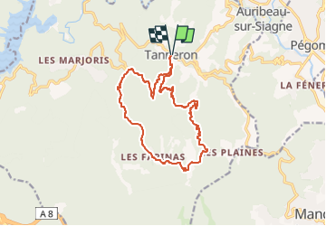
Randonnée A pied de 16,1 km à découvrir à Provence-Alpes-Côte d'Azur, Var, Tanneron. Cette randonnée est proposée par Christiancordin.
Description
Tanneron Pk après la mairie à droite conseillé aux randonneurs-colle d'Embarque-vallon des Serres-vallon de l'Aubarie-les Farinas-les Grailles-Les Margoutons-vallon de Latone-Tanneron.
Localisation
Pays :
France
Région :
Provence-Alpes-Côte d'Azur
Département/Province :
Var
Commune :
Tanneron
Localité :
Unknown
Départ:(Dec)
Départ:(UTM)
328553 ; 4828538 (32T) N.
Commentaires
Randonnées à proximité
![Randonnée A pied Tanneron - La chapelle de St Cassien des bois, le pont détruit et au fil de l'eau - Photo](https://media.geolcdn.com/t/375/260/a22ee1a2-3869-418b-b8c3-03abedec3efc.jpg&format=jpg&maxdim=2)
![A pied A pied](https://static1.geolcdn.com/sitytour/trail-icons/100.png)
La chapelle de St Cassien des bois, le pont détruit et au fil de l'eau
A pied
Facile
(5)
Tanneron,
Provence-Alpes-Côte d'Azur,
Var,
France
![](/images/other/stat-length.png)
7,3 km | 10,3 km-effort
2h 19min
![](https://static1.geolcdn.com/siteimages/upload/files/16400158638029165_repeat_loop_refresh_sync_direction_icon.png)
Oui
![Randonnée Marche Tanneron - Tanneron les mimosas - Photo](https://media.geolcdn.com/t/375/260/12594504-e357-426b-8d56-deee61931ae8.jpg&format=jpg&maxdim=2)
![Marche Marche](https://static1.geolcdn.com/sitytour/trail-icons/101.png)
Tanneron les mimosas
Marche
Très facile
(1)
Tanneron,
Provence-Alpes-Côte d'Azur,
Var,
France
![](/images/other/stat-length.png)
12 km | 17,8 km-effort
3h 25min
![](https://static1.geolcdn.com/siteimages/upload/files/16400158638029165_repeat_loop_refresh_sync_direction_icon.png)
Oui
![Randonnée A pied Le Tignet - Val de Siagne - Photo](https://media.geolcdn.com/t/375/260/876dd6c7-0972-4635-aa2a-412c508ab044.jpeg&format=jpg&maxdim=2)
![A pied A pied](https://static1.geolcdn.com/sitytour/trail-icons/100.png)
Val de Siagne
A pied
Facile
Le Tignet,
Provence-Alpes-Côte d'Azur,
Alpes-Maritimes,
France
![](/images/other/stat-length.png)
6,5 km | 9,5 km-effort
2h 9min
![](https://static1.geolcdn.com/siteimages/upload/files/16400158638029165_repeat_loop_refresh_sync_direction_icon.png)
Oui
![Randonnée Marche Tanneron - Tanneron - petite boucle 12-02-2022 - Photo](https://media.geolcdn.com/t/375/260/4604518f-6a34-43cf-8b51-a998f24d7a22.jpg&format=jpg&maxdim=2)
![Marche Marche](https://static1.geolcdn.com/sitytour/trail-icons/101.png)
Tanneron - petite boucle 12-02-2022
Marche
Facile
Tanneron,
Provence-Alpes-Côte d'Azur,
Var,
France
![](/images/other/stat-length.png)
7,5 km | 10,8 km-effort
2h 0min
![](https://static1.geolcdn.com/siteimages/upload/files/16400158638029165_repeat_loop_refresh_sync_direction_icon.png)
Oui
![Randonnée Marche Mandelieu-la-Napoule - Grand Duc Alternatif - Photo](https://media.geolcdn.com/t/375/260/ext.jpg?maxdim=2&url=https%3A%2F%2Fstatic1.geolcdn.com%2Fsiteimages%2Fupload%2Ffiles%2F1553511878bg_sport_marche.png)
![Marche Marche](https://static1.geolcdn.com/sitytour/trail-icons/101.png)
Grand Duc Alternatif
Marche
Très facile
(1)
Mandelieu-la-Napoule,
Provence-Alpes-Côte d'Azur,
Alpes-Maritimes,
France
![](/images/other/stat-length.png)
6,4 km | 9,1 km-effort
2h 0min
![](https://static1.geolcdn.com/siteimages/upload/files/16400158638029165_repeat_loop_refresh_sync_direction_icon.png)
Oui
![Randonnée Marche Mandelieu-la-Napoule - Grand Duc - Photo](https://media.geolcdn.com/t/375/260/bb4952b6-32f3-40dd-b274-07cfc3d80de4.jpg&format=jpg&maxdim=2)
![Marche Marche](https://static1.geolcdn.com/sitytour/trail-icons/101.png)
Grand Duc
Marche
Moyen
Mandelieu-la-Napoule,
Provence-Alpes-Côte d'Azur,
Alpes-Maritimes,
France
![](/images/other/stat-length.png)
8,9 km | 12,5 km-effort
2h 47min
![](https://static1.geolcdn.com/siteimages/upload/files/16400158638029165_repeat_loop_refresh_sync_direction_icon.png)
Oui
![Randonnée Marche Tanneron - Crêtes du Tanneron - Photo](https://media.geolcdn.com/t/375/260/d09f9b2b-44ce-4ff4-a28b-df768b7c8122.jpg&format=jpg&maxdim=2)
![Marche Marche](https://static1.geolcdn.com/sitytour/trail-icons/101.png)
Crêtes du Tanneron
Marche
Difficile
Tanneron,
Provence-Alpes-Côte d'Azur,
Var,
France
![](/images/other/stat-length.png)
14,9 km | 21 km-effort
5h 5min
![](https://static1.geolcdn.com/siteimages/upload/files/16400158638029165_repeat_loop_refresh_sync_direction_icon.png)
Oui
![Randonnée sport Tanneron - Tanneron - Photo](https://media.geolcdn.com/t/375/260/974aadb2-79c8-4954-8761-9180120909fd.jpg&format=jpg&maxdim=2)
Tanneron
sport
Très facile
Tanneron,
Provence-Alpes-Côte d'Azur,
Var,
France
![](/images/other/stat-length.png)
9,7 km | 13,9 km-effort
Inconnu
![](https://static1.geolcdn.com/siteimages/upload/files/16400158638029165_repeat_loop_refresh_sync_direction_icon.png)
Oui
![Randonnée Marche Tanneron - 2024-02-16 Tanneron Mimosas - Photo](https://media.geolcdn.com/t/375/260/ec7db3bf-cda8-4c96-a43b-2447256cb9f8.jpg&format=jpg&maxdim=2)
![Marche Marche](https://static1.geolcdn.com/sitytour/trail-icons/101.png)
2024-02-16 Tanneron Mimosas
Marche
Moyen
Tanneron,
Provence-Alpes-Côte d'Azur,
Var,
France
![](/images/other/stat-length.png)
11,1 km | 17,8 km-effort
4h 2min
![](https://static1.geolcdn.com/siteimages/upload/files/16400158638029165_repeat_loop_refresh_sync_direction_icon.png)
Oui