![](/images/other/stat-length.png)
![Randonnée Marche Namur - NAMUR _ Marche Fédérale _ NA _ 15/01/2023 - Photo](https://media.geolcdn.com/t/1900/400/6985bd01-5aff-4f4a-aa41-cca5e21b2bb0.jpg&format=pjpeg&maxdim=2)
NAMUR _ Marche Fédérale _ NA _ 15/01/2023
jeangulu
Utilisateur
![Longueur](/images/other/stat-length.png)
Longueur
24 km
![Altitude max](https://static1.geolcdn.com/siteimages/upload/files/1508320355ic_sort_altitude_max_24dp.png)
Altitude max
228 m
![Dénivelé positif](https://static1.geolcdn.com/siteimages/upload/files/1508320355ic_sort_den_pos_24dp.png)
Dénivelé positif
426 m
![Km-Effort](/images/other/stat-length.png)
Km-Effort
30 km
![Altitude min](https://static1.geolcdn.com/siteimages/upload/files/1508320355ic_sort_altitude_min_24dp.png)
Altitude min
71 m
![Dénivelé négatif](https://static1.geolcdn.com/siteimages/upload/files/1508320355ic_sort_den_neg_24dp.png)
Dénivelé négatif
426 m
![Boucle](https://static1.geolcdn.com/siteimages/upload/files/16400158638029165_repeat_loop_refresh_sync_direction_icon.png)
Boucle
Oui
Date de création :
2023-01-15 09:01:19.821
Dernière modification :
2023-01-16 10:49:43.157
![Marche](https://static1.geolcdn.com/sitytour/trail-icons/101.png)
5h59
Difficulté : Moyen
![Scannez ce code QR pour ouvrir la randonnée dans l'application SityTrail](https://capi.geolives.com/qq0zvz2zws4bq2lad0pu/sitytour/trails/3519768/qr.png?size=200)
Application GPS de randonnée GRATUITE
À propos
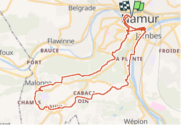
Randonnée Marche de 24 km à découvrir à Wallonie, Namur, Namur. Cette randonnée est proposée par jeangulu.
Description
Point de départ : Institut Sainte-Ursule - Rue de Bruxelles , 78 - NAMUR
Organisateur : NA 029 - LES SPITANTS DE NAMUR ASBL.
44 ' Marche de la Citadelle
Localisation
Pays :
Belgique
Région :
Wallonie
Département/Province :
Namur
Commune :
Namur
Localité :
Namur
Départ:(Dec)
Départ:(UTM)
632061 ; 5592219 (31U) N.
Commentaires
Randonnées à proximité
![Randonnée Marche Namur - Balade dans le bois de la Vecquée - Photo](https://media.geolcdn.com/t/375/260/ext.jpg?maxdim=2&url=https%3A%2F%2Fservices.sitytrail.com%2FGeolivesWS%2FDownloadMedia.ashx%3FTrailID%3D116970%26Media%3D93b7e593-adca-4c1d-a47c-e05bb1cf45a1.JPG)
![Marche Marche](https://static1.geolcdn.com/sitytour/trail-icons/101.png)
Balade dans le bois de la Vecquée
Marche
Moyen
(6)
Namur,
Wallonie,
Namur,
Belgique
![](/images/other/stat-length.png)
13,2 km | 18,4 km-effort
3h 20min
![](https://static1.geolcdn.com/siteimages/upload/files/16400158638029165_repeat_loop_refresh_sync_direction_icon.png)
Oui
![Randonnée Marche Namur - Nuit du scoutisme - Namur - Photo](https://media.geolcdn.com/t/375/260/59c09917-a863-4933-801b-fff702066ffd.jpg&format=jpg&maxdim=2)
![Marche Marche](https://static1.geolcdn.com/sitytour/trail-icons/101.png)
Nuit du scoutisme - Namur
Marche
Moyen
(7)
Namur,
Wallonie,
Namur,
Belgique
![](/images/other/stat-length.png)
5,5 km | 6,1 km-effort
1h 32min
![](https://static1.geolcdn.com/siteimages/upload/files/16400158638029165_repeat_loop_refresh_sync_direction_icon.png)
Oui
![Randonnée Marche Namur - RF-Na-04 - Namur - 2025-02-11 - Photo](https://media.geolcdn.com/t/375/260/ext.jpg?maxdim=2&url=https%3A%2F%2Fstatic1.geolcdn.com%2Fsiteimages%2Fupload%2Ffiles%2F1553511878bg_sport_marche.png)
![Marche Marche](https://static1.geolcdn.com/sitytour/trail-icons/101.png)
RF-Na-04 - Namur - 2025-02-11
Marche
Moyen
(6)
Namur,
Wallonie,
Namur,
Belgique
![](/images/other/stat-length.png)
6,8 km | 9,2 km-effort
2h 5min
![](https://static1.geolcdn.com/siteimages/upload/files/16400158638029165_repeat_loop_refresh_sync_direction_icon.png)
Oui
![Randonnée Marche Namur - La Plante 16 Km - Photo](https://media.geolcdn.com/t/375/260/d14bf9b4-85d7-458d-beb2-079d8e396b5c.jpeg&format=jpg&maxdim=2)
![Marche Marche](https://static1.geolcdn.com/sitytour/trail-icons/101.png)
La Plante 16 Km
Marche
Facile
(1)
Namur,
Wallonie,
Namur,
Belgique
![](/images/other/stat-length.png)
15,9 km | 21 km-effort
5h 34min
![](https://static1.geolcdn.com/siteimages/upload/files/16400158638029165_repeat_loop_refresh_sync_direction_icon.png)
Oui
![Randonnée Marche Namur - De Boninne aux Rochers de Marche-les-Dames - Photo](https://media.geolcdn.com/t/375/260/ext.jpg?maxdim=2&url=https%3A%2F%2Fservices.sitytrail.com%2FGeolivesWS%2FDownloadMedia.ashx%3FTrailID%3D1000620%26Media%3D20180707135425.jpg)
![Marche Marche](https://static1.geolcdn.com/sitytour/trail-icons/101.png)
De Boninne aux Rochers de Marche-les-Dames
Marche
Facile
(1)
Namur,
Wallonie,
Namur,
Belgique
![](/images/other/stat-length.png)
10,8 km | 14,6 km-effort
3h 5min
![](https://static1.geolcdn.com/siteimages/upload/files/16400158638029165_repeat_loop_refresh_sync_direction_icon.png)
Oui
![Randonnée Marche Namur - La balade des quais à Namur - Photo](https://media.geolcdn.com/t/375/260/ext.jpg?maxdim=2&url=https%3A%2F%2Fservices.sitytrail.com%2FGeolivesWS%2FDownloadMedia.ashx%3FTrailID%3D362945%26Media%3D1faf5953-f3d8-4ec7-ad30-b2dea219bb51.JPG)
![Marche Marche](https://static1.geolcdn.com/sitytour/trail-icons/101.png)
La balade des quais à Namur
Marche
Très facile
(3)
Namur,
Wallonie,
Namur,
Belgique
![](/images/other/stat-length.png)
7,6 km | 8,6 km-effort
1h 53min
![](https://static1.geolcdn.com/siteimages/upload/files/16400158638029165_repeat_loop_refresh_sync_direction_icon.png)
Oui
![Randonnée Vélo Namur - Route du vin un jour Route du vin toujours - Photo](https://media.geolcdn.com/t/375/260/ext.jpg?maxdim=2&url=https%3A%2F%2Fservices.sitytrail.com%2FGeolivesWS%2FDownloadMedia.ashx%3FTrailID%3D640338%26Media%3Dc3ae23a8-7b1c-4265-a2e6-0841c4658a8c.jpg)
![Vélo Vélo](https://static1.geolcdn.com/sitytour/trail-icons/200.png)
Route du vin un jour Route du vin toujours
Vélo
Facile
(1)
Namur,
Wallonie,
Namur,
Belgique
![](/images/other/stat-length.png)
33 km | 38 km-effort
2h 11min
![](https://static1.geolcdn.com/siteimages/upload/files/16400158638029165_repeat_loop_refresh_sync_direction_icon.png)
Oui
![Randonnée Marche Namur - ERPENT - Photo](https://media.geolcdn.com/t/375/260/ext.jpg?maxdim=2&url=https%3A%2F%2Fservices.sitytrail.com%2FGeolivesWS%2FDownloadMedia.ashx%3FTrailID%3D405889%26Media%3Dfix__20150409153931.jpg)
![Marche Marche](https://static1.geolcdn.com/sitytour/trail-icons/101.png)
![Randonnée Marche Namur - Namur Basse Meuse (Lives-sur-Meuse) - Photo](https://media.geolcdn.com/t/375/260/ext.jpg?maxdim=2&url=https%3A%2F%2Fstatic1.geolcdn.com%2Fsiteimages%2Fupload%2Ffiles%2F1553511878bg_sport_marche.png)
![Marche Marche](https://static1.geolcdn.com/sitytour/trail-icons/101.png)
Namur Basse Meuse (Lives-sur-Meuse)
Marche
Très facile
(2)
Namur,
Wallonie,
Namur,
Belgique
![](/images/other/stat-length.png)
5,8 km | 7,6 km-effort
1h 38min
![](https://static1.geolcdn.com/siteimages/upload/files/16400158638029165_repeat_loop_refresh_sync_direction_icon.png)
Oui