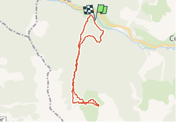
![](/images/other/stat-length.png)
![Randonnée Ski de randonnée Cervières - Crêtes de la lauze ou voyage dans les entrailles de terre rouge - Photo](https://media.geolcdn.com/t/1900/400/ext.pjpeg?maxdim=2&url=https%3A%2F%2Fmedia.geolcdn.com%2Ff%2Fda38ba36-922f-44c9-9446-6f239bb0c246.jpg)
Crêtes de la lauze ou voyage dans les entrailles de terre rouge
tchoua
Utilisateur
![Longueur](/images/other/stat-length.png)
![Altitude max](https://static1.geolcdn.com/siteimages/upload/files/1508320355ic_sort_altitude_max_24dp.png)
![Dénivelé positif](https://static1.geolcdn.com/siteimages/upload/files/1508320355ic_sort_den_pos_24dp.png)
![Km-Effort](/images/other/stat-length.png)
![Altitude min](https://static1.geolcdn.com/siteimages/upload/files/1508320355ic_sort_altitude_min_24dp.png)
![Dénivelé négatif](https://static1.geolcdn.com/siteimages/upload/files/1508320355ic_sort_den_neg_24dp.png)
![Boucle](https://static1.geolcdn.com/siteimages/upload/files/16400158638029165_repeat_loop_refresh_sync_direction_icon.png)
![Ski de randonnée](https://static1.geolcdn.com/sitytour/trail-icons/503.png)
2h27
Difficulté : Moyen
![Scannez ce code QR pour ouvrir la randonnée dans l'application SityTrail](https://capi.geolives.com/qq0zvz2zws4bq2lad0pu/sitytour/trails/3516431/qr.png?size=200)
Application GPS de randonnée GRATUITE
À propos
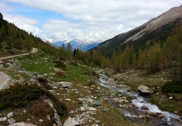
Randonnée Ski de randonnée de 8,3 km à découvrir à Provence-Alpes-Côte d'Azur, Hautes-Alpes, Cervières. Cette randonnée est proposée par tchoua.
Description
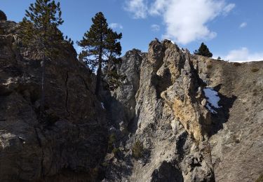
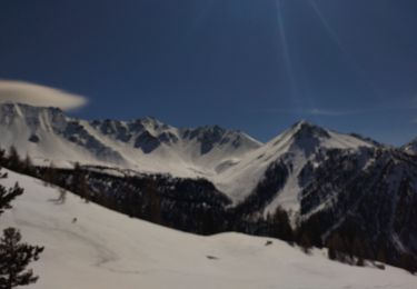
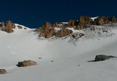
Belle randonnée à faire ,pas très longue , montée et descente se déroule dans le canyon avec un débouché vers la fin en forêt et des pentes plus douces , au sommet panorama magnifique à 360°.ceci dit il faut un bon niveau à ski pour la descente.
Localisation
Commentaires
Randonnées à proximité
![Randonnée Marche Briançon - Briançon - Parc de la Schappe Cité Vauban Ancien Fort des Trois Têtes - 6.5km 335m 2h05 - 2014 05 28 - Photo](https://media.geolcdn.com/t/375/260/ext.jpg?maxdim=2&url=https%3A%2F%2Fservices.sitytrail.com%2FGeolivesWS%2FDownloadMedia.ashx%3FTrailID%3D307005%26Media%3Dfix__20140528152619.jpg)
![Marche Marche](https://static1.geolcdn.com/sitytour/trail-icons/101.png)
Marche
![](/images/other/stat-length.png)
![](https://static1.geolcdn.com/siteimages/upload/files/16400158638029165_repeat_loop_refresh_sync_direction_icon.png)
![Randonnée Marche Val-des-Prés - le Chenaillet et le grand charvia - Photo](https://media.geolcdn.com/t/375/260/ext.jpg?maxdim=2&url=https%3A%2F%2Fservices.sitytrail.com%2FGeolivesWS%2FDownloadMedia.ashx%3FTrailID%3D1005383%26Media%3Dfix__20180716131306.jpg)
![Marche Marche](https://static1.geolcdn.com/sitytour/trail-icons/101.png)
Marche
![](/images/other/stat-length.png)
![](https://static1.geolcdn.com/siteimages/upload/files/16400158638029165_repeat_loop_refresh_sync_direction_icon.png)
![Randonnée Raquettes à neige Cervières - Le Laus - Vers Izoard par le sentier de la Mule - Photo](https://media.geolcdn.com/t/375/260/ext.jpg?maxdim=2&url=https%3A%2F%2Fservices.sitytrail.com%2FGeolivesWS%2FDownloadMedia.ashx%3FTrailID%3D249730%26Media%3Dfix__20140214134344.jpg)
![Raquettes à neige Raquettes à neige](https://static1.geolcdn.com/sitytour/trail-icons/504.png)
Raquettes à neige
![](/images/other/stat-length.png)
![](https://static1.geolcdn.com/siteimages/upload/files/16400158638029165_repeat_loop_refresh_sync_direction_icon.png)
![Randonnée Marche Briançon - Circuit: Fort des 3 Têtes et Fort Dauphin - Photo](https://media.geolcdn.com/t/375/260/ext.jpg?maxdim=2&url=https%3A%2F%2Fservices.sitytrail.com%2FGeolivesWS%2FDownloadMedia.ashx%3FTrailID%3D164654%26Media%3D20121129113142.jpeg)
![Marche Marche](https://static1.geolcdn.com/sitytour/trail-icons/101.png)
Marche
![](/images/other/stat-length.png)
![](https://static1.geolcdn.com/siteimages/upload/files/16400158638029165_repeat_loop_refresh_sync_direction_icon.png)
![Randonnée Marche Briançon - Briancon: Fort des Trois tètes - Photo](https://media.geolcdn.com/t/375/260/ext.jpg?maxdim=2&url=https%3A%2F%2Fservices.sitytrail.com%2FGeolivesWS%2FDownloadMedia.ashx%3FTrailID%3D163710%26Media%3D20121118161618.jpeg)
![Marche Marche](https://static1.geolcdn.com/sitytour/trail-icons/101.png)
Marche
![](/images/other/stat-length.png)
![](https://static1.geolcdn.com/siteimages/upload/files/16400158638029165_repeat_loop_refresh_sync_direction_icon.png)
![Randonnée Marche Briançon - Briancon: Le tour du Fort des 3 Têtes - Photo](https://media.geolcdn.com/t/375/260/ext.jpg?maxdim=2&url=https%3A%2F%2Fservices.sitytrail.com%2FGeolivesWS%2FDownloadMedia.ashx%3FTrailID%3D158752%26Media%3Dd80e0258-2803-4544-9658-ace38faa0fc2.jpg)
![Marche Marche](https://static1.geolcdn.com/sitytour/trail-icons/101.png)
Marche
![](/images/other/stat-length.png)
![](https://static1.geolcdn.com/siteimages/upload/files/16400158638029165_repeat_loop_refresh_sync_direction_icon.png)
![Randonnée Marche Cervières - Cerviere lac Gignoux - Photo](https://media.geolcdn.com/t/375/260/ext.jpg?maxdim=2&url=https%3A%2F%2Fmedia.geolcdn.com%2Ff%2Ffb49a4e5-e730-4029-93ed-5953862acf9b.jpg)
![Marche Marche](https://static1.geolcdn.com/sitytour/trail-icons/101.png)
Marche
![](/images/other/stat-length.png)
![](https://static1.geolcdn.com/siteimages/upload/files/16400158638029165_repeat_loop_refresh_sync_direction_icon.png)
![Randonnée Ski de randonnée Cervières - bas de Rochebrune - Photo](https://media.geolcdn.com/t/375/260/ext.jpg?maxdim=2&url=https%3A%2F%2Fmedia.geolcdn.com%2Ff%2Fd64c6526-e83a-47ea-838a-86952d62a8b3.jpg)
![Ski de randonnée Ski de randonnée](https://static1.geolcdn.com/sitytour/trail-icons/503.png)
Ski de randonnée
![](/images/other/stat-length.png)
![](https://static1.geolcdn.com/siteimages/upload/files/16400158638029165_repeat_loop_refresh_sync_direction_icon.png)
![Randonnée V.T.T. Briançon - Briançon -Fort Gondran -Montgenevre - Photo](https://media.geolcdn.com/t/375/260/ext.jpg?maxdim=2&url=https%3A%2F%2Fmedia.geolcdn.com%2Ff%2F9b891558-2b7c-493c-bc7a-da73440fdad0.jpg)
![V.T.T. V.T.T.](https://static1.geolcdn.com/sitytour/trail-icons/202.png)
V.T.T.
![](/images/other/stat-length.png)
![](https://static1.geolcdn.com/siteimages/upload/files/16400158638029165_repeat_loop_refresh_sync_direction_icon.png)