![](/images/other/stat-length.png)
![Randonnée Marche Gesves - MOZET (Paradis des lièvres) - Photo](https://media.geolcdn.com/t/1900/400/ext.pjpeg?maxdim=2&url=https%3A%2F%2Fstatic1.geolcdn.com%2Fsiteimages%2Fupload%2Ffiles%2F1553511878bg_sport_marche.png)
MOZET (Paradis des lièvres)
GerardBouche
Utilisateur
![Longueur](/images/other/stat-length.png)
Longueur
9,8 km
![Altitude max](https://static1.geolcdn.com/siteimages/upload/files/1508320355ic_sort_altitude_max_24dp.png)
Altitude max
215 m
![Dénivelé positif](https://static1.geolcdn.com/siteimages/upload/files/1508320355ic_sort_den_pos_24dp.png)
Dénivelé positif
194 m
![Km-Effort](/images/other/stat-length.png)
Km-Effort
12,4 km
![Altitude min](https://static1.geolcdn.com/siteimages/upload/files/1508320355ic_sort_altitude_min_24dp.png)
Altitude min
131 m
![Dénivelé négatif](https://static1.geolcdn.com/siteimages/upload/files/1508320355ic_sort_den_neg_24dp.png)
Dénivelé négatif
194 m
![Boucle](https://static1.geolcdn.com/siteimages/upload/files/16400158638029165_repeat_loop_refresh_sync_direction_icon.png)
Boucle
Oui
Date de création :
2016-03-09 00:00:00.0
Dernière modification :
2016-03-09 00:00:00.0
![Marche](https://static1.geolcdn.com/sitytour/trail-icons/101.png)
2h40
Difficulté : Facile
![Scannez ce code QR pour ouvrir la randonnée dans l'application SityTrail](https://capi.geolives.com/qq0zvz2zws4bq2lad0pu/sitytour/trails/351419/qr.png?size=200)
Application GPS de randonnée GRATUITE
À propos
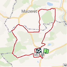
Randonnée Marche de 9,8 km à découvrir à Wallonie, Namur, Gesves. Cette randonnée est proposée par GerardBouche.
Description
Au départ de l'église par le "Paradis des lièvres", la "Haie Marie"et le village de Maizeret.Retour par le "Bois Wiame et passage à proximité des anciennes carrières.
Localisation
Pays :
Belgique
Région :
Wallonie
Département/Province :
Namur
Commune :
Gesves
Localité :
Mozet
Départ:(Dec)
Départ:(UTM)
641084 ; 5589518 (31U) N.
Commentaires
Randonnées à proximité
![Randonnée Marche Gesves - RB-Na-01_Faulx-les-Tombes_via-racc - Photo](https://media.geolcdn.com/t/375/260/ext.jpg?maxdim=2&url=https%3A%2F%2Fservices.sitytrail.com%2FGeolivesWS%2FDownloadMedia.ashx%3FTrailID%3D213609%26Media%3D506f23b2-0581-4f03-b006-9ca575596278.jpg)
![Marche Marche](https://static1.geolcdn.com/sitytour/trail-icons/101.png)
RB-Na-01_Faulx-les-Tombes_via-racc
Marche
Très difficile
(15)
Gesves,
Wallonie,
Namur,
Belgique
![](/images/other/stat-length.png)
18,3 km | 25 km-effort
5h 34min
![](https://static1.geolcdn.com/siteimages/upload/files/16400158638029165_repeat_loop_refresh_sync_direction_icon.png)
Oui
![Randonnée Marche Gesves - RB-Na-01_Faulx-les-Tombes - Photo](https://media.geolcdn.com/t/375/260/ext.jpg?maxdim=2&url=https%3A%2F%2Fservices.sitytrail.com%2FGeolivesWS%2FDownloadMedia.ashx%3FTrailID%3D179626%26Media%3D506f23b2-0581-4f03-b006-9ca575596278.jpg)
![Marche Marche](https://static1.geolcdn.com/sitytour/trail-icons/101.png)
RB-Na-01_Faulx-les-Tombes
Marche
Très difficile
(15)
Gesves,
Wallonie,
Namur,
Belgique
![](/images/other/stat-length.png)
25 km | 33 km-effort
7h 26min
![](https://static1.geolcdn.com/siteimages/upload/files/16400158638029165_repeat_loop_refresh_sync_direction_icon.png)
Oui
![Randonnée Marche Andenne - GESVES- Goyet- n°08- Eau - Photo](https://media.geolcdn.com/t/375/260/ext.jpg?maxdim=2&url=https%3A%2F%2Fservices.sitytrail.com%2FGeolivesWS%2FDownloadMedia.ashx%3FTrailID%3D121402%26Media%3D624555aa-5d04-4964-8666-f3856017c3be.jpg)
![Marche Marche](https://static1.geolcdn.com/sitytour/trail-icons/101.png)
GESVES- Goyet- n°08- Eau
Marche
Difficile
(9)
Andenne,
Wallonie,
Namur,
Belgique
![](/images/other/stat-length.png)
9,1 km | 12,3 km-effort
2h 36min
![](https://static1.geolcdn.com/siteimages/upload/files/16400158638029165_repeat_loop_refresh_sync_direction_icon.png)
Oui
![Randonnée Marche Gesves - GESVES- Le Pré D'Amite- N°07- Bois - Photo](https://media.geolcdn.com/t/375/260/ext.jpg?maxdim=2&url=https%3A%2F%2Fservices.sitytrail.com%2FGeolivesWS%2FDownloadMedia.ashx%3FTrailID%3D121401%26Media%3D56c27e3a-fec1-4804-be43-ac45373f04b7.jpg)
![Marche Marche](https://static1.geolcdn.com/sitytour/trail-icons/101.png)
GESVES- Le Pré D'Amite- N°07- Bois
Marche
Difficile
(13)
Gesves,
Wallonie,
Namur,
Belgique
![](/images/other/stat-length.png)
9,4 km | 12,5 km-effort
2h 41min
![](https://static1.geolcdn.com/siteimages/upload/files/16400158638029165_repeat_loop_refresh_sync_direction_icon.png)
Oui
![Randonnée Marche Gesves - GESVES -Mozet- N°06- Biodiversité - Photo](https://media.geolcdn.com/t/375/260/ext.jpg?maxdim=2&url=https%3A%2F%2Fservices.sitytrail.com%2FGeolivesWS%2FDownloadMedia.ashx%3FTrailID%3D121400%26Media%3D865b88e1-90ed-4454-a365-7e82ed8502df.JPG)
![Marche Marche](https://static1.geolcdn.com/sitytour/trail-icons/101.png)
GESVES -Mozet- N°06- Biodiversité
Marche
Facile
(10)
Gesves,
Wallonie,
Namur,
Belgique
![](/images/other/stat-length.png)
6,3 km | 7,8 km-effort
1h 41min
![](https://static1.geolcdn.com/siteimages/upload/files/16400158638029165_repeat_loop_refresh_sync_direction_icon.png)
Oui
![Randonnée Marche Andenne - La Vadrouille des Castors - Photo](https://media.geolcdn.com/t/375/260/ext.jpg?maxdim=2&url=https%3A%2F%2Fservices.sitytrail.com%2FGeolivesWS%2FDownloadMedia.ashx%3FTrailID%3D272035%26Media%3D1f2a432f-27e3-4b07-a115-5648fc3f71b1.jpg)
![Marche Marche](https://static1.geolcdn.com/sitytour/trail-icons/101.png)
La Vadrouille des Castors
Marche
Facile
(5)
Andenne,
Wallonie,
Namur,
Belgique
![](/images/other/stat-length.png)
3,6 km | 4,8 km-effort
1h 0min
![](https://static1.geolcdn.com/siteimages/upload/files/16400158638029165_repeat_loop_refresh_sync_direction_icon.png)
Oui
![Randonnée Marche Gesves - RF-Na-03-Goyet_Grande-boucle - Photo](https://media.geolcdn.com/t/375/260/ext.jpg?maxdim=2&url=https%3A%2F%2Fservices.sitytrail.com%2FGeolivesWS%2FDownloadMedia.ashx%3FTrailID%3D545745%26Media%3D72077e8d-e20a-4ee7-98f3-ad34263963e3.JPG)
![Marche Marche](https://static1.geolcdn.com/sitytour/trail-icons/101.png)
RF-Na-03-Goyet_Grande-boucle
Marche
Moyen
(5)
Gesves,
Wallonie,
Namur,
Belgique
![](/images/other/stat-length.png)
6,4 km | 8,9 km-effort
1h 54min
![](https://static1.geolcdn.com/siteimages/upload/files/16400158638029165_repeat_loop_refresh_sync_direction_icon.png)
Oui
![Randonnée Marche Namur - De Naninne vers Dave par les Fonds de Lustin et les Bois d'Acremont - Photo](https://media.geolcdn.com/t/375/260/ext.jpg?maxdim=2&url=https%3A%2F%2Fstatic1.geolcdn.com%2Fsiteimages%2Fupload%2Ffiles%2F1553511878bg_sport_marche.png)
![Marche Marche](https://static1.geolcdn.com/sitytour/trail-icons/101.png)
De Naninne vers Dave par les Fonds de Lustin et les Bois d'Acremont
Marche
Moyen
(5)
Namur,
Wallonie,
Namur,
Belgique
![](/images/other/stat-length.png)
19 km | 25 km-effort
5h 0min
![](https://static1.geolcdn.com/siteimages/upload/files/16400158638029165_repeat_loop_refresh_sync_direction_icon.png)
Oui
![Randonnée Marche Assesse - RL-GG-18_Sart-Bernard_Andenne - Photo](https://media.geolcdn.com/t/375/260/ee170bcd-2fb4-4927-aeb6-2a32aed3e834.jpg&format=jpg&maxdim=2)
![Marche Marche](https://static1.geolcdn.com/sitytour/trail-icons/101.png)
RL-GG-18_Sart-Bernard_Andenne
Marche
Très difficile
(1)
Assesse,
Wallonie,
Namur,
Belgique
![](/images/other/stat-length.png)
25 km | 32 km-effort
6h 49min
![](https://static1.geolcdn.com/siteimages/upload/files/16400158638029165_repeat_loop_refresh_sync_direction_icon.png)
Non
ballade très agréable dans un très beau cadre :) peu de route et chemins praticables