![](/images/other/stat-length.png)
![Randonnée Marche Gérardmer - Gerardmer (Ruisseau de Mérelle et observatoire de Mérelle) 12 710m +318m - Photo](https://media.geolcdn.com/t/1900/400/ext.pjpeg?maxdim=2&url=https%3A%2F%2Fstatic1.geolcdn.com%2Fsiteimages%2Fupload%2Ffiles%2F1553511878bg_sport_marche.png)
Gerardmer (Ruisseau de Mérelle et observatoire de Mérelle) 12 710m +318m
DanielROLLET
Utilisateur
![Longueur](/images/other/stat-length.png)
Longueur
12,7 km
![Altitude max](https://static1.geolcdn.com/siteimages/upload/files/1508320355ic_sort_altitude_max_24dp.png)
Altitude max
891 m
![Dénivelé positif](https://static1.geolcdn.com/siteimages/upload/files/1508320355ic_sort_den_pos_24dp.png)
Dénivelé positif
318 m
![Km-Effort](/images/other/stat-length.png)
Km-Effort
17 km
![Altitude min](https://static1.geolcdn.com/siteimages/upload/files/1508320355ic_sort_altitude_min_24dp.png)
Altitude min
646 m
![Dénivelé négatif](https://static1.geolcdn.com/siteimages/upload/files/1508320355ic_sort_den_neg_24dp.png)
Dénivelé négatif
321 m
![Boucle](https://static1.geolcdn.com/siteimages/upload/files/16400158638029165_repeat_loop_refresh_sync_direction_icon.png)
Boucle
Oui
Date de création :
2023-01-08 12:12:55.099
Dernière modification :
2023-01-09 17:06:42.635
![Marche](https://static1.geolcdn.com/sitytour/trail-icons/101.png)
3h50
Difficulté : Difficile
![Scannez ce code QR pour ouvrir la randonnée dans l'application SityTrail](https://capi.geolives.com/qq0zvz2zws4bq2lad0pu/sitytour/trails/3512430/qr.png?size=200)
Application GPS de randonnée GRATUITE
À propos
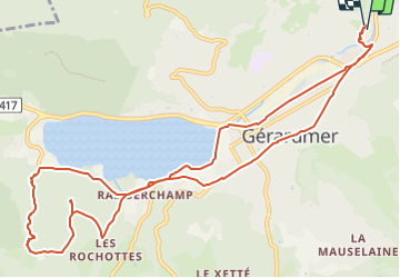
Randonnée Marche de 12,7 km à découvrir à Grand Est, Vosges, Gérardmer. Cette randonnée est proposée par DanielROLLET.
Description
2023 01 08 - 13h15 à 17h05 - Avec Marie
Pluie à l'aller, Temps humide au retour.
Départ/Arrivée depuis la location , 13, chemin des Feutres.
Montée du ruisseau de Mérelle assez raide
Possibilité de faire une boucle par le côté nord du lac.
Localisation
Pays :
France
Région :
Grand Est
Département/Province :
Vosges
Commune :
Gérardmer
Localité :
Unknown
Départ:(Dec)
Départ:(UTM)
342825 ; 5327530 (32U) N.
Commentaires
Randonnées à proximité
![Randonnée Marche Gérardmer - gerardmer - la mauselaine . tête grauvelin . Roche boquet . croix claudé . hautes Vannes . la mauselaine - Photo](https://media.geolcdn.com/t/375/260/52e7d67b-2c25-481b-9a23-f7923e7ada1d.jpg&format=jpg&maxdim=2)
![Marche Marche](https://static1.geolcdn.com/sitytour/trail-icons/101.png)
gerardmer - la mauselaine . tête grauvelin . Roche boquet . croix claudé . ha...
Marche
Très facile
(1)
Gérardmer,
Grand Est,
Vosges,
France
![](/images/other/stat-length.png)
11,3 km | 16,2 km-effort
3h 42min
![](https://static1.geolcdn.com/siteimages/upload/files/16400158638029165_repeat_loop_refresh_sync_direction_icon.png)
Oui
![Randonnée Marche La Bresse - Lac de Lispach et sentier Dielaine - Photo](https://media.geolcdn.com/t/375/260/b54731ea-6209-4cff-b7c0-af5225a4f3ae.jpg&format=jpg&maxdim=2)
![Marche Marche](https://static1.geolcdn.com/sitytour/trail-icons/101.png)
Lac de Lispach et sentier Dielaine
Marche
Moyen
(1)
La Bresse,
Grand Est,
Vosges,
France
![](/images/other/stat-length.png)
9,7 km | 14,9 km-effort
2h 30min
![](https://static1.geolcdn.com/siteimages/upload/files/16400158638029165_repeat_loop_refresh_sync_direction_icon.png)
Oui
![Randonnée Marche nordique Gérardmer - ramonchamp. observatoire de merelle, saut de la bourrique - Photo](https://media.geolcdn.com/t/375/260/b9b6a61e-3e1c-46cb-91c9-2c5e6825ee89.jpg&format=jpg&maxdim=2)
![Marche nordique Marche nordique](https://static1.geolcdn.com/sitytour/trail-icons/102.png)
ramonchamp. observatoire de merelle, saut de la bourrique
Marche nordique
Difficile
(1)
Gérardmer,
Grand Est,
Vosges,
France
![](/images/other/stat-length.png)
11,1 km | 15,8 km-effort
3h 30min
![](https://static1.geolcdn.com/siteimages/upload/files/16400158638029165_repeat_loop_refresh_sync_direction_icon.png)
Oui
![Randonnée Marche La Bresse - lac de Lispach - Photo](https://media.geolcdn.com/t/375/260/ext.jpg?maxdim=2&url=https%3A%2F%2Fservices.sitytrail.com%2FGeolivesWS%2FDownloadMedia.ashx%3FTrailID%3D441673%26Media%3D20150705125536.jpg)
![Marche Marche](https://static1.geolcdn.com/sitytour/trail-icons/101.png)
lac de Lispach
Marche
Facile
(1)
La Bresse,
Grand Est,
Vosges,
France
![](/images/other/stat-length.png)
10,4 km | 14,1 km-effort
4h 6min
![](https://static1.geolcdn.com/siteimages/upload/files/16400158638029165_repeat_loop_refresh_sync_direction_icon.png)
Oui
![Randonnée Marche La Bresse - lac de Lispach - Photo](https://media.geolcdn.com/t/375/260/ext.jpg?maxdim=2&url=https%3A%2F%2Fservices.sitytrail.com%2FGeolivesWS%2FDownloadMedia.ashx%3FTrailID%3D441672%26Media%3D20150705124703.jpg)
![Marche Marche](https://static1.geolcdn.com/sitytour/trail-icons/101.png)
lac de Lispach
Marche
Facile
(3)
La Bresse,
Grand Est,
Vosges,
France
![](/images/other/stat-length.png)
10,4 km | 14,1 km-effort
4h 6min
![](https://static1.geolcdn.com/siteimages/upload/files/16400158638029165_repeat_loop_refresh_sync_direction_icon.png)
Oui
![Randonnée Marche Ban-sur-Meurthe-Clefcy - La vallée de Belbriette - Ban-sur-Meurthe-Clefcy - Photo](https://media.geolcdn.com/t/375/260/ext.jpg?maxdim=2&url=https%3A%2F%2Fservices.sitytrail.com%2FGeolivesWS%2FDownloadMedia.ashx%3FTrailID%3D172951%26Media%3D14431_5.jpg)
![Marche Marche](https://static1.geolcdn.com/sitytour/trail-icons/101.png)
La vallée de Belbriette - Ban-sur-Meurthe-Clefcy
Marche
Moyen
(2)
Ban-sur-Meurthe-Clefcy,
Grand Est,
Vosges,
France
![](/images/other/stat-length.png)
9,8 km | 12,6 km-effort
2h 30min
![](https://static1.geolcdn.com/siteimages/upload/files/16400158638029165_repeat_loop_refresh_sync_direction_icon.png)
Oui
![Randonnée Marche Gérardmer - La Tête de Mérelle - Photo](https://media.geolcdn.com/t/375/260/ext.jpg?maxdim=2&url=https%3A%2F%2Fservices.sitytrail.com%2FGeolivesWS%2FDownloadMedia.ashx%3FTrailID%3D110294%26Media%3D5711_6.jpg)
![Marche Marche](https://static1.geolcdn.com/sitytour/trail-icons/101.png)
La Tête de Mérelle
Marche
Moyen
(5)
Gérardmer,
Grand Est,
Vosges,
France
![](/images/other/stat-length.png)
4,7 km | 9 km-effort
2h 30min
![](https://static1.geolcdn.com/siteimages/upload/files/16400158638029165_repeat_loop_refresh_sync_direction_icon.png)
Oui
![Randonnée Marche Gérardmer - 2018 05 24 obs Merelle - Photo](https://media.geolcdn.com/t/375/260/ext.jpg?maxdim=2&url=https%3A%2F%2Fservices.sitytrail.com%2FGeolivesWS%2FDownloadMedia.ashx%3FTrailID%3D973101%26Media%3Dfix__20180524120350.jpg)
![Marche Marche](https://static1.geolcdn.com/sitytour/trail-icons/101.png)
2018 05 24 obs Merelle
Marche
Moyen
(3)
Gérardmer,
Grand Est,
Vosges,
France
![](/images/other/stat-length.png)
11,5 km | 16,3 km-effort
4h 40min
![](https://static1.geolcdn.com/siteimages/upload/files/16400158638029165_repeat_loop_refresh_sync_direction_icon.png)
Oui
![Randonnée Marche Xonrupt-Longemer - 23-08-17 Lac Longemer - Lispach - Photo](https://media.geolcdn.com/t/375/260/ext.jpg?maxdim=2&url=https%3A%2F%2Fservices.sitytrail.com%2FGeolivesWS%2FDownloadMedia.ashx%3FTrailID%3D815971%26Media%3Dfix__20170823133945.jpg)
![Marche Marche](https://static1.geolcdn.com/sitytour/trail-icons/101.png)
23-08-17 Lac Longemer - Lispach
Marche
Moyen
(1)
Xonrupt-Longemer,
Grand Est,
Vosges,
France
![](/images/other/stat-length.png)
7 km | 12,1 km-effort
2h 13min
![](https://static1.geolcdn.com/siteimages/upload/files/16400158638029165_repeat_loop_refresh_sync_direction_icon.png)
Oui