![](/images/other/stat-length.png)
![Randonnée Marche Noisiel - Parcs de Noisiel & Champs de la gare de Noisiel - Photo](https://media.geolcdn.com/t/1900/400/ext.pjpeg?maxdim=2&url=https%3A%2F%2Fstatic1.geolcdn.com%2Fsiteimages%2Fupload%2Ffiles%2F1553511878bg_sport_marche.png)
Parcs de Noisiel & Champs de la gare de Noisiel
dmj41
Utilisateur
![Longueur](/images/other/stat-length.png)
Longueur
11,3 km
![Altitude max](https://static1.geolcdn.com/siteimages/upload/files/1508320355ic_sort_altitude_max_24dp.png)
Altitude max
105 m
![Dénivelé positif](https://static1.geolcdn.com/siteimages/upload/files/1508320355ic_sort_den_pos_24dp.png)
Dénivelé positif
129 m
![Km-Effort](/images/other/stat-length.png)
Km-Effort
13 km
![Altitude min](https://static1.geolcdn.com/siteimages/upload/files/1508320355ic_sort_altitude_min_24dp.png)
Altitude min
34 m
![Dénivelé négatif](https://static1.geolcdn.com/siteimages/upload/files/1508320355ic_sort_den_neg_24dp.png)
Dénivelé négatif
129 m
![Boucle](https://static1.geolcdn.com/siteimages/upload/files/16400158638029165_repeat_loop_refresh_sync_direction_icon.png)
Boucle
Oui
Date de création :
2023-01-06 15:50:52.633
Dernière modification :
2024-01-29 17:02:04.34
![Marche](https://static1.geolcdn.com/sitytour/trail-icons/101.png)
2h57
Difficulté : Difficile
![Scannez ce code QR pour ouvrir la randonnée dans l'application SityTrail](https://capi.geolives.com/qq0zvz2zws4bq2lad0pu/sitytour/trails/3508799/qr.png?size=200)
Application GPS de randonnée GRATUITE
À propos
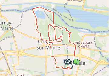
Randonnée Marche de 11,3 km à découvrir à Île-de-France, Seine-et-Marne, Noisiel. Cette randonnée est proposée par dmj41.
Description
Boucle départ/arrivée Gare RER A de Noisiel
Petit circuit (11 kms) en passant par le Parc de Noisiel puis un petit tour dans le parc du château de Champs sur Marne
Localisation
Pays :
France
Région :
Île-de-France
Département/Province :
Seine-et-Marne
Commune :
Noisiel
Localité :
Unknown
Départ:(Dec)
Départ:(UTM)
471836 ; 5410153 (31U) N.
Commentaires
Randonnées à proximité
![Randonnée Marche Émerainville - GRP CV-IDF 13R Emerainville à Marolles-en-Brie - Photo](https://media.geolcdn.com/t/375/260/726621e0-1908-4a49-bd96-d431c02673d0.jpg&format=jpg&maxdim=2)
![Marche Marche](https://static1.geolcdn.com/sitytour/trail-icons/101.png)
GRP CV-IDF 13R Emerainville à Marolles-en-Brie
Marche
Difficile
(1)
Émerainville,
Île-de-France,
Seine-et-Marne,
France
![](/images/other/stat-length.png)
16,8 km | 18,1 km-effort
4h 6min
![](https://static1.geolcdn.com/siteimages/upload/files/16400158638029165_repeat_loop_refresh_sync_direction_icon.png)
Non
![Randonnée Marche Chelles - GRP CV-IDF 12R Chelles à Emerainville - Photo](https://media.geolcdn.com/t/375/260/3e851a57-05bf-470c-9490-37cd07bf40e9.jpg&format=jpg&maxdim=2)
![Marche Marche](https://static1.geolcdn.com/sitytour/trail-icons/101.png)
GRP CV-IDF 12R Chelles à Emerainville
Marche
Moyen
(1)
Chelles,
Île-de-France,
Seine-et-Marne,
France
![](/images/other/stat-length.png)
15 km | 16,7 km-effort
3h 47min
![](https://static1.geolcdn.com/siteimages/upload/files/16400158638029165_repeat_loop_refresh_sync_direction_icon.png)
Non
![Marche Marche](https://static1.geolcdn.com/sitytour/trail-icons/101.png)
JC 09 Du Parc de Rentilly au Ru de la Gondoire
Marche
Difficile
(1)
Saint-Thibault-des-Vignes,
Île-de-France,
Seine-et-Marne,
France
![](/images/other/stat-length.png)
21 km | 24 km-effort
5h 20min
![](https://static1.geolcdn.com/siteimages/upload/files/16400158638029165_repeat_loop_refresh_sync_direction_icon.png)
Oui
![Randonnée Marche Champs-sur-Marne - Boucle 20 km autour de Champs sur Marne - Photo](https://media.geolcdn.com/t/375/260/e5bc49c5-8534-4b14-8b85-21b9437dca8c.jpg&format=jpg&maxdim=2)
![Marche Marche](https://static1.geolcdn.com/sitytour/trail-icons/101.png)
Boucle 20 km autour de Champs sur Marne
Marche
Facile
Champs-sur-Marne,
Île-de-France,
Seine-et-Marne,
France
![](/images/other/stat-length.png)
19,8 km | 22 km-effort
4h 29min
![](https://static1.geolcdn.com/siteimages/upload/files/16400158638029165_repeat_loop_refresh_sync_direction_icon.png)
Oui
![Randonnée Marche Lognes - EvadRando2024-12km - Photo](https://media.geolcdn.com/t/375/260/ext.jpg?maxdim=2&url=https%3A%2F%2Fstatic1.geolcdn.com%2Fsiteimages%2Fupload%2Ffiles%2F1553511878bg_sport_marche.png)
![Marche Marche](https://static1.geolcdn.com/sitytour/trail-icons/101.png)
EvadRando2024-12km
Marche
Difficile
(2)
Lognes,
Île-de-France,
Seine-et-Marne,
France
![](/images/other/stat-length.png)
12,3 km | 14,1 km-effort
3h 12min
![](https://static1.geolcdn.com/siteimages/upload/files/16400158638029165_repeat_loop_refresh_sync_direction_icon.png)
Oui
![Randonnée Marche Lognes - EvadRando2024-17km - Photo](https://media.geolcdn.com/t/375/260/ext.jpg?maxdim=2&url=https%3A%2F%2Fstatic1.geolcdn.com%2Fsiteimages%2Fupload%2Ffiles%2F1553511878bg_sport_marche.png)
![Marche Marche](https://static1.geolcdn.com/sitytour/trail-icons/101.png)
EvadRando2024-17km
Marche
Difficile
(1)
Lognes,
Île-de-France,
Seine-et-Marne,
France
![](/images/other/stat-length.png)
16,7 km | 18,3 km-effort
4h 9min
![](https://static1.geolcdn.com/siteimages/upload/files/16400158638029165_repeat_loop_refresh_sync_direction_icon.png)
Oui
![Randonnée Marche Bussy-Saint-Georges - Boucle Rentilly - Noisiel - Etang de la Brosse - Etang de la Loy - Photo](https://media.geolcdn.com/t/375/260/2ae0fdb4-e8bd-41dd-b6e1-a0c5cc184bfe.jpg&format=jpg&maxdim=2)
![Marche Marche](https://static1.geolcdn.com/sitytour/trail-icons/101.png)
Boucle Rentilly - Noisiel - Etang de la Brosse - Etang de la Loy
Marche
Très difficile
Bussy-Saint-Georges,
Île-de-France,
Seine-et-Marne,
France
![](/images/other/stat-length.png)
25 km | 29 km-effort
6h 32min
![](https://static1.geolcdn.com/siteimages/upload/files/16400158638029165_repeat_loop_refresh_sync_direction_icon.png)
Oui
![Randonnée Marche Vaires-sur-Marne - Boucle Vaires sur Marne / Noisiel / Chelles - Photo](https://media.geolcdn.com/t/375/260/449646ea-4419-47cd-8a7f-7bcc77625a1b.jpg&format=jpg&maxdim=2)
![Marche Marche](https://static1.geolcdn.com/sitytour/trail-icons/101.png)
Boucle Vaires sur Marne / Noisiel / Chelles
Marche
Facile
Vaires-sur-Marne,
Île-de-France,
Seine-et-Marne,
France
![](/images/other/stat-length.png)
21 km | 24 km-effort
4h 33min
![](https://static1.geolcdn.com/siteimages/upload/files/16400158638029165_repeat_loop_refresh_sync_direction_icon.png)
Oui
![Randonnée Marche Lognes - EvadRando2024-14km - Photo](https://media.geolcdn.com/t/375/260/ext.jpg?maxdim=2&url=https%3A%2F%2Fstatic1.geolcdn.com%2Fsiteimages%2Fupload%2Ffiles%2F1553511878bg_sport_marche.png)
![Marche Marche](https://static1.geolcdn.com/sitytour/trail-icons/101.png)
EvadRando2024-14km
Marche
Difficile
(1)
Lognes,
Île-de-France,
Seine-et-Marne,
France
![](/images/other/stat-length.png)
14,3 km | 16,3 km-effort
3h 42min
![](https://static1.geolcdn.com/siteimages/upload/files/16400158638029165_repeat_loop_refresh_sync_direction_icon.png)
Oui