![](/images/other/stat-length.png)
![Randonnée Vélo Meerhout - Zuiderkempen prov. Antwerpen - Photo](https://media.geolcdn.com/t/1900/400/ext.pjpeg?maxdim=2&url=https%3A%2F%2Fservices.sitytrail.com%2FGeolivesWS%2FDownloadMedia.ashx%3FTrailID%3D349421%26Media%3Dfix__20140921142857.jpg)
Zuiderkempen prov. Antwerpen
karawatsj
Utilisateur
![Longueur](/images/other/stat-length.png)
Longueur
88 km
![Altitude max](https://static1.geolcdn.com/siteimages/upload/files/1508320355ic_sort_altitude_max_24dp.png)
Altitude max
48 m
![Dénivelé positif](https://static1.geolcdn.com/siteimages/upload/files/1508320355ic_sort_den_pos_24dp.png)
Dénivelé positif
560 m
![Km-Effort](/images/other/stat-length.png)
Km-Effort
95 km
![Altitude min](https://static1.geolcdn.com/siteimages/upload/files/1508320355ic_sort_altitude_min_24dp.png)
Altitude min
5 m
![Dénivelé négatif](https://static1.geolcdn.com/siteimages/upload/files/1508320355ic_sort_den_neg_24dp.png)
Dénivelé négatif
561 m
![Boucle](https://static1.geolcdn.com/siteimages/upload/files/16400158638029165_repeat_loop_refresh_sync_direction_icon.png)
Boucle
Oui
Date de création :
2014-12-10 00:00:00.0
Dernière modification :
2019-06-04 19:04:41.683
![Vélo](https://static1.geolcdn.com/sitytour/trail-icons/200.png)
6h01
Difficulté : Moyen
![Scannez ce code QR pour ouvrir la randonnée dans l'application SityTrail](https://capi.geolives.com/qq0zvz2zws4bq2lad0pu/sitytour/trails/349421/qr.png?size=200)
Application GPS de randonnée GRATUITE
À propos
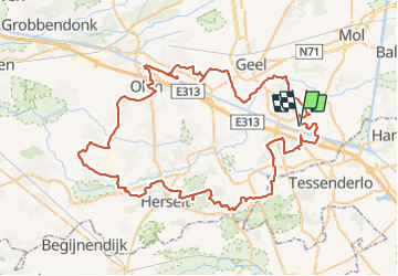
Randonnée Vélo de 88 km à découvrir à Flandre, Anvers, Meerhout. Cette randonnée est proposée par karawatsj.
Description
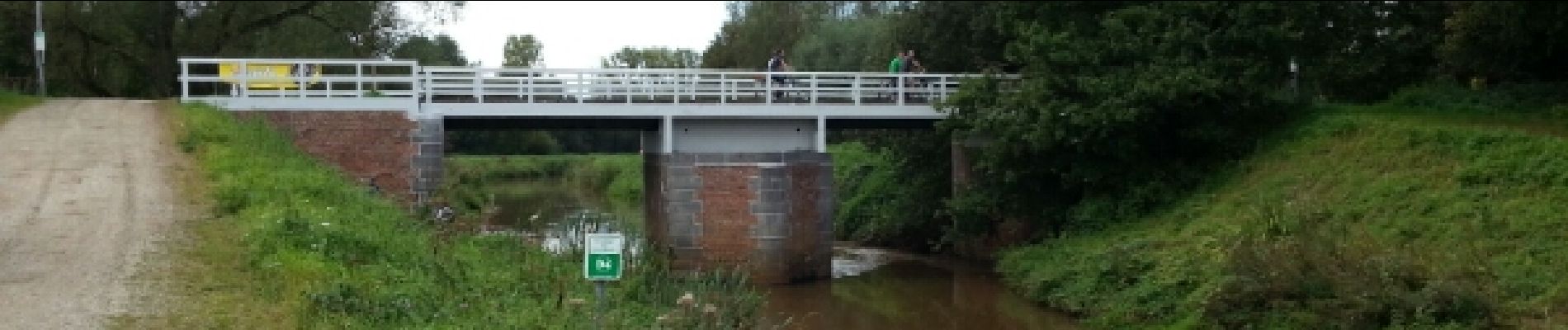
Grotendeels fietsknopennetwerk www.fietsnet.be behalve kleine omleiding op einde wegens werken aan de brug.
45/44/42/08/09/49/69/63/62/65/66/67/42/99/85/94/86/88/17/14/15/20/21/omleiding 46/45
Stuk tussen 65 en 94 is te veel bebouwde kom.
Mie Maan (knooppunt 88) gezellige eetgelegenheid.
Localisation
Pays :
Belgique
Région :
Flandre
Département/Province :
Anvers
Commune :
Meerhout
Localité :
Meerhout
Départ:(Dec)
Départ:(UTM)
643509 ; 5664344 (31U) N.
Commentaires
Randonnées à proximité
![Randonnée Marche Meerhout - Meerhout Ezelspad Geel - 10 km RT - Photo](https://media.geolcdn.com/t/375/260/ext.jpg?maxdim=2&url=https%3A%2F%2Fstatic1.geolcdn.com%2Fsiteimages%2Fupload%2Ffiles%2F1553511878bg_sport_marche.png)
![Marche Marche](https://static1.geolcdn.com/sitytour/trail-icons/101.png)
Meerhout Ezelspad Geel - 10 km RT
Marche
Très facile
(1)
Meerhout,
Flandre,
Anvers,
Belgique
![](/images/other/stat-length.png)
10,1 km | 11,1 km-effort
Inconnu
![](https://static1.geolcdn.com/siteimages/upload/files/16400158638029165_repeat_loop_refresh_sync_direction_icon.png)
Oui
![Randonnée Marche Laakdal - Eindhoutpad - Photo](https://media.geolcdn.com/t/375/260/ext.jpg?maxdim=2&url=https%3A%2F%2Fstatic1.geolcdn.com%2Fsiteimages%2Fupload%2Ffiles%2F1553511878bg_sport_marche.png)
![Marche Marche](https://static1.geolcdn.com/sitytour/trail-icons/101.png)
![Randonnée Vélo Tessenderlo - f-belgie-thorn - Photo](https://media.geolcdn.com/t/375/260/ext.jpg?maxdim=2&url=https%3A%2F%2Fstatic1.geolcdn.com%2Fsiteimages%2Fupload%2Ffiles%2F1524743154velo.jpg)
![Vélo Vélo](https://static1.geolcdn.com/sitytour/trail-icons/200.png)
f-belgie-thorn
Vélo
Très facile
Tessenderlo,
Flandre,
Limbourg,
Belgique
![](/images/other/stat-length.png)
177 km | 191 km-effort
Inconnu
![](https://static1.geolcdn.com/siteimages/upload/files/16400158638029165_repeat_loop_refresh_sync_direction_icon.png)
Oui
![Randonnée Vélo Meerhout - f-belgie-ladiesroute - Photo](https://media.geolcdn.com/t/375/260/ext.jpg?maxdim=2&url=https%3A%2F%2Fstatic1.geolcdn.com%2Fsiteimages%2Fupload%2Ffiles%2F1524743154velo.jpg)
![Vélo Vélo](https://static1.geolcdn.com/sitytour/trail-icons/200.png)
f-belgie-ladiesroute
Vélo
Très facile
Meerhout,
Flandre,
Anvers,
Belgique
![](/images/other/stat-length.png)
52 km | 57 km-effort
Inconnu
![](https://static1.geolcdn.com/siteimages/upload/files/16400158638029165_repeat_loop_refresh_sync_direction_icon.png)
Non
![Randonnée V.T.T. Laakdal - Belgie - MTBtocht Vorst-Laakdal - Photo](https://media.geolcdn.com/t/375/260/ext.jpg?maxdim=2&url=https%3A%2F%2Fstatic1.geolcdn.com%2Fsiteimages%2Fupload%2Ffiles%2F1524743154velo.jpg)
![V.T.T. V.T.T.](https://static1.geolcdn.com/sitytour/trail-icons/202.png)
Belgie - MTBtocht Vorst-Laakdal
V.T.T.
Très facile
Laakdal,
Flandre,
Anvers,
Belgique
![](/images/other/stat-length.png)
38 km | 41 km-effort
Inconnu
![](https://static1.geolcdn.com/siteimages/upload/files/16400158638029165_repeat_loop_refresh_sync_direction_icon.png)
Oui
![Randonnée Marche Meerhout - w-belgie-meerhout-nete-weide-bos - Photo](https://media.geolcdn.com/t/375/260/ext.jpg?maxdim=2&url=https%3A%2F%2Fstatic1.geolcdn.com%2Fsiteimages%2Fupload%2Ffiles%2F1553511878bg_sport_marche.png)
![Marche Marche](https://static1.geolcdn.com/sitytour/trail-icons/101.png)
w-belgie-meerhout-nete-weide-bos
Marche
Très facile
Meerhout,
Flandre,
Anvers,
Belgique
![](/images/other/stat-length.png)
8,3 km | 9 km-effort
Inconnu
![](https://static1.geolcdn.com/siteimages/upload/files/16400158638029165_repeat_loop_refresh_sync_direction_icon.png)
Oui
![Randonnée Marche Meerhout - w-belgie-de-hutten - Photo](https://media.geolcdn.com/t/375/260/ext.jpg?maxdim=2&url=https%3A%2F%2Fstatic1.geolcdn.com%2Fsiteimages%2Fupload%2Ffiles%2F1553511878bg_sport_marche.png)
![Marche Marche](https://static1.geolcdn.com/sitytour/trail-icons/101.png)
w-belgie-de-hutten
Marche
Très facile
Meerhout,
Flandre,
Anvers,
Belgique
![](/images/other/stat-length.png)
16,2 km | 18 km-effort
Inconnu
![](https://static1.geolcdn.com/siteimages/upload/files/16400158638029165_repeat_loop_refresh_sync_direction_icon.png)
Oui
![Randonnée Marche Meerhout - Meerhout Molenwandeling - 14 km RT - Photo](https://media.geolcdn.com/t/375/260/ext.jpg?maxdim=2&url=https%3A%2F%2Fstatic1.geolcdn.com%2Fsiteimages%2Fupload%2Ffiles%2F1553511878bg_sport_marche.png)
![Marche Marche](https://static1.geolcdn.com/sitytour/trail-icons/101.png)
Meerhout Molenwandeling - 14 km RT
Marche
Très facile
Meerhout,
Flandre,
Anvers,
Belgique
![](/images/other/stat-length.png)
14 km | 15,3 km-effort
Inconnu
![](https://static1.geolcdn.com/siteimages/upload/files/16400158638029165_repeat_loop_refresh_sync_direction_icon.png)
Oui
![Randonnée Marche Laakdal - Laakdal Eindhout - 8 km RT - Photo](https://media.geolcdn.com/t/375/260/ext.jpg?maxdim=2&url=https%3A%2F%2Fstatic1.geolcdn.com%2Fsiteimages%2Fupload%2Ffiles%2F1553511878bg_sport_marche.png)
![Marche Marche](https://static1.geolcdn.com/sitytour/trail-icons/101.png)
Laakdal Eindhout - 8 km RT
Marche
Très facile
Laakdal,
Flandre,
Anvers,
Belgique
![](/images/other/stat-length.png)
8 km | 9 km-effort
Inconnu
![](https://static1.geolcdn.com/siteimages/upload/files/16400158638029165_repeat_loop_refresh_sync_direction_icon.png)
Oui