![](/images/other/stat-length.png)
![Randonnée Marche Carqueiranne - la grotte du paradis - Photo](https://media.geolcdn.com/t/1900/400/9486f261-69b8-4de0-9e87-579eb1d901e8.jpg&format=pjpeg&maxdim=2)
la grotte du paradis
cdanielrando
Utilisateur
![Longueur](/images/other/stat-length.png)
Longueur
3,9 km
![Altitude max](https://static1.geolcdn.com/siteimages/upload/files/1508320355ic_sort_altitude_max_24dp.png)
Altitude max
296 m
![Dénivelé positif](https://static1.geolcdn.com/siteimages/upload/files/1508320355ic_sort_den_pos_24dp.png)
Dénivelé positif
197 m
![Km-Effort](/images/other/stat-length.png)
Km-Effort
6,6 km
![Altitude min](https://static1.geolcdn.com/siteimages/upload/files/1508320355ic_sort_altitude_min_24dp.png)
Altitude min
119 m
![Dénivelé négatif](https://static1.geolcdn.com/siteimages/upload/files/1508320355ic_sort_den_neg_24dp.png)
Dénivelé négatif
199 m
![Boucle](https://static1.geolcdn.com/siteimages/upload/files/16400158638029165_repeat_loop_refresh_sync_direction_icon.png)
Boucle
Oui
Date de création :
2022-12-27 08:31:59.916
Dernière modification :
2022-12-27 10:59:51.453
![Marche](https://static1.geolcdn.com/sitytour/trail-icons/101.png)
1h35
Difficulté : Facile
![Scannez ce code QR pour ouvrir la randonnée dans l'application SityTrail](https://capi.geolives.com/qq0zvz2zws4bq2lad0pu/sitytour/trails/3493459/qr.png?size=200)
Application GPS de randonnée GRATUITE
À propos
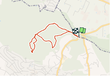
Randonnée Marche de 3,9 km à découvrir à Provence-Alpes-Côte d'Azur, Var, Carqueiranne. Cette randonnée est proposée par cdanielrando.
Description
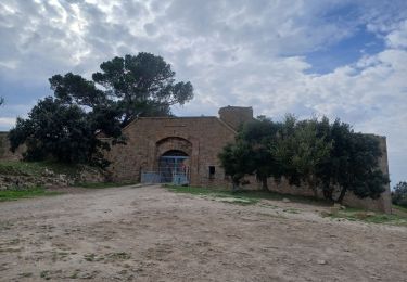
Circuit facile pour découvrir la grotte au sommet de la colline du paradis. Suivre la trace car la carte Ign n'est pas à jour
Localisation
Pays :
France
Région :
Provence-Alpes-Côte d'Azur
Département/Province :
Var
Commune :
Carqueiranne
Localité :
Unknown
Départ:(Dec)
Départ:(UTM)
262903 ; 4776954 (32T) N.
Commentaires
Randonnées à proximité
![Randonnée Marche La Crau - Le Paradis et le mont des oiseaux - Photo](https://media.geolcdn.com/t/375/260/3ea9709f-1bf2-4174-850e-73122825f7f5.jpg&format=jpg&maxdim=2)
![Marche Marche](https://static1.geolcdn.com/sitytour/trail-icons/101.png)
Le Paradis et le mont des oiseaux
Marche
Moyen
(1)
La Crau,
Provence-Alpes-Côte d'Azur,
Var,
France
![](/images/other/stat-length.png)
12,5 km | 19,9 km-effort
6h 30min
![](https://static1.geolcdn.com/siteimages/upload/files/16400158638029165_repeat_loop_refresh_sync_direction_icon.png)
Oui
![Randonnée Marche La Crau - fenouillet Daniel Louis - Photo](https://media.geolcdn.com/t/375/260/74a8e577-0c5f-4f83-9925-bb595eab64a1.jpg&format=jpg&maxdim=2)
![Marche Marche](https://static1.geolcdn.com/sitytour/trail-icons/101.png)
fenouillet Daniel Louis
Marche
Moyen
(1)
La Crau,
Provence-Alpes-Côte d'Azur,
Var,
France
![](/images/other/stat-length.png)
18,1 km | 25 km-effort
4h 36min
![](https://static1.geolcdn.com/siteimages/upload/files/16400158638029165_repeat_loop_refresh_sync_direction_icon.png)
Oui
![Randonnée Marche La Crau - le fenouillet un après-midi d'automne - Photo](https://media.geolcdn.com/t/375/260/ext.jpg?maxdim=2&url=https%3A%2F%2Fservices.sitytrail.com%2FGeolivesWS%2FDownloadMedia.ashx%3FTrailID%3D650501%26Media%3D20161024161101.jpg)
![Marche Marche](https://static1.geolcdn.com/sitytour/trail-icons/101.png)
le fenouillet un après-midi d'automne
Marche
Facile
(2)
La Crau,
Provence-Alpes-Côte d'Azur,
Var,
France
![](/images/other/stat-length.png)
7,6 km | 10,7 km-effort
1h 48min
![](https://static1.geolcdn.com/siteimages/upload/files/16400158638029165_repeat_loop_refresh_sync_direction_icon.png)
Oui
![Randonnée Trail La Crau - Le Fenouillet et château d' Hyères - Photo](https://media.geolcdn.com/t/375/260/b5c97bc5-16a4-4fca-8ec6-5ff57c47ff40.jpg&format=jpg&maxdim=2)
![Trail Trail](https://static1.geolcdn.com/sitytour/trail-icons/104.png)
Le Fenouillet et château d' Hyères
Trail
Moyen
La Crau,
Provence-Alpes-Côte d'Azur,
Var,
France
![](/images/other/stat-length.png)
13,1 km | 18,8 km-effort
2h 9min
![](https://static1.geolcdn.com/siteimages/upload/files/16400158638029165_repeat_loop_refresh_sync_direction_icon.png)
Non
![Randonnée Marche La Crau - Fenouillet - Chateau de Hyères - retour par les vignes - Photo](https://media.geolcdn.com/t/375/260/d2132167-a625-4ff2-ae44-a142bdaeb4e4.jpg&format=jpg&maxdim=2)
![Marche Marche](https://static1.geolcdn.com/sitytour/trail-icons/101.png)
Fenouillet - Chateau de Hyères - retour par les vignes
Marche
Moyen
(2)
La Crau,
Provence-Alpes-Côte d'Azur,
Var,
France
![](/images/other/stat-length.png)
14,1 km | 19,7 km-effort
5h 0min
![](https://static1.geolcdn.com/siteimages/upload/files/16400158638029165_repeat_loop_refresh_sync_direction_icon.png)
Oui
![Randonnée Marche Le Pradet - le Pradet - les trois forts - Photo](https://media.geolcdn.com/t/375/260/f3d5c1c4-abd6-4c30-a189-71ee7c6f2626.jpg&format=jpg&maxdim=2)
![Marche Marche](https://static1.geolcdn.com/sitytour/trail-icons/101.png)
le Pradet - les trois forts
Marche
Très difficile
(2)
Le Pradet,
Provence-Alpes-Côte d'Azur,
Var,
France
![](/images/other/stat-length.png)
13,3 km | 19,6 km-effort
4h 27min
![](https://static1.geolcdn.com/siteimages/upload/files/16400158638029165_repeat_loop_refresh_sync_direction_icon.png)
Oui
![Randonnée A pied Le Pradet - le pradet plage de la garonne la mine - Photo](https://media.geolcdn.com/t/375/260/ext.jpg?maxdim=2&url=https%3A%2F%2Fstatic1.geolcdn.com%2Fsiteimages%2Fupload%2Ffiles%2F1545311037marcheuse_200dpi.jpg)
![A pied A pied](https://static1.geolcdn.com/sitytour/trail-icons/100.png)
le pradet plage de la garonne la mine
A pied
Facile
(1)
Le Pradet,
Provence-Alpes-Côte d'Azur,
Var,
France
![](/images/other/stat-length.png)
6,1 km | 8,2 km-effort
Inconnu
![](https://static1.geolcdn.com/siteimages/upload/files/16400158638029165_repeat_loop_refresh_sync_direction_icon.png)
Oui
![Randonnée Marche Le Pradet - les 3 forts depuis la plage de la Garonne - Photo](https://media.geolcdn.com/t/375/260/1cc1b5b0-8fc0-47a1-b418-a51de495ba7d.jpg&format=jpg&maxdim=2)
![Marche Marche](https://static1.geolcdn.com/sitytour/trail-icons/101.png)
les 3 forts depuis la plage de la Garonne
Marche
Très difficile
Le Pradet,
Provence-Alpes-Côte d'Azur,
Var,
France
![](/images/other/stat-length.png)
16,7 km | 24 km-effort
3h 59min
![](https://static1.geolcdn.com/siteimages/upload/files/16400158638029165_repeat_loop_refresh_sync_direction_icon.png)
Oui
![Randonnée Marche Le Pradet - Mine de la Garonne 2-18-10-2024 - Photo](https://media.geolcdn.com/t/375/260/eb51cf3e-5952-413e-b535-93de1e3f672e.jpg&format=jpg&maxdim=2)
![Marche Marche](https://static1.geolcdn.com/sitytour/trail-icons/101.png)
Mine de la Garonne 2-18-10-2024
Marche
Facile
Le Pradet,
Provence-Alpes-Côte d'Azur,
Var,
France
![](/images/other/stat-length.png)
7,2 km | 9,6 km-effort
1h 55min
![](https://static1.geolcdn.com/siteimages/upload/files/16400158638029165_repeat_loop_refresh_sync_direction_icon.png)
Oui
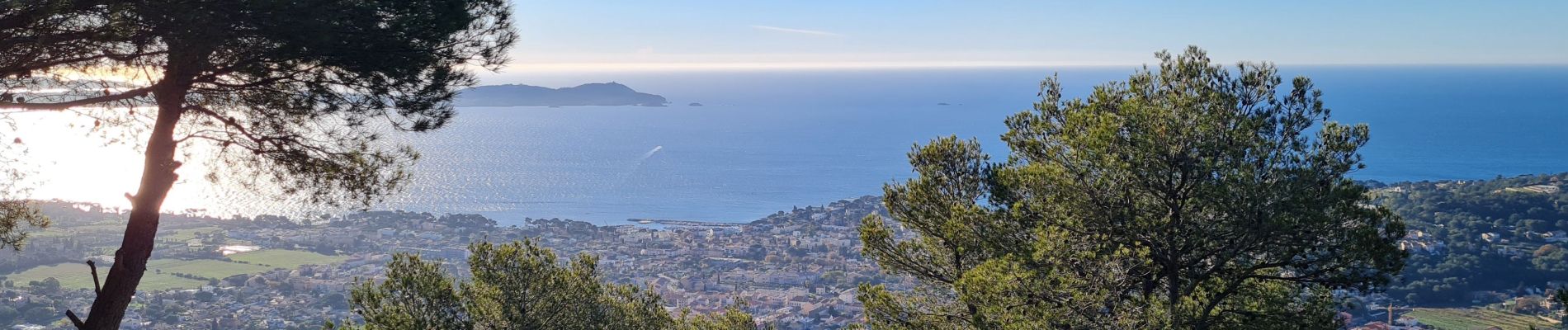
beau dénivelé et belle récompense 😎🤩