![](/images/other/stat-length.png)
![Randonnée Marche La Bégude-de-Mazenc - Serre Forillon . La Begude de Mazenc 8km - Photo](https://media.geolcdn.com/t/1900/400/c6c6d47d-2b27-4a95-a6a2-66f0defa82f3.jpg&format=pjpeg&maxdim=2)
Serre Forillon . La Begude de Mazenc 8km
chancha
Utilisateur GUIDE
![Longueur](/images/other/stat-length.png)
Longueur
8,3 km
![Altitude max](https://static1.geolcdn.com/siteimages/upload/files/1508320355ic_sort_altitude_max_24dp.png)
Altitude max
467 m
![Dénivelé positif](https://static1.geolcdn.com/siteimages/upload/files/1508320355ic_sort_den_pos_24dp.png)
Dénivelé positif
295 m
![Km-Effort](/images/other/stat-length.png)
Km-Effort
12,3 km
![Altitude min](https://static1.geolcdn.com/siteimages/upload/files/1508320355ic_sort_altitude_min_24dp.png)
Altitude min
211 m
![Dénivelé négatif](https://static1.geolcdn.com/siteimages/upload/files/1508320355ic_sort_den_neg_24dp.png)
Dénivelé négatif
295 m
![Boucle](https://static1.geolcdn.com/siteimages/upload/files/16400158638029165_repeat_loop_refresh_sync_direction_icon.png)
Boucle
Oui
Date de création :
2022-12-16 07:55:45.944
Dernière modification :
2023-01-20 11:21:31.281
![Marche](https://static1.geolcdn.com/sitytour/trail-icons/101.png)
2h44
Difficulté : Difficile
![Scannez ce code QR pour ouvrir la randonnée dans l'application SityTrail](https://capi.geolives.com/qq0zvz2zws4bq2lad0pu/sitytour/trails/3482251/qr.png?size=200)
Application GPS de randonnée GRATUITE
À propos
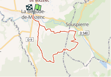
Randonnée Marche de 8,3 km à découvrir à Auvergne-Rhône-Alpes, Drôme, La Bégude-de-Mazenc. Cette randonnée est proposée par chancha.
Description
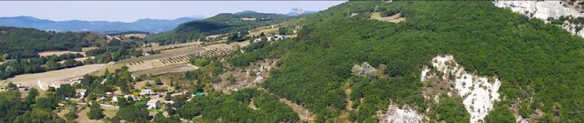
Une boucle variée au-dessus de la Bégude avec de beaux points de vue notamment depuis le belvédère du Serre de Forillon. Si l’ensemble est relativement facile, quelques montées un peu raides demanderont un petit effort au promeneur.
Localisation
Pays :
France
Région :
Auvergne-Rhône-Alpes
Département/Province :
Drôme
Commune :
La Bégude-de-Mazenc
Localité :
Unknown
Départ:(Dec)
Départ:(UTM)
653730 ; 4934210 (31T) N.
Commentaires
Randonnées à proximité
![Randonnée Marche Portes-en-Valdaine - Portes-en-Valdaine : Fournat et Chatelard 10km - Photo](https://media.geolcdn.com/t/375/260/2ea09867-c31b-46c1-94ae-201697a2583c.jpg&format=jpg&maxdim=2)
![Marche Marche](https://static1.geolcdn.com/sitytour/trail-icons/101.png)
Portes-en-Valdaine : Fournat et Chatelard 10km
Marche
Moyen
(1)
Portes-en-Valdaine,
Auvergne-Rhône-Alpes,
Drôme,
France
![](/images/other/stat-length.png)
9,8 km | 13,6 km-effort
3h 2min
![](https://static1.geolcdn.com/siteimages/upload/files/16400158638029165_repeat_loop_refresh_sync_direction_icon.png)
Oui
![Randonnée Marche Portes-en-Valdaine - Portes-en-Valdaine Serre-de-Mirabel 11km. - Photo](https://media.geolcdn.com/t/375/260/89334076-0011-4fd6-a9cb-db05a56205b4.jpg&format=jpg&maxdim=2)
![Marche Marche](https://static1.geolcdn.com/sitytour/trail-icons/101.png)
Portes-en-Valdaine Serre-de-Mirabel 11km.
Marche
Difficile
(1)
Portes-en-Valdaine,
Auvergne-Rhône-Alpes,
Drôme,
France
![](/images/other/stat-length.png)
10,8 km | 14,7 km-effort
3h 20min
![](https://static1.geolcdn.com/siteimages/upload/files/16400158638029165_repeat_loop_refresh_sync_direction_icon.png)
Oui
![Randonnée Marche Saint-Gervais-sur-Roubion - Moutette-St-Rome-STGervais 10km - Photo](https://media.geolcdn.com/t/375/260/6b20cd10-00dc-411b-8b77-04281c5b5149.jpg&format=jpg&maxdim=2)
![Marche Marche](https://static1.geolcdn.com/sitytour/trail-icons/101.png)
Moutette-St-Rome-STGervais 10km
Marche
Moyen
(1)
Saint-Gervais-sur-Roubion,
Auvergne-Rhône-Alpes,
Drôme,
France
![](/images/other/stat-length.png)
9,9 km | 11,9 km-effort
2h 43min
![](https://static1.geolcdn.com/siteimages/upload/files/16400158638029165_repeat_loop_refresh_sync_direction_icon.png)
Oui
![Randonnée Marche Portes-en-Valdaine - Portes en Valdaine la plaine 7km - Photo](https://media.geolcdn.com/t/375/260/521ae53d-ced6-46fa-9655-4eb3952c25ee.jpg&format=jpg&maxdim=2)
![Marche Marche](https://static1.geolcdn.com/sitytour/trail-icons/101.png)
Portes en Valdaine la plaine 7km
Marche
Facile
(1)
Portes-en-Valdaine,
Auvergne-Rhône-Alpes,
Drôme,
France
![](/images/other/stat-length.png)
7,1 km | 8,2 km-effort
2h 0min
![](https://static1.geolcdn.com/siteimages/upload/files/16400158638029165_repeat_loop_refresh_sync_direction_icon.png)
Oui
![Randonnée Marche La Touche - La Touche Crêtes de l'ysard 12km. - Photo](https://media.geolcdn.com/t/375/260/b7717e93-9def-4e5d-8328-3e96528d5925.jpg&format=jpg&maxdim=2)
![Marche Marche](https://static1.geolcdn.com/sitytour/trail-icons/101.png)
La Touche Crêtes de l'ysard 12km.
Marche
Difficile
(1)
La Touche,
Auvergne-Rhône-Alpes,
Drôme,
France
![](/images/other/stat-length.png)
12,1 km | 16,8 km-effort
3h 48min
![](https://static1.geolcdn.com/siteimages/upload/files/16400158638029165_repeat_loop_refresh_sync_direction_icon.png)
Oui
![Randonnée Marche La Touche - La Touche : Les Citelles et Serre Pointu 12km - Photo](https://media.geolcdn.com/t/375/260/6be75cc0-9945-4cf3-b3f9-69a08db1d316.jpg&format=jpg&maxdim=2)
![Marche Marche](https://static1.geolcdn.com/sitytour/trail-icons/101.png)
La Touche : Les Citelles et Serre Pointu 12km
Marche
Difficile
La Touche,
Auvergne-Rhône-Alpes,
Drôme,
France
![](/images/other/stat-length.png)
12 km | 16,6 km-effort
4h 3min
![](https://static1.geolcdn.com/siteimages/upload/files/16400158638029165_repeat_loop_refresh_sync_direction_icon.png)
Oui
![Randonnée Marche La Touche - La Touche Mastaize 9km - Photo](https://media.geolcdn.com/t/375/260/7617f59d-4270-4583-9eab-9f2081c0076a.jpg&format=jpg&maxdim=2)
![Marche Marche](https://static1.geolcdn.com/sitytour/trail-icons/101.png)
La Touche Mastaize 9km
Marche
Difficile
La Touche,
Auvergne-Rhône-Alpes,
Drôme,
France
![](/images/other/stat-length.png)
8,6 km | 10,7 km-effort
3h 24min
![](https://static1.geolcdn.com/siteimages/upload/files/16400158638029165_repeat_loop_refresh_sync_direction_icon.png)
Oui
![Randonnée Marche Portes-en-Valdaine - 26 portes en valdaine - Photo](https://media.geolcdn.com/t/375/260/b3cf4f19-20f2-4a60-8f05-2283f4c73166.jpg&format=jpg&maxdim=2)
![Marche Marche](https://static1.geolcdn.com/sitytour/trail-icons/101.png)
26 portes en valdaine
Marche
Très facile
Portes-en-Valdaine,
Auvergne-Rhône-Alpes,
Drôme,
France
![](/images/other/stat-length.png)
10,6 km | 14,5 km-effort
4h 10min
![](https://static1.geolcdn.com/siteimages/upload/files/16400158638029165_repeat_loop_refresh_sync_direction_icon.png)
Oui
![Randonnée Marche La Touche - Citelles hameau et ruisseaux 10km - Photo](https://media.geolcdn.com/t/375/260/ae07cd43-efe5-443c-ada6-328c965bd163.jpg&format=jpg&maxdim=2)
![Marche Marche](https://static1.geolcdn.com/sitytour/trail-icons/101.png)
Citelles hameau et ruisseaux 10km
Marche
Facile
(2)
La Touche,
Auvergne-Rhône-Alpes,
Drôme,
France
![](/images/other/stat-length.png)
9,6 km | 12,6 km-effort
3h 7min
![](https://static1.geolcdn.com/siteimages/upload/files/16400158638029165_repeat_loop_refresh_sync_direction_icon.png)
Oui