![](/images/other/stat-length.png)
![Randonnée Marche Lourdes - LOURDES -Le Pic du JER- G3 -10 km-593m-MD - Photo](https://media.geolcdn.com/t/1900/400/ext.pjpeg?maxdim=2&url=https%3A%2F%2Fstatic1.geolcdn.com%2Fsiteimages%2Fupload%2Ffiles%2F1553511878bg_sport_marche.png)
LOURDES -Le Pic du JER- G3 -10 km-593m-MD
mitch1952
Utilisateur
![Longueur](/images/other/stat-length.png)
Longueur
10,1 km
![Altitude max](https://static1.geolcdn.com/siteimages/upload/files/1508320355ic_sort_altitude_max_24dp.png)
Altitude max
942 m
![Dénivelé positif](https://static1.geolcdn.com/siteimages/upload/files/1508320355ic_sort_den_pos_24dp.png)
Dénivelé positif
593 m
![Km-Effort](/images/other/stat-length.png)
Km-Effort
18 km
![Altitude min](https://static1.geolcdn.com/siteimages/upload/files/1508320355ic_sort_altitude_min_24dp.png)
Altitude min
399 m
![Dénivelé négatif](https://static1.geolcdn.com/siteimages/upload/files/1508320355ic_sort_den_neg_24dp.png)
Dénivelé négatif
593 m
![Boucle](https://static1.geolcdn.com/siteimages/upload/files/16400158638029165_repeat_loop_refresh_sync_direction_icon.png)
Boucle
Oui
Date de création :
2022-12-15 16:43:44.588
Dernière modification :
2022-12-15 18:12:28.489
![Marche](https://static1.geolcdn.com/sitytour/trail-icons/101.png)
5h30
Difficulté : Difficile
![Scannez ce code QR pour ouvrir la randonnée dans l'application SityTrail](https://capi.geolives.com/qq0zvz2zws4bq2lad0pu/sitytour/trails/3481906/qr.png?size=200)
Application GPS de randonnée GRATUITE
À propos
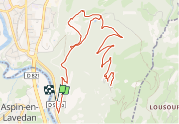
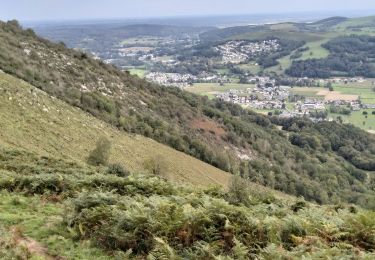
Randonnée Marche de 10,1 km à découvrir à Occitanie, Hautes-Pyrénées, Lourdes. Cette randonnée est proposée par mitch1952.
Description
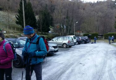
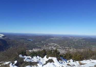
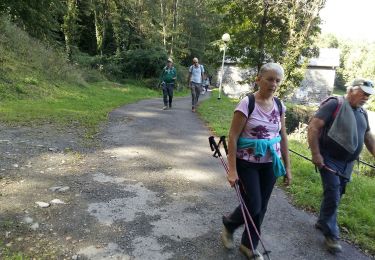
Pic de Ger en G3 en quasi A/R le départ se faisant sur le parking de la route de Lugagnan. C'est une variante légèrement plus courte de 2 km et avec 150 m de dénivelé en moins comparé au G2 classique du LPC.
Localisation
Pays :
France
Région :
Occitanie
Département/Province :
Hautes-Pyrénées
Commune :
Lourdes
Localité :
Unknown
Départ:(Dec)
Départ:(UTM)
740911 ; 4773676 (30T) N.
Commentaires
Randonnées à proximité
![Randonnée Marche Ségus - col du pré du roi par segus reconnu - Photo](https://media.geolcdn.com/t/375/260/8a292310-c3a3-4003-ab0e-617cb49dc561.jpg&format=jpg&maxdim=2)
![Marche Marche](https://static1.geolcdn.com/sitytour/trail-icons/101.png)
col du pré du roi par segus reconnu
Marche
Difficile
(1)
Ségus,
Occitanie,
Hautes-Pyrénées,
France
![](/images/other/stat-length.png)
10,4 km | 16,8 km-effort
3h 49min
![](https://static1.geolcdn.com/siteimages/upload/files/16400158638029165_repeat_loop_refresh_sync_direction_icon.png)
Oui
![Randonnée Marche Ousté - SAINT CRÉAC le soum de Trémou reco - Photo](https://media.geolcdn.com/t/375/260/a98a900a-30ee-4911-939d-ee970c5781d5.jpg&format=jpg&maxdim=2)
![Marche Marche](https://static1.geolcdn.com/sitytour/trail-icons/101.png)
SAINT CRÉAC le soum de Trémou reco
Marche
Difficile
Ousté,
Occitanie,
Hautes-Pyrénées,
France
![](/images/other/stat-length.png)
11,2 km | 18,8 km-effort
3h 41min
![](https://static1.geolcdn.com/siteimages/upload/files/16400158638029165_repeat_loop_refresh_sync_direction_icon.png)
Oui
![Randonnée Cheval Lourdes - GERMS SUR L'OUSSOUET - Photo](https://media.geolcdn.com/t/375/260/ext.jpg?maxdim=2&url=https%3A%2F%2Fstatic1.geolcdn.com%2Fsiteimages%2Fupload%2Ffiles%2F1524743154cheval.jpg)
![Cheval Cheval](https://static1.geolcdn.com/sitytour/trail-icons/300.png)
GERMS SUR L'OUSSOUET
Cheval
Facile
(1)
Lourdes,
Occitanie,
Hautes-Pyrénées,
France
![](/images/other/stat-length.png)
18 km | 26 km-effort
3h 19min
![](https://static1.geolcdn.com/siteimages/upload/files/16400158638029165_repeat_loop_refresh_sync_direction_icon.png)
Non
![Randonnée Marche Lourdes - 2023 10 09 CHEMIN du PIÉMONT PYRÉNÉEN - 17ème étape : Lourdes - Saint-Pé-de Bigorre - Lestelle-Bétharram - Photo](https://media.geolcdn.com/t/375/260/442ca37b-5bdb-4d68-8d03-9f9f787ba05d.jpg&format=jpg&maxdim=2)
![Marche Marche](https://static1.geolcdn.com/sitytour/trail-icons/101.png)
2023 10 09 CHEMIN du PIÉMONT PYRÉNÉEN - 17ème étape : Lourdes - Saint-Pé-de B...
Marche
Moyen
Lourdes,
Occitanie,
Hautes-Pyrénées,
France
![](/images/other/stat-length.png)
17,5 km | 22 km-effort
4h 47min
![](https://static1.geolcdn.com/siteimages/upload/files/16400158638029165_repeat_loop_refresh_sync_direction_icon.png)
Non
![Randonnée Marche Lourdes - 65-lourdes-pic-jer-via-AYNE-14km-450m - Photo](https://media.geolcdn.com/t/375/260/edfe9827-bfa7-45cb-8900-3f3f61682c3a.jpg&format=jpg&maxdim=2)
![Marche Marche](https://static1.geolcdn.com/sitytour/trail-icons/101.png)
65-lourdes-pic-jer-via-AYNE-14km-450m
Marche
Moyen
Lourdes,
Occitanie,
Hautes-Pyrénées,
France
![](/images/other/stat-length.png)
14,9 km | 23 km-effort
4h 37min
![](https://static1.geolcdn.com/siteimages/upload/files/16400158638029165_repeat_loop_refresh_sync_direction_icon.png)
Non
![Randonnée Marche Lourdes - LOURDES la boucle du petit Jer G4](https://media.geolcdn.com/t/375/260/b5657c6d-2945-414a-9faa-597eb5ff020c.jpg&format=jpg&maxdim=2)
![Marche Marche](https://static1.geolcdn.com/sitytour/trail-icons/101.png)
LOURDES la boucle du petit Jer G4 "3539541"
Marche
Moyen
(1)
Lourdes,
Occitanie,
Hautes-Pyrénées,
France
![](/images/other/stat-length.png)
7,2 km | 11,2 km-effort
2h 28min
![](https://static1.geolcdn.com/siteimages/upload/files/16400158638029165_repeat_loop_refresh_sync_direction_icon.png)
Oui
![Randonnée Marche Saint-Créac - SAINT CRÉAC soum de Tremou BF de Guy G3 - Photo](https://media.geolcdn.com/t/375/260/9d594086-7588-47fe-9248-f3484a1a71e9.jpg&format=jpg&maxdim=2)
![Marche Marche](https://static1.geolcdn.com/sitytour/trail-icons/101.png)
SAINT CRÉAC soum de Tremou BF de Guy G3
Marche
Difficile
Saint-Créac,
Occitanie,
Hautes-Pyrénées,
France
![](/images/other/stat-length.png)
11 km | 18,6 km-effort
3h 51min
![](https://static1.geolcdn.com/siteimages/upload/files/16400158638029165_repeat_loop_refresh_sync_direction_icon.png)
Oui
![Randonnée Marche Lourdes - Pic du Jer - Photo](https://media.geolcdn.com/t/375/260/2ec92ca4-bc0f-4457-b492-963919b92b1f.jpg&format=jpg&maxdim=2)
![Marche Marche](https://static1.geolcdn.com/sitytour/trail-icons/101.png)
Pic du Jer
Marche
Très difficile
Lourdes,
Occitanie,
Hautes-Pyrénées,
France
![](/images/other/stat-length.png)
13,5 km | 21 km-effort
4h 28min
![](https://static1.geolcdn.com/siteimages/upload/files/16400158638029165_repeat_loop_refresh_sync_direction_icon.png)
Oui
![Randonnée Marche Lourdes - LOURDES le Beout autrement 2955824 - Photo](https://media.geolcdn.com/t/375/260/988997aa-10d6-47b9-8be8-5078e4de55b9.jpg&format=jpg&maxdim=2)
![Marche Marche](https://static1.geolcdn.com/sitytour/trail-icons/101.png)
LOURDES le Beout autrement 2955824
Marche
Difficile
Lourdes,
Occitanie,
Hautes-Pyrénées,
France
![](/images/other/stat-length.png)
9,6 km | 15,3 km-effort
5h 50min
![](https://static1.geolcdn.com/siteimages/upload/files/16400158638029165_repeat_loop_refresh_sync_direction_icon.png)
Non