![](/images/other/stat-length.png)
![Randonnée Marche Neupré - Neupré - Balade du Chemin des morts - Photo](https://media.geolcdn.com/t/1900/400/ext.pjpeg?maxdim=2&url=https%3A%2F%2Fstatic1.geolcdn.com%2Fsiteimages%2Fupload%2Ffiles%2F1553511878bg_sport_marche.png)
Neupré - Balade du Chemin des morts
Commune de Neupré
Randonnées de la Commune de Neupré PRO
![Longueur](/images/other/stat-length.png)
Longueur
5,1 km
![Altitude max](https://static1.geolcdn.com/siteimages/upload/files/1508320355ic_sort_altitude_max_24dp.png)
Altitude max
214 m
![Dénivelé positif](https://static1.geolcdn.com/siteimages/upload/files/1508320355ic_sort_den_pos_24dp.png)
Dénivelé positif
171 m
![Km-Effort](/images/other/stat-length.png)
Km-Effort
7,4 km
![Altitude min](https://static1.geolcdn.com/siteimages/upload/files/1508320355ic_sort_altitude_min_24dp.png)
Altitude min
117 m
![Dénivelé négatif](https://static1.geolcdn.com/siteimages/upload/files/1508320355ic_sort_den_neg_24dp.png)
Dénivelé négatif
171 m
![Boucle](https://static1.geolcdn.com/siteimages/upload/files/16400158638029165_repeat_loop_refresh_sync_direction_icon.png)
Boucle
Oui
Date de création :
2014-12-10 00:00:00.0
Dernière modification :
2014-12-10 00:00:00.0
![Marche](https://static1.geolcdn.com/sitytour/trail-icons/101.png)
1h33
Difficulté : Moyen
![Scannez ce code QR pour ouvrir la randonnée dans l'application SityTrail](https://capi.geolives.com/qq0zvz2zws4bq2lad0pu/sitytour/trails/347367/qr.png?size=200)
Application GPS de randonnée GRATUITE
À propos
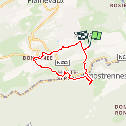
Randonnée Marche de 5,1 km à découvrir à Wallonie, Liège, Neupré. Cette randonnée est proposée par Commune de Neupré.
Description
Petite randonnée sportive entre les hameaux de Strivay, Bonsgnée et Houte-si-Plout à travers prés et bois.
Points d'intérêt
Localisation
Pays :
Belgique
Région :
Wallonie
Département/Province :
Liège
Commune :
Neupré
Localité :
Plainevaux
Départ:(Dec)
Départ:(UTM)
679780 ; 5601113 (31U) N.
Commentaires
Randonnées à proximité
![Randonnée Marche Esneux - Esneux bois du mary - Photo](https://media.geolcdn.com/t/375/260/71c77441-f9b7-4220-bb0a-fbf9c3317653.jpg&format=jpg&maxdim=2)
![Marche Marche](https://static1.geolcdn.com/sitytour/trail-icons/101.png)
Esneux bois du mary
Marche
Facile
(5)
Esneux,
Wallonie,
Liège,
Belgique
![](/images/other/stat-length.png)
4,4 km | 5,9 km-effort
1h 11min
![](https://static1.geolcdn.com/siteimages/upload/files/16400158638029165_repeat_loop_refresh_sync_direction_icon.png)
Oui
![Randonnée Marche Esneux - RB-Lg-20_Tilff - Photo](https://media.geolcdn.com/t/375/260/ext.jpg?maxdim=2&url=https%3A%2F%2Fservices.sitytrail.com%2FGeolivesWS%2FDownloadMedia.ashx%3FTrailID%3D400739%26Media%3D2cb4df8e-af53-4650-9797-54389fe3086f.jpg)
![Marche Marche](https://static1.geolcdn.com/sitytour/trail-icons/101.png)
RB-Lg-20_Tilff
Marche
Très difficile
(7)
Esneux,
Wallonie,
Liège,
Belgique
![](/images/other/stat-length.png)
20 km | 28 km-effort
6h 21min
![](https://static1.geolcdn.com/siteimages/upload/files/16400158638029165_repeat_loop_refresh_sync_direction_icon.png)
Oui
![Randonnée Marche Anthisnes - RB-Lg-18_Tavier - Photo](https://media.geolcdn.com/t/375/260/ext.jpg?maxdim=2&url=https%3A%2F%2Fservices.sitytrail.com%2FGeolivesWS%2FDownloadMedia.ashx%3FTrailID%3D400569%26Media%3D8137f08d-271c-4dcb-b2bd-96adf6706999.jpg)
![Marche Marche](https://static1.geolcdn.com/sitytour/trail-icons/101.png)
RB-Lg-18_Tavier
Marche
Très difficile
(10)
Anthisnes,
Wallonie,
Liège,
Belgique
![](/images/other/stat-length.png)
22 km | 28 km-effort
6h 19min
![](https://static1.geolcdn.com/siteimages/upload/files/16400158638029165_repeat_loop_refresh_sync_direction_icon.png)
Oui
![Randonnée Marche Neupré - Neupré - liaisons inter-hameaux et -villages - Photo](https://media.geolcdn.com/t/375/260/ext.jpg?maxdim=2&url=https%3A%2F%2Fservices.sitytrail.com%2FGeolivesWS%2FDownloadMedia.ashx%3FTrailID%3D347446%26Media%3Dfix__20140903123425.jpg)
![Marche Marche](https://static1.geolcdn.com/sitytour/trail-icons/101.png)
Neupré - liaisons inter-hameaux et -villages
Marche
Moyen
(13)
Neupré,
Wallonie,
Liège,
Belgique
![](/images/other/stat-length.png)
10,8 km | 14,1 km-effort
2h 59min
![](https://static1.geolcdn.com/siteimages/upload/files/16400158638029165_repeat_loop_refresh_sync_direction_icon.png)
Oui
![Randonnée Marche Neupré - Neupré - les contreforts de la Boucle de l'Ourthe - Photo](https://media.geolcdn.com/t/375/260/ext.jpg?maxdim=2&url=https%3A%2F%2Fservices.sitytrail.com%2FGeolivesWS%2FDownloadMedia.ashx%3FTrailID%3D347434%26Media%3Dfix__20140909180027.jpg)
![Marche Marche](https://static1.geolcdn.com/sitytour/trail-icons/101.png)
Neupré - les contreforts de la Boucle de l'Ourthe
Marche
Moyen
(18)
Neupré,
Wallonie,
Liège,
Belgique
![](/images/other/stat-length.png)
7,9 km | 10,9 km-effort
2h 21min
![](https://static1.geolcdn.com/siteimages/upload/files/16400158638029165_repeat_loop_refresh_sync_direction_icon.png)
Oui
![Randonnée Marche Esneux - RB-Lg-10_Esneux_via-racc - Photo](https://media.geolcdn.com/t/375/260/ext.jpg?maxdim=2&url=https%3A%2F%2Fservices.sitytrail.com%2FGeolivesWS%2FDownloadMedia.ashx%3FTrailID%3D209422%26Media%3D464c3dd7-df43-4893-8019-c771f2bd17f1.jpg)
![Marche Marche](https://static1.geolcdn.com/sitytour/trail-icons/101.png)
RB-Lg-10_Esneux_via-racc
Marche
Difficile
(7)
Esneux,
Wallonie,
Liège,
Belgique
![](/images/other/stat-length.png)
11 km | 15,1 km-effort
3h 26min
![](https://static1.geolcdn.com/siteimages/upload/files/16400158638029165_repeat_loop_refresh_sync_direction_icon.png)
Oui
![Randonnée Marche Esneux - RB-Lg-10_Esneux - Photo](https://media.geolcdn.com/t/375/260/ext.jpg?maxdim=2&url=https%3A%2F%2Fservices.sitytrail.com%2FGeolivesWS%2FDownloadMedia.ashx%3FTrailID%3D179568%26Media%3D18c2b0fe-ccb1-462d-9e89-f89259226c52.jpg)
![Marche Marche](https://static1.geolcdn.com/sitytour/trail-icons/101.png)
RB-Lg-10_Esneux
Marche
Très difficile
(21)
Esneux,
Wallonie,
Liège,
Belgique
![](/images/other/stat-length.png)
21 km | 29 km-effort
6h 32min
![](https://static1.geolcdn.com/siteimages/upload/files/16400158638029165_repeat_loop_refresh_sync_direction_icon.png)
Oui
![Randonnée Marche Neupré - Neupré - balade de Rotheux - Photo](https://media.geolcdn.com/t/375/260/ext.jpg?maxdim=2&url=https%3A%2F%2Fservices.sitytrail.com%2FGeolivesWS%2FDownloadMedia.ashx%3FTrailID%3D347399%26Media%3D32c01f91-c180-4d53-8d7d-a74522876cd8.JPG)
![Marche Marche](https://static1.geolcdn.com/sitytour/trail-icons/101.png)
Neupré - balade de Rotheux
Marche
Moyen
(11)
Neupré,
Wallonie,
Liège,
Belgique
![](/images/other/stat-length.png)
8,7 km | 11,1 km-effort
2h 21min
![](https://static1.geolcdn.com/siteimages/upload/files/16400158638029165_repeat_loop_refresh_sync_direction_icon.png)
Oui
![Randonnée Marche Neupré - Neupré - Sentier Paysage et Géologie - Photo](https://media.geolcdn.com/t/375/260/ext.jpg?maxdim=2&url=https%3A%2F%2Fservices.sitytrail.com%2FGeolivesWS%2FDownloadMedia.ashx%3FTrailID%3D343711%26Media%3Dfix__20140909182657.jpg)
![Marche Marche](https://static1.geolcdn.com/sitytour/trail-icons/101.png)
Neupré - Sentier Paysage et Géologie
Marche
Facile
(9)
Neupré,
Wallonie,
Liège,
Belgique
![](/images/other/stat-length.png)
2,7 km | 3,6 km-effort
50min
![](https://static1.geolcdn.com/siteimages/upload/files/16400158638029165_repeat_loop_refresh_sync_direction_icon.png)
Oui
après la prairie,au3e kms, descente impossible vers grand route donc poursuivre chemin et retraverser la grand route comme à l aller pour rejoindre strivay
on passe par 3 routes dangereuse, une prairie privée et un terrain privé. les sentiers ne semblent plus être tous présent...
belle balade, essentiellement sur les chemins et dans les bois qui nous donne un autre apercu de Neupre.
balade sympa prévoir chaussures qui ne craignent pas la boue
Belle balade dans la nature et beaux paysages ??
Chouette balade mais une partie du chemin (après la Coccinelle) est occupée par le ruisseau.
belle promenade malgré les quelques chemins non praticables. 2 gués et 1 barrage de castor
belle promenade mis à part les quelques chemins à nettoyer pour que ce soit praticable. petit gué et barrage de castor à passer