Randonnée A pied La Chapelle-de-Guinchay - La Chapelle de Guinchay 29-11-2022 - Photo
 Bcomb
Bcomb

Utilisateur

© OpenStreetMap contributors
Longueur
Longueur
9,4 km
Altitude max
Altitude max
276 m
Dénivelé positif
Dénivelé positif
109 m
Km-Effort
Km-Effort  
10,9 km
Altitude min
Altitude min
202 m
Dénivelé négatif
Dénivelé négatif
109 m
Boucle
Boucle
Oui
Date de création :
2022-12-02 08:50:09.625
Dernière modification :
2022-12-02 09:28:11.792

(0 Avis)

A pied
A pied
2h28
Difficulté : Facile

Scannez ce code QR pour ouvrir la randonnée dans l'application SityTrail

Application GPS de randonnée GRATUITE

Logo SityTrail SityTrail

IGN / Instituts géographiques

Télécharger SityTrail sur l'App Store Télécharger SityTrail sur Google Play

Logo SityTrail SityTrail World

Le monde est à vous

Télécharger SityTrail sur l'App Store Télécharger SityTrail sur Google Play Télécharger SityTrail sur Huawei AppGallery

À propos

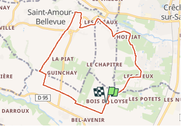
Randonnée A pied de 9,4 km à découvrir à Bourgogne-Franche-Comté, Saône-et-Loire, La Chapelle-de-Guinchay. Cette randonnée est proposée par Bcomb.

Description

Rando facile au départ du bois de Loyse à La Chapelle de Guinchay

Profil altimétrique

Localisation

Pays :
France
Région :
Bourgogne-Franche-Comté
Département/Province :
Saône-et-Loire
Commune :
La Chapelle-de-Guinchay
Localité :
Unknown
Départ:(UTM)
635892 ; 5120531 (31T) N.

Randonnées à proximité

Randonnée Marche Chénas - Chénas - Le Venet - Photo
Marche
jipysn

Marche

Très facile
Chénas, Auvergne-Rhône-Alpes, Rhône, France
3,4 km | 4,5 km-effort
1h 1min
Oui
Randonnée Marche Leynes - LEYNES 71 - Photo
Marche
janussity

Marche

Difficile
Leynes, Bourgogne-Franche-Comté, Saône-et-Loire, France
9,5 km | 12,7 km-effort
2h 38min
Oui
Randonnée Marche Saint-Vérand - St Vérand - Photo
Marche
JPA GRS

Marche

Moyen
(1)
Saint-Vérand, Bourgogne-Franche-Comté, Saône-et-Loire, France
9,8 km | 12,6 km-effort
2h 0min
Oui
Randonnée Marche Fleurie - les vignes de Fleurie - Photo
Marche
reneperrin

Marche

Facile
Fleurie, Auvergne-Rhône-Alpes, Rhône, France
8,1 km | 10,8 km-effort
2h 1min
Oui
Randonnée Marche Chaintré - Chantré  (Saône et Loire) - Photo
Marche
Thomasdanielle

Marche

Moyen
Chaintré, Bourgogne-Franche-Comté, Saône-et-Loire, France
13,8 km | 18,5 km-effort
5h 37min
Oui
Randonnée Course à pied Juliénas - jour 1 CAP Jeanot - Photo
Course à pied
jeannat

Course à pied

Très facile
Juliénas, Auvergne-Rhône-Alpes, Rhône, France
26 km | 38 km-effort
3h 41min
Non
Randonnée Course à pied Fleurie - Marathon Beaujolais - Photo
Course à pied
zazie

Course à pied

Moyen
(1)
Fleurie, Auvergne-Rhône-Alpes, Rhône, France
43 km | 48 km-effort
4h 0min
Non
Randonnée Marche Chénas - Chenas - Le Venet (2) - Photo
Marche
jipysn

Marche

Facile
Chénas, Auvergne-Rhône-Alpes, Rhône, France
5,7 km | 7,6 km-effort
1h 43min
Oui
Randonnée Marche Fleurie - Fleurie - Photo
Marche
janussity

Marche

Difficile
Fleurie, Auvergne-Rhône-Alpes, Rhône, France
11,4 km | 15,7 km-effort
2h 37min
Oui


Fermer
Mes abonnements