![](/images/other/stat-length.png)
20221121 - La Gileppe 6.6 Km
pierreh01
Utilisateur GUIDE
![Longueur](/images/other/stat-length.png)
![Altitude max](https://static1.geolcdn.com/siteimages/upload/files/1508320355ic_sort_altitude_max_24dp.png)
![Dénivelé positif](https://static1.geolcdn.com/siteimages/upload/files/1508320355ic_sort_den_pos_24dp.png)
![Km-Effort](/images/other/stat-length.png)
![Altitude min](https://static1.geolcdn.com/siteimages/upload/files/1508320355ic_sort_altitude_min_24dp.png)
![Dénivelé négatif](https://static1.geolcdn.com/siteimages/upload/files/1508320355ic_sort_den_neg_24dp.png)
![Boucle](https://static1.geolcdn.com/siteimages/upload/files/16400158638029165_repeat_loop_refresh_sync_direction_icon.png)
![Marche](https://static1.geolcdn.com/sitytour/trail-icons/101.png)
1h54
Difficulté : Moyen
![Scannez ce code QR pour ouvrir la randonnée dans l'application SityTrail](https://capi.geolives.com/qq0zvz2zws4bq2lad0pu/sitytour/trails/3462862/qr.png?size=200)
Application GPS de randonnée GRATUITE
À propos
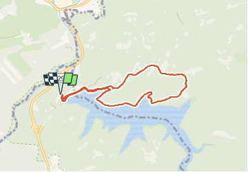
Randonnée Marche de 6,6 km à découvrir à Wallonie, Liège, Jalhay. Cette randonnée est proposée par pierreh01.
Description
Lundi 21 novembre 2022 : Balade hebdomadaire des "BIOS".
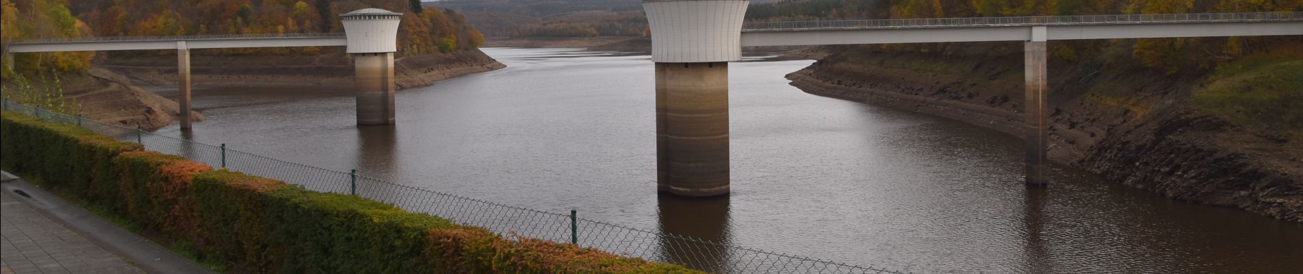
Sous une météo très clémente, avec même un petit rayon de soleil, 24 copains-copines ont suivi André dans une balade au départ de La Gileppe.
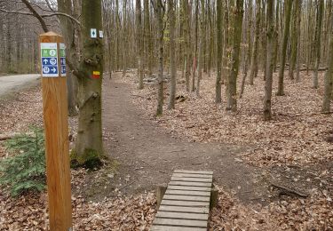
Circuit empruntant de la route et des sentiers forestiers.
ATTENTION !!! Certains sentiers peuvent se trouver sous eau quand le lac est rempli.
Distance mesurée avec Sity Trail semblant plus proche de la réalité.
Localisation
Commentaires
Randonnées à proximité
![Randonnée Marche Limbourg - RB-Lg-28_Limbourg - Photo](https://media.geolcdn.com/t/375/260/ext.jpg?maxdim=2&url=https%3A%2F%2Fservices.sitytrail.com%2FGeolivesWS%2FDownloadMedia.ashx%3FTrailID%3D402093%26Media%3D979895a6-f139-4f7a-8335-2e926c1b89c7.jpg)
![Marche Marche](https://static1.geolcdn.com/sitytour/trail-icons/101.png)
Marche
![](/images/other/stat-length.png)
![](https://static1.geolcdn.com/siteimages/upload/files/16400158638029165_repeat_loop_refresh_sync_direction_icon.png)
![Randonnée Marche Jalhay - La Gileppe - Bois de la Borchêne - Photo](https://media.geolcdn.com/t/375/260/e6c1c191-9060-48ef-8a65-d77cc5b69a34.jpg&format=jpg&maxdim=2)
![Marche Marche](https://static1.geolcdn.com/sitytour/trail-icons/101.png)
Marche
![](/images/other/stat-length.png)
![](https://static1.geolcdn.com/siteimages/upload/files/16400158638029165_repeat_loop_refresh_sync_direction_icon.png)
![Randonnée Marche Baelen - Baelen - Eupen 🎄🎅 - Membach - Photo](https://media.geolcdn.com/t/375/260/d50227a7-424d-470e-90d5-87ebd384de36.jpg&format=jpg&maxdim=2)
![Marche Marche](https://static1.geolcdn.com/sitytour/trail-icons/101.png)
Marche
![](/images/other/stat-length.png)
![](https://static1.geolcdn.com/siteimages/upload/files/16400158638029165_repeat_loop_refresh_sync_direction_icon.png)
![Randonnée Marche Eupen - Autour d'Eupen - Photo](https://media.geolcdn.com/t/375/260/2e56e8e4-4348-489f-86b5-c8ca8af64230.jpg&format=jpg&maxdim=2)
![Marche Marche](https://static1.geolcdn.com/sitytour/trail-icons/101.png)
Marche
![](/images/other/stat-length.png)
![](https://static1.geolcdn.com/siteimages/upload/files/16400158638029165_repeat_loop_refresh_sync_direction_icon.png)
![Randonnée Marche Jalhay - Jalhay-Royompré_-_Balade 47 - Photo](https://media.geolcdn.com/t/375/260/94c262e0-20e7-4ae2-8b45-01b4c31da73b.jpg&format=jpg&maxdim=2)
![Marche Marche](https://static1.geolcdn.com/sitytour/trail-icons/101.png)
Marche
![](/images/other/stat-length.png)
![](https://static1.geolcdn.com/siteimages/upload/files/16400158638029165_repeat_loop_refresh_sync_direction_icon.png)
![Randonnée Marche Eupen - Eupen - Photo](https://media.geolcdn.com/t/375/260/d87483d2-4d3d-461a-a9c9-ec45b2516003.jpg&format=jpg&maxdim=2)
![Marche Marche](https://static1.geolcdn.com/sitytour/trail-icons/101.png)
![Randonnée Marche Baelen - La Montagne du Dragon - Photo](https://media.geolcdn.com/t/375/260/3a1bc634-7bf5-4748-bbb3-513b265a48b5.jpg&format=jpg&maxdim=2)
![Marche Marche](https://static1.geolcdn.com/sitytour/trail-icons/101.png)
Marche
![](/images/other/stat-length.png)
![](https://static1.geolcdn.com/siteimages/upload/files/16400158638029165_repeat_loop_refresh_sync_direction_icon.png)
![Marche Marche](https://static1.geolcdn.com/sitytour/trail-icons/101.png)
Marche
![](/images/other/stat-length.png)
![](https://static1.geolcdn.com/siteimages/upload/files/16400158638029165_repeat_loop_refresh_sync_direction_icon.png)
![Randonnée Marche Limbourg - RL-GG-11_Dolhain-Gileppe_Pepinster - Photo](https://media.geolcdn.com/t/375/260/9cf2c240-5913-4088-b4f6-6c0e1fae0233.jpg&format=jpg&maxdim=2)
![Marche Marche](https://static1.geolcdn.com/sitytour/trail-icons/101.png)
Marche
![](/images/other/stat-length.png)
![](https://static1.geolcdn.com/siteimages/upload/files/16400158638029165_repeat_loop_refresh_sync_direction_icon.png)