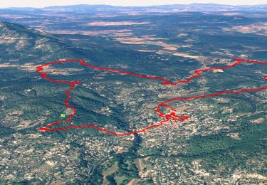
![](/images/other/stat-length.png)
![Randonnée Marche Cotignac - Gros Bessillon, Cotignac - Photo](https://media.geolcdn.com/t/1900/400/a81bddb8-87f5-460d-8429-4f14fe2dbd16.jpg&format=pjpeg&maxdim=2)
Gros Bessillon, Cotignac
GrouGary
Utilisateur
![Longueur](/images/other/stat-length.png)
![Altitude max](https://static1.geolcdn.com/siteimages/upload/files/1508320355ic_sort_altitude_max_24dp.png)
![Dénivelé positif](https://static1.geolcdn.com/siteimages/upload/files/1508320355ic_sort_den_pos_24dp.png)
![Km-Effort](/images/other/stat-length.png)
![Altitude min](https://static1.geolcdn.com/siteimages/upload/files/1508320355ic_sort_altitude_min_24dp.png)
![Dénivelé négatif](https://static1.geolcdn.com/siteimages/upload/files/1508320355ic_sort_den_neg_24dp.png)
![Boucle](https://static1.geolcdn.com/siteimages/upload/files/16400158638029165_repeat_loop_refresh_sync_direction_icon.png)
![Marche](https://static1.geolcdn.com/sitytour/trail-icons/101.png)
4h00
Difficulté : Facile
![Scannez ce code QR pour ouvrir la randonnée dans l'application SityTrail](https://capi.geolives.com/qq0zvz2zws4bq2lad0pu/sitytour/trails/3461432/qr.png?size=200)
Application GPS de randonnée GRATUITE
À propos
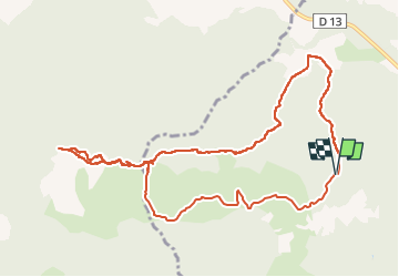
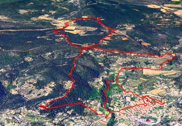
Randonnée Marche de 11,9 km à découvrir à Provence-Alpes-Côte d'Azur, Var, Cotignac. Cette randonnée est proposée par GrouGary.
Description
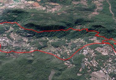
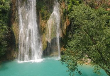
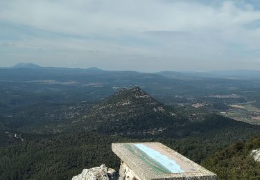
Boucle autour du Gros Bessillon, adapté à randonnée automnale et hivernale. Départ Parking à côté du Monastère st Joseph à 9h (Messe et chants grégoriens le matin). Descendre la sente sous le Monastère pour rejoindre la très longue piste en face Sud du "Gros Bessillon". Ne pas la poursuivre car trop longue, même si la vue est large et belle. Repérer à droite (2ème vallon) deux cairns qui signalent la sente raide à gravir mais non difficile, et rejoindre la route goudronnée montante vers la Tour de Gué et Antennes : Superbe relief karstique et ruiniforme. Eviter le plus possible la route goudronnée pour suivre la crête. Pic Nic à la Tour de Gué avec une vue 360° Ste Baume,Ste Victoire,... Les Ecrins enneigés, le Mourre de Chanier, ...
Retour en alternance crête/route goudronnée pour revenir à la sente de montée. Repérer dans le superbe relief ruiniforme le petit sentier à droite qui mène à la roche trouée.
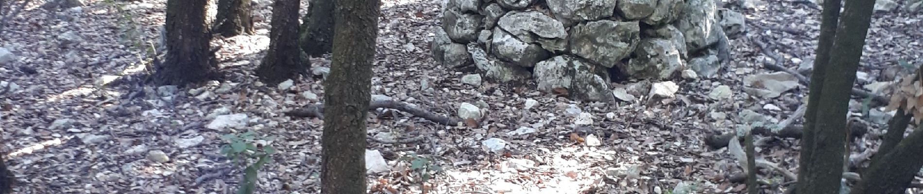
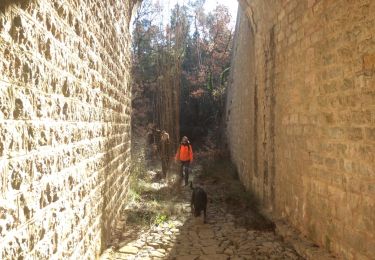
Revenir sur la route et la quitter pour entrer, par sente, dans les bois de chênes qui cachent les anciens cairns (8 sont bien visibles entre les arbres) construits tous les 50 m et désignant l'ancien accès au gros Bessillon.
Conseil : ne pas suivre la route pour rejoindre le Monastère mais poursuivre à travers les bois dans des sentes très nettes... mais avec l'aide d'un bon GPS.
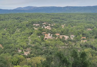
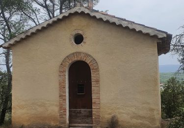
Visite des tours sarrasines et Cotignac, classé récemment "Plus Beau Village de France"
Localisation
Commentaires
Randonnées à proximité
![Randonnée Marche Cotignac - Cotignac - Les chapelles - Habitat Troglodyte - (V2 courte) - Photo](https://media.geolcdn.com/t/375/260/3df5ec25-d552-4f62-91dd-9a69845e3551.jpg&format=jpg&maxdim=2)
![Marche Marche](https://static1.geolcdn.com/sitytour/trail-icons/101.png)
Marche
![](/images/other/stat-length.png)
![](https://static1.geolcdn.com/siteimages/upload/files/16400158638029165_repeat_loop_refresh_sync_direction_icon.png)
![Randonnée Marche Sillans-la-Cascade - Traversée Sillans - Cascade - Chemin du train des pignes - Ruines chateau Salernes - Piscine Salerne - Bord de rivière - Chapelle St Laurent - Photo](https://media.geolcdn.com/t/375/260/4b45470f-3ffd-48ed-a237-4271c6a3710f.jpg&format=jpg&maxdim=2)
![Marche Marche](https://static1.geolcdn.com/sitytour/trail-icons/101.png)
Marche
![](/images/other/stat-length.png)
![](https://static1.geolcdn.com/siteimages/upload/files/16400158638029165_repeat_loop_refresh_sync_direction_icon.png)
![Randonnée Marche Cotignac - Cotignac - Les chapelles - Habitat Troglodyte - (V1 longue) - Photo](https://media.geolcdn.com/t/375/260/f720fb36-9a63-45e5-a4fe-2f41a31767be.jpg&format=jpg&maxdim=2)
![Marche Marche](https://static1.geolcdn.com/sitytour/trail-icons/101.png)
Marche
![](/images/other/stat-length.png)
![](https://static1.geolcdn.com/siteimages/upload/files/16400158638029165_repeat_loop_refresh_sync_direction_icon.png)
![Randonnée Marche Sillans-la-Cascade - Caseneuve - Photo](https://media.geolcdn.com/t/375/260/ext.jpg?maxdim=2&url=https%3A%2F%2Fservices.sitytrail.com%2FGeolivesWS%2FDownloadMedia.ashx%3FTrailID%3D699653%26Media%3D20170105120554.jpg)
![Marche Marche](https://static1.geolcdn.com/sitytour/trail-icons/101.png)
Marche
![](/images/other/stat-length.png)
![](https://static1.geolcdn.com/siteimages/upload/files/16400158638029165_repeat_loop_refresh_sync_direction_icon.png)
![Randonnée Marche Sillans-la-Cascade - 2024-03-05 La Bresque - Photo](https://media.geolcdn.com/t/375/260/c9038386-6b03-4f45-be3c-f8ce6bafb362.jpg&format=jpg&maxdim=2)
![Marche Marche](https://static1.geolcdn.com/sitytour/trail-icons/101.png)
Marche
![](/images/other/stat-length.png)
![](https://static1.geolcdn.com/siteimages/upload/files/16400158638029165_repeat_loop_refresh_sync_direction_icon.png)
![Randonnée Marche Sillans-la-Cascade - 2023-10-22 La Bresque mystérieuse - Photo](https://media.geolcdn.com/t/375/260/ee8614e1-7a27-45d8-a32a-4b544fdb8d39.jpg&format=jpg&maxdim=2)
![Marche Marche](https://static1.geolcdn.com/sitytour/trail-icons/101.png)
Marche
![](/images/other/stat-length.png)
![](https://static1.geolcdn.com/siteimages/upload/files/16400158638029165_repeat_loop_refresh_sync_direction_icon.png)
![Randonnée Marche Sillans-la-Cascade - 23-10-2022 Sillans La Cascade - Croix de Solliès - Salernes - Photo](https://media.geolcdn.com/t/375/260/e872b945-c289-4b77-8147-4bedd1cc41eb.jpg&format=jpg&maxdim=2)
![Marche Marche](https://static1.geolcdn.com/sitytour/trail-icons/101.png)
Marche
![](/images/other/stat-length.png)
![](https://static1.geolcdn.com/siteimages/upload/files/16400158638029165_repeat_loop_refresh_sync_direction_icon.png)
![Randonnée Marche Sillans-la-Cascade - seillan 400m 14kms - Photo](https://media.geolcdn.com/t/375/260/da3715af-554a-4a18-b362-45ad0923842d.jpg&format=jpg&maxdim=2)
![Marche Marche](https://static1.geolcdn.com/sitytour/trail-icons/101.png)
Marche
![](/images/other/stat-length.png)
![](https://static1.geolcdn.com/siteimages/upload/files/16400158638029165_repeat_loop_refresh_sync_direction_icon.png)
![Randonnée Marche Cotignac - Tour du gros Bessillon - Photo](https://media.geolcdn.com/t/375/260/779808d6-cf2d-4575-a137-1a82d1025a08.jpg&format=jpg&maxdim=2)
![Marche Marche](https://static1.geolcdn.com/sitytour/trail-icons/101.png)
Marche
![](/images/other/stat-length.png)
![](https://static1.geolcdn.com/siteimages/upload/files/16400158638029165_repeat_loop_refresh_sync_direction_icon.png)