![](/images/other/stat-length.png)
Pin de Luquet, Les Laouvas, Crot du Pont
ericberlin
Utilisateur
![Longueur](/images/other/stat-length.png)
Longueur
6,2 km
![Altitude max](https://static1.geolcdn.com/siteimages/upload/files/1508320355ic_sort_altitude_max_24dp.png)
Altitude max
308 m
![Dénivelé positif](https://static1.geolcdn.com/siteimages/upload/files/1508320355ic_sort_den_pos_24dp.png)
Dénivelé positif
109 m
![Km-Effort](/images/other/stat-length.png)
Km-Effort
7,7 km
![Altitude min](https://static1.geolcdn.com/siteimages/upload/files/1508320355ic_sort_altitude_min_24dp.png)
Altitude min
249 m
![Dénivelé négatif](https://static1.geolcdn.com/siteimages/upload/files/1508320355ic_sort_den_neg_24dp.png)
Dénivelé négatif
111 m
![Boucle](https://static1.geolcdn.com/siteimages/upload/files/16400158638029165_repeat_loop_refresh_sync_direction_icon.png)
Boucle
Oui
Date de création :
2022-11-12 15:04:38.366
Dernière modification :
2022-11-12 16:23:45.299
![Marche](https://static1.geolcdn.com/sitytour/trail-icons/101.png)
1h44
Difficulté : Moyen
![Course à pied](https://static1.geolcdn.com/sitytour/trail-icons/103.png)
45m
Difficulté : Très facile
![Scannez ce code QR pour ouvrir la randonnée dans l'application SityTrail](https://capi.geolives.com/qq0zvz2zws4bq2lad0pu/sitytour/trails/3454655/qr.png?size=200)
Application GPS de randonnée GRATUITE
À propos
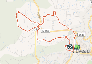
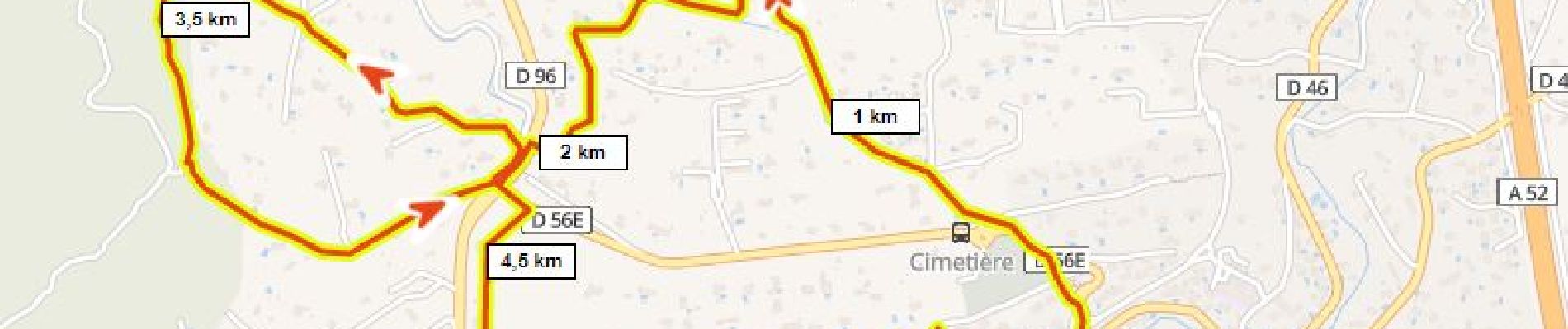
Randonnée Marche de 6,2 km à découvrir à Provence-Alpes-Côte d'Azur, Bouches-du-Rhône, Fuveau. Cette randonnée est proposée par ericberlin.
Description
Boucle depuis la gare routière:
Ancien Chemin d'Aix, canal, Les Laouvas, ancien canal, retour par le ch du Crot du Pont, le canal, le parking G. Marchi.
Itinéraire relativement plat et tranquille
Localisation
Pays :
France
Région :
Provence-Alpes-Côte d'Azur
Département/Province :
Bouches-du-Rhône
Commune :
Fuveau
Localité :
Unknown
Départ:(Dec)
Départ:(UTM)
706986 ; 4814351 (31T) N.
Commentaires
Randonnées à proximité
![V.T.T. V.T.T.](https://static1.geolcdn.com/sitytour/trail-icons/202.png)
Le Regagnas par Belcodène retour par Kirbon et Les Michels D+715m
V.T.T.
Très difficile
(1)
Fuveau,
Provence-Alpes-Côte d'Azur,
Bouches-du-Rhône,
France
![](/images/other/stat-length.png)
33 km | 43 km-effort
2h 59min
![](https://static1.geolcdn.com/siteimages/upload/files/16400158638029165_repeat_loop_refresh_sync_direction_icon.png)
Oui
![Marche Marche](https://static1.geolcdn.com/sitytour/trail-icons/101.png)
Canal par le chemin de fer
Marche
Très difficile
(1)
Fuveau,
Provence-Alpes-Côte d'Azur,
Bouches-du-Rhône,
France
![](/images/other/stat-length.png)
16,8 km | 21 km-effort
4h 40min
![](https://static1.geolcdn.com/siteimages/upload/files/16400158638029165_repeat_loop_refresh_sync_direction_icon.png)
Oui
![V.T.T. V.T.T.](https://static1.geolcdn.com/sitytour/trail-icons/202.png)
La corniche des 2 barrages de Ste Victoire
V.T.T.
Très difficile
(1)
Fuveau,
Provence-Alpes-Côte d'Azur,
Bouches-du-Rhône,
France
![](/images/other/stat-length.png)
35 km | 45 km-effort
3h 7min
![](https://static1.geolcdn.com/siteimages/upload/files/16400158638029165_repeat_loop_refresh_sync_direction_icon.png)
Oui
![Vélo de route Vélo de route](https://static1.geolcdn.com/sitytour/trail-icons/201.png)
Vallée de l'Arc et retour par Pourrières Puyloubier Chateauneuf
Vélo de route
Très difficile
(1)
Fuveau,
Provence-Alpes-Côte d'Azur,
Bouches-du-Rhône,
France
![](/images/other/stat-length.png)
42 km | 47 km-effort
2h 52min
![](https://static1.geolcdn.com/siteimages/upload/files/16400158638029165_repeat_loop_refresh_sync_direction_icon.png)
Oui
![V.T.T. V.T.T.](https://static1.geolcdn.com/sitytour/trail-icons/202.png)
4 Termes, Chateau-bas, Siminane, Pilon, Col St-Anne, Mimet, Gréasque
V.T.T.
Très difficile
(1)
Fuveau,
Provence-Alpes-Côte d'Azur,
Bouches-du-Rhône,
France
![](/images/other/stat-length.png)
36 km | 47 km-effort
3h 13min
![](https://static1.geolcdn.com/siteimages/upload/files/16400158638029165_repeat_loop_refresh_sync_direction_icon.png)
Oui
![Marche Marche](https://static1.geolcdn.com/sitytour/trail-icons/101.png)
La centrale photovoltaique par le chemin de fer
Marche
Difficile
(1)
Fuveau,
Provence-Alpes-Côte d'Azur,
Bouches-du-Rhône,
France
![](/images/other/stat-length.png)
10,1 km | 12,6 km-effort
2h 52min
![](https://static1.geolcdn.com/siteimages/upload/files/16400158638029165_repeat_loop_refresh_sync_direction_icon.png)
Oui
![Vélo de route Vélo de route](https://static1.geolcdn.com/sitytour/trail-icons/201.png)
Tour Ste Victoire D+1200m
Vélo de route
Très difficile
(1)
Fuveau,
Provence-Alpes-Côte d'Azur,
Bouches-du-Rhône,
France
![](/images/other/stat-length.png)
72 km | 88 km-effort
5h 21min
![](https://static1.geolcdn.com/siteimages/upload/files/16400158638029165_repeat_loop_refresh_sync_direction_icon.png)
Oui
![V.T.T. V.T.T.](https://static1.geolcdn.com/sitytour/trail-icons/202.png)
Fuveau, Regagnas, La Couelle, Kirbon, Les Michels, Fuveau D+790m
V.T.T.
Très difficile
(1)
Fuveau,
Provence-Alpes-Côte d'Azur,
Bouches-du-Rhône,
France
![](/images/other/stat-length.png)
38 km | 49 km-effort
3h 24min
![](https://static1.geolcdn.com/siteimages/upload/files/16400158638029165_repeat_loop_refresh_sync_direction_icon.png)
Oui
![Vélo de route Vélo de route](https://static1.geolcdn.com/sitytour/trail-icons/201.png)
Maison de la Ste Victoire D+590m
Vélo de route
Très difficile
(1)
Fuveau,
Provence-Alpes-Côte d'Azur,
Bouches-du-Rhône,
France
![](/images/other/stat-length.png)
36 km | 44 km-effort
2h 40min
![](https://static1.geolcdn.com/siteimages/upload/files/16400158638029165_repeat_loop_refresh_sync_direction_icon.png)
Oui