Randonnée Marche Champlecy - 12/11/22 - Photo
 Sasuke69us
Sasuke69us

Utilisateur

© OpenStreetMap contributors
Longueur
Longueur
2,9 km
Altitude max
Altitude max
333 m
Dénivelé positif
Dénivelé positif
26 m
Km-Effort
Km-Effort  
3,2 km
Altitude min
Altitude min
316 m
Dénivelé négatif
Dénivelé négatif
32 m
Boucle
Boucle
Non
Date de création :
2022-11-12 08:39:13.0
Dernière modification :
2022-11-12 11:28:45.175

(0 Avis)

Marche
Marche
2h49
Difficulté : Facile

Scannez ce code QR pour ouvrir la randonnée dans l'application SityTrail

Application GPS de randonnée GRATUITE

Logo SityTrail SityTrail

IGN / Instituts géographiques

Télécharger SityTrail sur l'App Store Télécharger SityTrail sur Google Play

Logo SityTrail SityTrail World

Le monde est à vous

Télécharger SityTrail sur l'App Store Télécharger SityTrail sur Google Play Télécharger SityTrail sur Huawei AppGallery

À propos

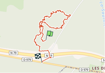
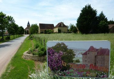
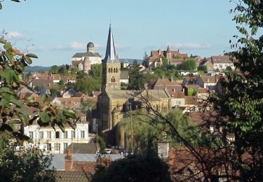
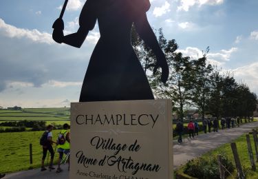
Randonnée Marche de 2,9 km à découvrir à Bourgogne-Franche-Comté, Saône-et-Loire, Champlecy. Cette randonnée est proposée par Sasuke69us.

Description

12/11/22

Profil altimétrique

Localisation

Pays :
France
Région :
Bourgogne-Franche-Comté
Département/Province :
Saône-et-Loire
Commune :
Champlecy
Localité :
Unknown
Départ:(Dec)
Départ:(UTM)
593905 ; 5144152 (31T) N.

Randonnées à proximité

Randonnée V.T.T. Champlecy - VTT autour de Champlecy - Photo
V.T.T.
tracegps

V.T.T.

Facile
Champlecy, Bourgogne-Franche-Comté, Saône-et-Loire, France
26 km | 31 km-effort
2h 19min
Oui
Randonnée V.T.T. Charolles - 5ème Marche du Boeuf 2012 VTT  25km - Charolles - Photo
V.T.T.
tracegps

V.T.T.

Moyen
Charolles, Bourgogne-Franche-Comté, Saône-et-Loire, France
28 km | 34 km-effort
2h 30min
Oui
Randonnée Marche Champlecy - champlecy - Photo
Marche

Marche

Difficile
Champlecy, Bourgogne-Franche-Comté, Saône-et-Loire, France
10,5 km | 12,6 km-effort
2h 35min
Oui
Randonnée Marche Champlecy - champlecy - Photo
Marche
Malice0093

Marche

Difficile
Champlecy, Bourgogne-Franche-Comté, Saône-et-Loire, France
11,2 km | 13,3 km-effort
3h 1min
Oui
Randonnée Autre activité Charolles - rondje charolles - Photo
Autre activité
fritsaubin

Autre activité

Facile
Charolles, Bourgogne-Franche-Comté, Saône-et-Loire, France
6,7 km | 8,1 km-effort
1h 38min
Oui
Randonnée Marche Hautefond - Lugny les charolles voie ferrée  - Photo
Marche
denis alloin

Marche

Hautefond, Bourgogne-Franche-Comté, Saône-et-Loire, France
1,8 km | 2 km-effort
1h 6min
Oui
Randonnée Marche Charolles - charolles - Photo
Marche
darancette

Marche

Facile
Charolles, Bourgogne-Franche-Comté, Saône-et-Loire, France
3,9 km | 4,7 km-effort
1h 0min
Oui
Randonnée Marche Changy - changy tourny - Photo
Marche

Marche

Très difficile
(1)
Changy, Bourgogne-Franche-Comté, Saône-et-Loire, France
19,1 km | 24 km-effort
5h 33min
Oui
Randonnée Marche Champlecy - Champlecy - Photo
Marche
Bonnefois Bernard

Marche

Champlecy, Bourgogne-Franche-Comté, Saône-et-Loire, France
5 km | 6 km-effort
1h 46min
Oui


Fermer
Mes abonnements