![](/images/other/stat-length.png)
Traversée d'Andorre D+3000m
ericberlin
Utilisateur
![Longueur](/images/other/stat-length.png)
Longueur
137 km
![Altitude max](https://static1.geolcdn.com/siteimages/upload/files/1508320355ic_sort_altitude_max_24dp.png)
Altitude max
2413 m
![Dénivelé positif](https://static1.geolcdn.com/siteimages/upload/files/1508320355ic_sort_den_pos_24dp.png)
Dénivelé positif
2965 m
![Km-Effort](/images/other/stat-length.png)
Km-Effort
177 km
![Altitude min](https://static1.geolcdn.com/siteimages/upload/files/1508320355ic_sort_altitude_min_24dp.png)
Altitude min
685 m
![Dénivelé négatif](https://static1.geolcdn.com/siteimages/upload/files/1508320355ic_sort_den_neg_24dp.png)
Dénivelé négatif
2966 m
![Boucle](https://static1.geolcdn.com/siteimages/upload/files/16400158638029165_repeat_loop_refresh_sync_direction_icon.png)
Boucle
Oui
Date de création :
2022-11-08 10:49:00.122
Dernière modification :
2023-06-05 14:59:41.604
![Vélo de route](https://static1.geolcdn.com/sitytour/trail-icons/201.png)
10h42
Difficulté : Très difficile
![Scannez ce code QR pour ouvrir la randonnée dans l'application SityTrail](https://capi.geolives.com/qq0zvz2zws4bq2lad0pu/sitytour/trails/3449773/qr.png?size=200)
Application GPS de randonnée GRATUITE
À propos
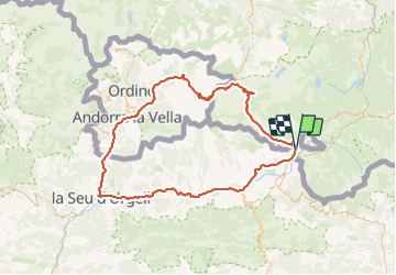
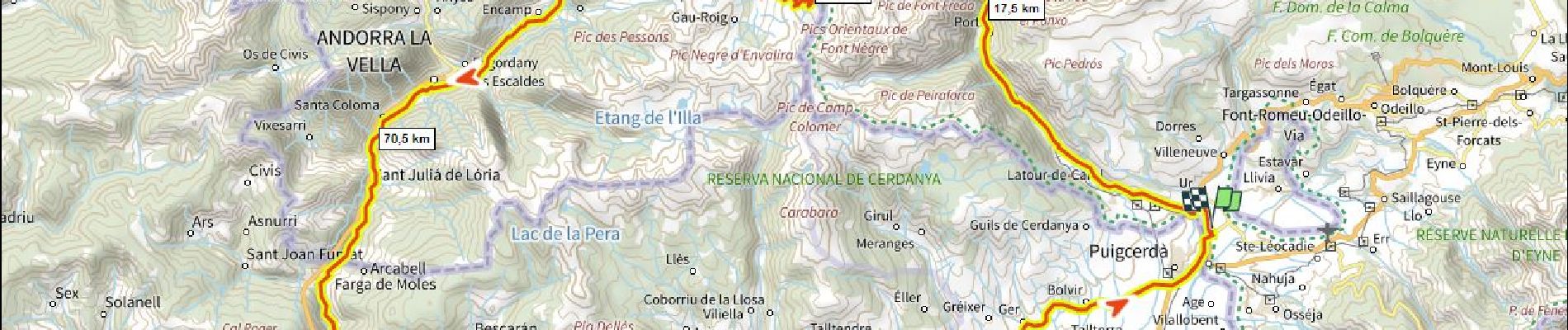
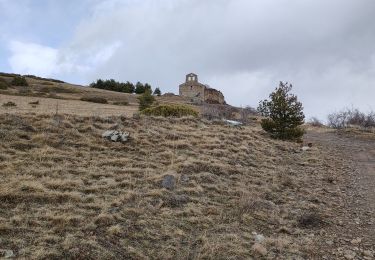
Randonnée Vélo de route de 137 km à découvrir à Occitanie, Pyrénées-Orientales, Ur. Cette randonnée est proposée par ericberlin.
Description
Boucle tri-nationale faite plus jeune par le Port d' Envalira 2408m (le plus haut col routier des Pyrennées) et la Seu d'Orgell.
Partis très tôt le matin pour éviter la circulation intense.
Localisation
Pays :
France
Région :
Occitanie
Département/Province :
Pyrénées-Orientales
Commune :
Ur
Localité :
Unknown
Départ:(Dec)
Départ:(UTM)
413327 ; 4699987 (31T) N.
Commentaires
Randonnées à proximité
![Randonnée Marche Ur - de Ur vers La Chapelle de Belloc - Photo](https://media.geolcdn.com/t/375/260/ext.jpg?maxdim=2&url=https%3A%2F%2Fservices.sitytrail.com%2FGeolivesWS%2FDownloadMedia.ashx%3FTrailID%3D661447%26Media%3D20161117163202.jpg)
![Marche Marche](https://static1.geolcdn.com/sitytour/trail-icons/101.png)
de Ur vers La Chapelle de Belloc
Marche
Facile
(1)
Ur,
Occitanie,
Pyrénées-Orientales,
France
![](/images/other/stat-length.png)
20 km | 28 km-effort
7h 14min
![](https://static1.geolcdn.com/siteimages/upload/files/16400158638029165_repeat_loop_refresh_sync_direction_icon.png)
Oui
![Randonnée Marche Nahuja - boucle de Nahuja - Photo](https://media.geolcdn.com/t/375/260/ext.jpg?maxdim=2&url=https%3A%2F%2Fservices.sitytrail.com%2FGeolivesWS%2FDownloadMedia.ashx%3FTrailID%3D558835%26Media%3D20160425135530.jpg)
![Marche Marche](https://static1.geolcdn.com/sitytour/trail-icons/101.png)
boucle de Nahuja
Marche
Moyen
(1)
Nahuja,
Occitanie,
Pyrénées-Orientales,
France
![](/images/other/stat-length.png)
11,8 km | 18,2 km-effort
2h 44min
![](https://static1.geolcdn.com/siteimages/upload/files/16400158638029165_repeat_loop_refresh_sync_direction_icon.png)
Oui
![Randonnée Marche Estavar - 20220328 Estavar-Tartassonne(?) - Photo](https://media.geolcdn.com/t/375/260/d3a84297-78f4-4823-a8d6-7ab122d863c3.jpg&format=jpg&maxdim=2)
![Marche Marche](https://static1.geolcdn.com/sitytour/trail-icons/101.png)
20220328 Estavar-Tartassonne(?)
Marche
Moyen
Estavar,
Occitanie,
Pyrénées-Orientales,
France
![](/images/other/stat-length.png)
14,8 km | 22 km-effort
3h 16min
![](https://static1.geolcdn.com/siteimages/upload/files/16400158638029165_repeat_loop_refresh_sync_direction_icon.png)
Oui
![Raquettes à neige Raquettes à neige](https://static1.geolcdn.com/sitytour/trail-icons/504.png)
2021-02-10 Sortie CAF - Port de Maurà depuis Dorres
Raquettes à neige
Difficile
Dorres,
Occitanie,
Pyrénées-Orientales,
France
![](/images/other/stat-length.png)
17,9 km | 31 km-effort
9h 0min
![](https://static1.geolcdn.com/siteimages/upload/files/16400158638029165_repeat_loop_refresh_sync_direction_icon.png)
Oui
![Marche Marche](https://static1.geolcdn.com/sitytour/trail-icons/101.png)
2021-02-09 Sortie CAF - Dorres - Chapelle de Belloc - Dolmen de Brangoli
Marche
Facile
Dorres,
Occitanie,
Pyrénées-Orientales,
France
![](/images/other/stat-length.png)
13 km | 19,3 km-effort
5h 0min
![](https://static1.geolcdn.com/siteimages/upload/files/16400158638029165_repeat_loop_refresh_sync_direction_icon.png)
Oui
![Randonnée Marche Dorres - d'ores 2 - Photo](https://media.geolcdn.com/t/375/260/8d443e8b-e448-46c9-8d35-e5b2b8654ee9.jpg&format=jpg&maxdim=2)
![Marche Marche](https://static1.geolcdn.com/sitytour/trail-icons/101.png)
d'ores 2
Marche
Moyen
Dorres,
Occitanie,
Pyrénées-Orientales,
France
![](/images/other/stat-length.png)
7,7 km | 11,1 km-effort
2h 46min
![](https://static1.geolcdn.com/siteimages/upload/files/16400158638029165_repeat_loop_refresh_sync_direction_icon.png)
Oui
![Randonnée Marche Enveitg - Bena - Photo](https://media.geolcdn.com/t/375/260/165e97a2-1242-4fc7-ad8f-1f50eaed5ba5.jpg&format=jpg&maxdim=2)
![Marche Marche](https://static1.geolcdn.com/sitytour/trail-icons/101.png)
Bena
Marche
Moyen
Enveitg,
Occitanie,
Pyrénées-Orientales,
France
![](/images/other/stat-length.png)
11,9 km | 21 km-effort
3h 32min
![](https://static1.geolcdn.com/siteimages/upload/files/16400158638029165_repeat_loop_refresh_sync_direction_icon.png)
Non
![Randonnée Marche Dorres - Le chemin du Belloc - Photo](https://media.geolcdn.com/t/375/260/baea90ac-684a-4947-b800-0eea24315e65.jpg&format=jpg&maxdim=2)
![Marche Marche](https://static1.geolcdn.com/sitytour/trail-icons/101.png)
Le chemin du Belloc
Marche
Dorres,
Occitanie,
Pyrénées-Orientales,
France
![](/images/other/stat-length.png)
5,6 km | 8,9 km-effort
1h 44min
![](https://static1.geolcdn.com/siteimages/upload/files/16400158638029165_repeat_loop_refresh_sync_direction_icon.png)
Non
![Randonnée Marche Dorres - Dorres vers les estanyets - Photo](https://media.geolcdn.com/t/375/260/ext.jpg?maxdim=2&url=https%3A%2F%2Fservices.sitytrail.com%2FGeolivesWS%2FDownloadMedia.ashx%3FTrailID%3D1011850%26Media%3Dfix__20180727093345.jpg)
![Marche Marche](https://static1.geolcdn.com/sitytour/trail-icons/101.png)
Dorres vers les estanyets
Marche
Difficile
Dorres,
Occitanie,
Pyrénées-Orientales,
France
![](/images/other/stat-length.png)
18 km | 30 km-effort
8h 49min
![](https://static1.geolcdn.com/siteimages/upload/files/16400158638029165_repeat_loop_refresh_sync_direction_icon.png)
Oui