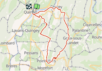
![](/images/other/stat-length.png)
![Randonnée Marche Quingey - quingey1 - Photo](https://media.geolcdn.com/t/1900/400/ext.pjpeg?maxdim=2&url=https%3A%2F%2Fstatic1.geolcdn.com%2Fsiteimages%2Fupload%2Ffiles%2F1553511878bg_sport_marche.png)
quingey1
eltonnermou
Utilisateur
![Longueur](/images/other/stat-length.png)
![Altitude max](https://static1.geolcdn.com/siteimages/upload/files/1508320355ic_sort_altitude_max_24dp.png)
![Dénivelé positif](https://static1.geolcdn.com/siteimages/upload/files/1508320355ic_sort_den_pos_24dp.png)
![Km-Effort](/images/other/stat-length.png)
![Altitude min](https://static1.geolcdn.com/siteimages/upload/files/1508320355ic_sort_altitude_min_24dp.png)
![Dénivelé négatif](https://static1.geolcdn.com/siteimages/upload/files/1508320355ic_sort_den_neg_24dp.png)
![Boucle](https://static1.geolcdn.com/siteimages/upload/files/16400158638029165_repeat_loop_refresh_sync_direction_icon.png)
![Marche](https://static1.geolcdn.com/sitytour/trail-icons/101.png)
6h13
Difficulté : Moyen
![Scannez ce code QR pour ouvrir la randonnée dans l'application SityTrail](https://capi.geolives.com/qq0zvz2zws4bq2lad0pu/sitytour/trails/3449086/qr.png?size=200)
Application GPS de randonnée GRATUITE
À propos
Randonnée Marche de 17,9 km à découvrir à Bourgogne-Franche-Comté, Doubs, Quingey. Cette randonnée est proposée par eltonnermou.
Description
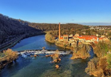
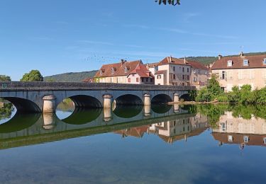
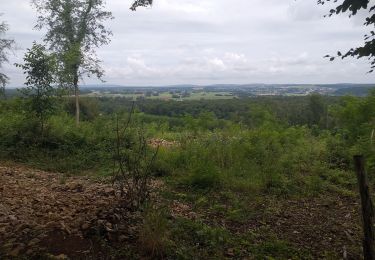
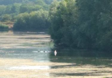
Cette belle randonnée pédestre vous entrainera à travers différents paysages . Vous longerez la Loue , qui en cas de crue rend cette randonnée impraticable.
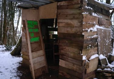
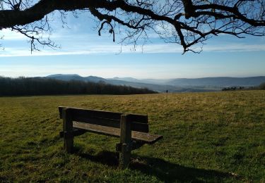
Cette randonnée vous offrira quelques points de vues et 2 sites propices au pique-nique : un avec une table et 2 bancs au premier point de vue (8,5km), l'autre 500m plus loin dans un chalet pour randonneurs.
A environ 10 km et une fois après avoir quitté la route D15, sur ce sentier que vous avez pris à main droite, au premier croisement rencontré partez à gauche en direction de Pointvillers. A la rencontre de la route D15 à l'entrée du village prenez la D15 sur quelques mètres pour prendre aussitôt à droite ce large sentier. Vous rejoindrez la trace un peu plus loin (cela vous évitera de prendre à travers bois et champs.
Avec un peu de chance, vous surprendrez des chevreuils ou chamois. Vous pourrez apprécier la diversité de la flore et profiter d'un parcours ombragé et très agréable.
Localisation
Commentaires
Randonnées à proximité
![Randonnée Marche Quingey - quingeoise - Photo](https://media.geolcdn.com/t/375/260/ext.jpg?maxdim=2&url=https%3A%2F%2Fstatic1.geolcdn.com%2Fsiteimages%2Fupload%2Ffiles%2F1553511878bg_sport_marche.png)
![Marche Marche](https://static1.geolcdn.com/sitytour/trail-icons/101.png)
Marche
![](/images/other/stat-length.png)
![](https://static1.geolcdn.com/siteimages/upload/files/16400158638029165_repeat_loop_refresh_sync_direction_icon.png)
![Randonnée A pied Osselle-Routelle - Sentier sur les Roches - Photo](https://media.geolcdn.com/t/375/260/e9dbaf43-a2c7-4d27-a8c7-398f960f90f6.jpeg&format=jpg&maxdim=2)
![A pied A pied](https://static1.geolcdn.com/sitytour/trail-icons/100.png)
A pied
![](/images/other/stat-length.png)
![](https://static1.geolcdn.com/siteimages/upload/files/16400158638029165_repeat_loop_refresh_sync_direction_icon.png)
![Randonnée Marche Lombard - Lombard - Photo](https://media.geolcdn.com/t/375/260/b115cf83-3571-419e-9898-67fe86dca798.jpg&format=jpg&maxdim=2)
![Marche Marche](https://static1.geolcdn.com/sitytour/trail-icons/101.png)
Marche
![](/images/other/stat-length.png)
![](https://static1.geolcdn.com/siteimages/upload/files/16400158638029165_repeat_loop_refresh_sync_direction_icon.png)
![Randonnée Marche Chouzelot - petit tour dominical de Quinjey - Photo](https://media.geolcdn.com/t/375/260/cc6bebd6-5acf-4559-878f-8874ef8b0e28.jpg&format=jpg&maxdim=2)
![Marche Marche](https://static1.geolcdn.com/sitytour/trail-icons/101.png)
Marche
![](/images/other/stat-length.png)
![](https://static1.geolcdn.com/siteimages/upload/files/16400158638029165_repeat_loop_refresh_sync_direction_icon.png)
![Randonnée Marche Villars-Saint-Georges - villars - Photo](https://media.geolcdn.com/t/375/260/6f0a5bb8-9815-4e4c-82ee-8310f8462339.jpg&format=jpg&maxdim=2)
![Marche Marche](https://static1.geolcdn.com/sitytour/trail-icons/101.png)
Marche
![](/images/other/stat-length.png)
![](https://static1.geolcdn.com/siteimages/upload/files/16400158638029165_repeat_loop_refresh_sync_direction_icon.png)
![Randonnée Marche Cessey - Cessey 2021-01-26 rando CAF - Photo](https://media.geolcdn.com/t/375/260/672450e4-6204-40da-8680-b68dabe30a24.jpg&format=jpg&maxdim=2)
![Marche Marche](https://static1.geolcdn.com/sitytour/trail-icons/101.png)
Marche
![](/images/other/stat-length.png)
![](https://static1.geolcdn.com/siteimages/upload/files/16400158638029165_repeat_loop_refresh_sync_direction_icon.png)
![Randonnée Marche Abbans-Dessous - le château du marquis, abbans dessous - Photo](https://media.geolcdn.com/t/375/260/ext.jpg?maxdim=2&url=https%3A%2F%2Fservices.sitytrail.com%2FGeolivesWS%2FDownloadMedia.ashx%3FTrailID%3D1133664%26Media%3Dfix__20190411092805.jpg)
![Marche Marche](https://static1.geolcdn.com/sitytour/trail-icons/101.png)
Marche
![](/images/other/stat-length.png)
![](https://static1.geolcdn.com/siteimages/upload/files/16400158638029165_repeat_loop_refresh_sync_direction_icon.png)
![Randonnée Marche Quingey - Quingey Montfort 21 janv 2020 CAF - Photo](https://media.geolcdn.com/t/375/260/d3d00327-7bf6-40ba-b0f3-b4de8d12cc88.jpg&format=jpg&maxdim=2)
![Marche Marche](https://static1.geolcdn.com/sitytour/trail-icons/101.png)
Marche
![](/images/other/stat-length.png)
![](https://static1.geolcdn.com/siteimages/upload/files/16400158638029165_repeat_loop_refresh_sync_direction_icon.png)
![Randonnée Marche Osselle-Routelle - Osselle sablière - Photo](https://media.geolcdn.com/t/375/260/c5594248-53c6-4509-838f-ae7c4be0ac69.jpg&format=jpg&maxdim=2)
![Marche Marche](https://static1.geolcdn.com/sitytour/trail-icons/101.png)
Marche
![](/images/other/stat-length.png)
![](https://static1.geolcdn.com/siteimages/upload/files/16400158638029165_repeat_loop_refresh_sync_direction_icon.png)