![](/images/other/stat-length.png)
![Randonnée Marche Rheinbreitbach - Rheinbreitbach - Photo](https://media.geolcdn.com/t/1900/400/ext.pjpeg?maxdim=2&url=https%3A%2F%2Fstatic1.geolcdn.com%2Fsiteimages%2Fupload%2Ffiles%2F1553511878bg_sport_marche.png)
Rheinbreitbach
flip96
Utilisateur
![Longueur](/images/other/stat-length.png)
Longueur
24 km
![Altitude max](https://static1.geolcdn.com/siteimages/upload/files/1508320355ic_sort_altitude_max_24dp.png)
Altitude max
343 m
![Dénivelé positif](https://static1.geolcdn.com/siteimages/upload/files/1508320355ic_sort_den_pos_24dp.png)
Dénivelé positif
701 m
![Km-Effort](/images/other/stat-length.png)
Km-Effort
34 km
![Altitude min](https://static1.geolcdn.com/siteimages/upload/files/1508320355ic_sort_altitude_min_24dp.png)
Altitude min
100 m
![Dénivelé négatif](https://static1.geolcdn.com/siteimages/upload/files/1508320355ic_sort_den_neg_24dp.png)
Dénivelé négatif
703 m
![Boucle](https://static1.geolcdn.com/siteimages/upload/files/16400158638029165_repeat_loop_refresh_sync_direction_icon.png)
Boucle
Oui
Date de création :
2014-12-10 00:00:00.0
Dernière modification :
2014-12-10 00:00:00.0
![Marche](https://static1.geolcdn.com/sitytour/trail-icons/101.png)
7h39
Difficulté : Moyen
![Scannez ce code QR pour ouvrir la randonnée dans l'application SityTrail](https://capi.geolives.com/qq0zvz2zws4bq2lad0pu/sitytour/trails/344377/qr.png?size=200)
Application GPS de randonnée GRATUITE
À propos
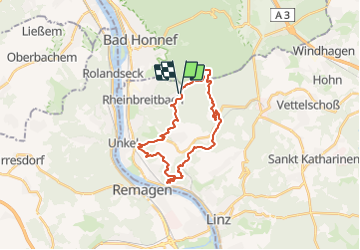
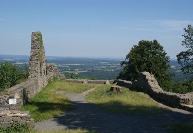
Randonnée Marche de 24 km à découvrir à Rhénanie-Palatinat, Landkreis Neuwied, Rheinbreitbach. Cette randonnée est proposée par flip96.
Description
Rondwandeling vanaf Waldblick 1 Rheinbreitbach. Prachtige wandeling langs Breitbach, Detzelbach en Kasbach. Mooi uitzicht vanaf de Leyberg en vanaf het Erpelleyplateau zicht op de Rijn.
Opmerkingen? flip96@home.nl
Localisation
Pays :
Allemagne
Région :
Rhénanie-Palatinat
Département/Province :
Landkreis Neuwied
Commune :
Rheinbreitbach
Localité :
Unknown
Départ:(Dec)
Départ:(UTM)
376533 ; 5609187 (32U) N.
Commentaires
Randonnées à proximité
![Randonnée A pied Bad Honnef - Rheinsteig-Zuweg Hövel/Aegidienberg - Photo](https://media.geolcdn.com/t/375/260/ext.jpg?maxdim=2&url=https%3A%2F%2Fmedia.geolcdn.com%2Ff%2F99836933-4e5f-4391-a379-7fbe9ae9cc1e.jpeg)
![A pied A pied](https://static1.geolcdn.com/sitytour/trail-icons/100.png)
Rheinsteig-Zuweg Hövel/Aegidienberg
A pied
Facile
Bad Honnef,
Rhénanie-du-Nord-Westphalie,
Rhein-Sieg-Kreis,
Allemagne
![](/images/other/stat-length.png)
6 km | 7,6 km-effort
1h 44min
![](https://static1.geolcdn.com/siteimages/upload/files/16400158638029165_repeat_loop_refresh_sync_direction_icon.png)
Non
![Randonnée A pied Bruchhausen - Rotbäckchen Rundwanderweg - Photo](https://media.geolcdn.com/t/375/260/ext.jpg?maxdim=2&url=https%3A%2F%2Fmedia.geolcdn.com%2Ff%2F1dd5c4a7-c3a6-459c-9cef-b7e5315b6005.jpeg)
![A pied A pied](https://static1.geolcdn.com/sitytour/trail-icons/100.png)
Rotbäckchen Rundwanderweg
A pied
Facile
Bruchhausen,
Rhénanie-Palatinat,
Landkreis Neuwied,
Allemagne
![](/images/other/stat-length.png)
11,1 km | 14,1 km-effort
3h 11min
![](https://static1.geolcdn.com/siteimages/upload/files/16400158638029165_repeat_loop_refresh_sync_direction_icon.png)
Oui
![Randonnée A pied Remagen - Apollinaris-Schleife (Rheinburgenweg Rundtour) - Photo](https://media.geolcdn.com/t/375/260/ext.jpg?maxdim=2&url=https%3A%2F%2Fmedia.geolcdn.com%2Ff%2Fafe28d54-8362-474d-8d66-b77f50c689dd.jpeg)
![A pied A pied](https://static1.geolcdn.com/sitytour/trail-icons/100.png)
Apollinaris-Schleife (Rheinburgenweg Rundtour)
A pied
Facile
Remagen,
Rhénanie-Palatinat,
Landkreis Ahrweiler,
Allemagne
![](/images/other/stat-length.png)
12,7 km | 16,4 km-effort
3h 43min
![](https://static1.geolcdn.com/siteimages/upload/files/16400158638029165_repeat_loop_refresh_sync_direction_icon.png)
Oui
![Randonnée A pied Remagen - [4] Oberwinter Rundwanderweg - Photo](https://media.geolcdn.com/t/375/260/ext.jpg?maxdim=2&url=https%3A%2F%2Fmedia.geolcdn.com%2Ff%2Fe27ef9e9-090e-4d77-ab64-ebc2130b65b2.jpeg)
![A pied A pied](https://static1.geolcdn.com/sitytour/trail-icons/100.png)
[4] Oberwinter Rundwanderweg
A pied
Facile
Remagen,
Rhénanie-Palatinat,
Landkreis Ahrweiler,
Allemagne
![](/images/other/stat-length.png)
4,9 km | 6,7 km-effort
1h 31min
![](https://static1.geolcdn.com/siteimages/upload/files/16400158638029165_repeat_loop_refresh_sync_direction_icon.png)
Oui
![Randonnée A pied Remagen - [5] Oberwinter Rundwanderweg - Photo](https://media.geolcdn.com/t/375/260/ext.jpg?maxdim=2&url=https%3A%2F%2Fmedia.geolcdn.com%2Ff%2Ff5d36974-2dd7-4709-98b7-1c99706d0ead.jpeg)
![A pied A pied](https://static1.geolcdn.com/sitytour/trail-icons/100.png)
[5] Oberwinter Rundwanderweg
A pied
Facile
Remagen,
Rhénanie-Palatinat,
Landkreis Ahrweiler,
Allemagne
![](/images/other/stat-length.png)
9,1 km | 13,1 km-effort
2h 58min
![](https://static1.geolcdn.com/siteimages/upload/files/16400158638029165_repeat_loop_refresh_sync_direction_icon.png)
Oui
![Randonnée A pied Remagen - Oberwinter Rundweg 2 - Photo](https://media.geolcdn.com/t/375/260/ext.jpg?maxdim=2&url=https%3A%2F%2Fmedia.geolcdn.com%2Ff%2F778735ff-4094-4e3b-aa07-2d8b179e4649.jpeg)
![A pied A pied](https://static1.geolcdn.com/sitytour/trail-icons/100.png)
Oberwinter Rundweg 2
A pied
Facile
Remagen,
Rhénanie-Palatinat,
Landkreis Ahrweiler,
Allemagne
![](/images/other/stat-length.png)
5,1 km | 6,6 km-effort
1h 29min
![](https://static1.geolcdn.com/siteimages/upload/files/16400158638029165_repeat_loop_refresh_sync_direction_icon.png)
Non
![Randonnée A pied Remagen - [1] Oberwinter Wanderweg (Oberwinter - Rolandseck) - Photo](https://media.geolcdn.com/t/375/260/ext.jpg?maxdim=2&url=https%3A%2F%2Fmedia.geolcdn.com%2Ff%2F25784967-1970-4af5-8d60-8f5ed7fdcfe9.jpeg)
![A pied A pied](https://static1.geolcdn.com/sitytour/trail-icons/100.png)
[1] Oberwinter Wanderweg (Oberwinter - Rolandseck)
A pied
Facile
Remagen,
Rhénanie-Palatinat,
Landkreis Ahrweiler,
Allemagne
![](/images/other/stat-length.png)
3,7 km | 5,2 km-effort
1h 10min
![](https://static1.geolcdn.com/siteimages/upload/files/16400158638029165_repeat_loop_refresh_sync_direction_icon.png)
Non
![Randonnée A pied Bad Honnef - Rheinsteig-Zuweg Bad Honnef (Nord) - Photo](https://media.geolcdn.com/t/375/260/ext.jpg?maxdim=2&url=https%3A%2F%2Fmedia.geolcdn.com%2Ff%2Fe60109cf-63fe-45d6-8fb4-6ccf1e16ec85.jpeg)
![A pied A pied](https://static1.geolcdn.com/sitytour/trail-icons/100.png)
Rheinsteig-Zuweg Bad Honnef (Nord)
A pied
Facile
Bad Honnef,
Rhénanie-du-Nord-Westphalie,
Rhein-Sieg-Kreis,
Allemagne
![](/images/other/stat-length.png)
4,2 km | 7 km-effort
1h 34min
![](https://static1.geolcdn.com/siteimages/upload/files/16400158638029165_repeat_loop_refresh_sync_direction_icon.png)
Non
![Randonnée A pied Vettelschoß - Rheinsteig-Zuweg Kalenborn - Photo](https://media.geolcdn.com/t/375/260/ext.jpg?maxdim=2&url=https%3A%2F%2Fmedia.geolcdn.com%2Ff%2Fc07369c5-ba12-49ff-983d-a7ba9bba008e.jpeg)
![A pied A pied](https://static1.geolcdn.com/sitytour/trail-icons/100.png)
Rheinsteig-Zuweg Kalenborn
A pied
Facile
Vettelschoß,
Rhénanie-Palatinat,
Landkreis Neuwied,
Allemagne
![](/images/other/stat-length.png)
7,5 km | 9,3 km-effort
2h 6min
![](https://static1.geolcdn.com/siteimages/upload/files/16400158638029165_repeat_loop_refresh_sync_direction_icon.png)
Non