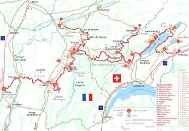
Randonnée Ski de fond Montlebon - GTJ complète ski de fond - Photo
 lbguigui
lbguigui

Utilisateur

© OpenStreetMap contributors
Longueur
Longueur
185 km
Altitude max
Altitude max
1407 m
Dénivelé positif
Dénivelé positif
4171 m
Km-Effort
Km-Effort  
241 km
Altitude min
Altitude min
907 m
Dénivelé négatif
Dénivelé négatif
4158 m
Boucle
Boucle
Non
Date de création :
2022-10-30 09:57:44.1
Dernière modification :
2022-11-17 13:19:13.045

(0 Avis)

Ski de fond
Ski de fond
0m
Difficulté : Difficile

Scannez ce code QR pour ouvrir la randonnée dans l'application SityTrail

Application GPS de randonnée GRATUITE

Logo SityTrail SityTrail

IGN / Instituts géographiques

Télécharger SityTrail sur l'App Store Télécharger SityTrail sur Google Play

Logo SityTrail SityTrail World

Le monde est à vous

Télécharger SityTrail sur l'App Store Télécharger SityTrail sur Google Play Télécharger SityTrail sur Huawei AppGallery

À propos

Randonnée Ski de fond de 185 km à découvrir à Bourgogne-Franche-Comté, Doubs, Montlebon. Cette randonnée est proposée par lbguigui.

Profil altimétrique

Points d'intérêt

Point d'intérêt Les Gras - Gîte Les seignes - Photo
lbguigui
Point d'intérêt Verrières-de-Joux - Le Tillau - Photo
lbguigui
VERRIÈRES-DE-JOUX 
Point d'intérêt Métabief - Appartement Booking - Photo
lbguigui
Point d'intérêt Mouthe - La Chaumière - Photo
lbguigui
Point d'intérêt Chapelle-des-Bois - La Maison du Montagnon - Photo
lbguigui
CHAPELLE-DES-BOIS 
Point d'intérêt Les Rousses - Le grenier des rousses - Photo
lbguigui
Point d'intérêt Lamoura - Chalet de La Frasse - Photo
lbguigui
Point d'intérêt Bellecombe - La Guienette - Photo
lbguigui
BELLECOMBE 

Localisation

Pays :
France
Région :
Bourgogne-Franche-Comté
Département/Province :
Doubs
Commune :
Montlebon
Localité :
Unknown
Départ:(Dec)
Départ:(UTM)
322959 ; 5212086 (32T) N.

Randonnées à proximité

Randonnée A pied Le Locle - Hôtel du Saut du Doubs - Gare des Brenets - Photo
A pied
GUIDE+

A pied

Facile
Le Locle, Neuchâtel, Inconnu, Suisse
3,1 km | 4,3 km-effort
58min
Non
Randonnée A pied Le Locle - Les Frêtes - fixme - Photo
A pied
GUIDE+

A pied

Facile
Le Locle, Neuchâtel, Inconnu, Suisse
4,1 km | 6,7 km-effort
1h 31min
Non
Randonnée A pied Le Locle - Les Frêtes - fixme - Photo
A pied
GUIDE+

A pied

Facile
Le Locle, Neuchâtel, Inconnu, Suisse
3,4 km | 5,8 km-effort
1h 19min
Non
Randonnée Marche Montlebon - montlebon - Photo
Marche
eltonnermou

Marche

Moyen
Montlebon, Bourgogne-Franche-Comté, Doubs, France
16,4 km | 23 km-effort
6h 1min
Oui
Randonnée Marche Morteau - Via Cluny: de Morteau (Montagnes du Jura) à Cluny (Bourgogne) - Photo
Marche
GUIDE
ViaCluny

Marche

Très difficile
Morteau, Bourgogne-Franche-Comté, Doubs, France
445 km | 590 km-effort
134h 8min
Non
Randonnée Cyclotourisme Les Fins - GTJ #2  - Photo
Cyclotourisme
GUIDE
David25400

Cyclotourisme

Difficile
Les Fins, Bourgogne-Franche-Comté, Doubs, France
103 km | 125 km-effort
9h 35min
Non
Randonnée Vélo de route Villers-le-Lac - VILLERS LE LAC - MORTEAU - PONTARLIER - JOUX - LE LOCLE - VILLERS LE LAC - Photo
Vélo de route
jean-marie.parachini

Vélo de route

Moyen
Villers-le-Lac, Bourgogne-Franche-Comté, Doubs, France
88 km | 108 km-effort
5h 26min
Oui
Randonnée Marche  - Montlebon Suisse La Brévine - Photo
Marche
i20

Marche

Moyen
, Bourgogne-Franche-Comté, Doubs, France
15,2 km | 22 km-effort
3h 19min
Oui
Randonnée Marche Le Locle - Marche 2019 - Colo - Photo
Marche
norbertmarteau

Marche

Très facile
Le Locle, Neuchâtel, Inconnu, Suisse
22 km | 34 km-effort
4h 54min
Non


Fermer
Mes abonnements