![](/images/other/stat-length.png)
![Randonnée Marche Maasgouw - Thorn _438 - Photo](https://media.geolcdn.com/t/1900/400/ext.pjpeg?maxdim=2&url=https%3A%2F%2Fstatic1.geolcdn.com%2Fsiteimages%2Fupload%2Ffiles%2F1553511878bg_sport_marche.png)
Thorn _438
mumu.larandonneuse
Utilisateur GUIDE
![Longueur](/images/other/stat-length.png)
![Altitude max](https://static1.geolcdn.com/siteimages/upload/files/1508320355ic_sort_altitude_max_24dp.png)
![Dénivelé positif](https://static1.geolcdn.com/siteimages/upload/files/1508320355ic_sort_den_pos_24dp.png)
![Km-Effort](/images/other/stat-length.png)
![Altitude min](https://static1.geolcdn.com/siteimages/upload/files/1508320355ic_sort_altitude_min_24dp.png)
![Dénivelé négatif](https://static1.geolcdn.com/siteimages/upload/files/1508320355ic_sort_den_neg_24dp.png)
![Boucle](https://static1.geolcdn.com/siteimages/upload/files/16400158638029165_repeat_loop_refresh_sync_direction_icon.png)
![Marche](https://static1.geolcdn.com/sitytour/trail-icons/101.png)
3h37
Difficulté : Très facile
![Scannez ce code QR pour ouvrir la randonnée dans l'application SityTrail](https://capi.geolives.com/qq0zvz2zws4bq2lad0pu/sitytour/trails/3437102/qr.png?size=200)
Application GPS de randonnée GRATUITE
À propos
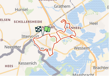
Randonnée Marche de 14,5 km à découvrir à Limbourg, Inconnu, Maasgouw. Cette randonnée est proposée par mumu.larandonneuse.
Description
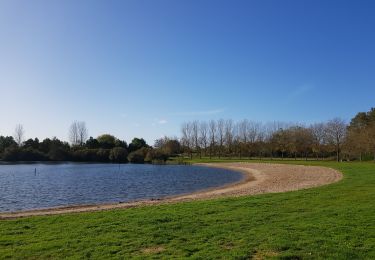
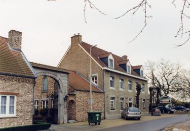
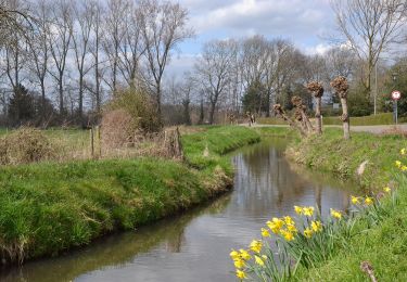
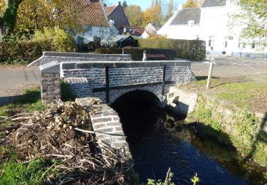
ℹ sur www.wandelgidszuidlimburg.com n° 438 ➡️ Cette promenade à plat est idéale pour explorer les environs de Thorn. L'itinéraire est sur des routes et des chemins bien entretenus et il y a beaucoup à voir. Le long de la belle chapelle Onder de Linden et de la chapelle Saint-Pierre, vous marchez jusqu'à la belle Leerkesven, que vous parcourez tout autour. Ensuite, vous longez la réserve naturelle de Meggelveld jusqu'à la pittoresque ville blanche de Thorn, que vous traversez un peu. Vous pouvez faire une pause au restaurant De Pannenkoekenbakker. La dernière partie le long du ruisseau et de la réserve naturelle de Vijverbroek est magnifique.
.
Localisation
Commentaires
Randonnées à proximité
![Randonnée Marche Maasgouw - Thorn - Kessenich - Photo](https://media.geolcdn.com/t/375/260/6721e024-f911-400b-93a1-010902f29dc2.jpg&format=jpg&maxdim=2)
![Marche Marche](https://static1.geolcdn.com/sitytour/trail-icons/101.png)
Marche
![](/images/other/stat-length.png)
![](https://static1.geolcdn.com/siteimages/upload/files/16400158638029165_repeat_loop_refresh_sync_direction_icon.png)
![Randonnée A pied Maasgouw - Molenplas - Photo](https://media.geolcdn.com/t/375/260/a9d73bcd-1373-4487-bc1e-2ba7100eaa25.jpeg&format=jpg&maxdim=2)
![A pied A pied](https://static1.geolcdn.com/sitytour/trail-icons/100.png)
![Randonnée A pied Kinrooi - Aldeneik & Maaseik Oranje bol - Photo](https://media.geolcdn.com/t/375/260/bc3af69e-279e-4557-9451-37c2a56c35ef.jpeg&format=jpg&maxdim=2)
![A pied A pied](https://static1.geolcdn.com/sitytour/trail-icons/100.png)
A pied
![](/images/other/stat-length.png)
![](https://static1.geolcdn.com/siteimages/upload/files/16400158638029165_repeat_loop_refresh_sync_direction_icon.png)
![Randonnée A pied Maasgouw - Kessenich en de Drie Eigen Rode driehoek - Photo](https://media.geolcdn.com/t/375/260/77b59905-a12f-4e43-9213-9afcc0b2276d.jpeg&format=jpg&maxdim=2)
![A pied A pied](https://static1.geolcdn.com/sitytour/trail-icons/100.png)
A pied
![](/images/other/stat-length.png)
![](https://static1.geolcdn.com/siteimages/upload/files/16400158638029165_repeat_loop_refresh_sync_direction_icon.png)
![Randonnée A pied Kinrooi - Kessenich en de Drie Eigen Paarse boot - Photo](https://media.geolcdn.com/t/375/260/24e2bd97-c890-4906-9b76-50b358b1ffd3.jpeg&format=jpg&maxdim=2)
![A pied A pied](https://static1.geolcdn.com/sitytour/trail-icons/100.png)
A pied
![](/images/other/stat-length.png)
![](https://static1.geolcdn.com/siteimages/upload/files/16400158638029165_repeat_loop_refresh_sync_direction_icon.png)
![Randonnée A pied Kinrooi - Kessenich en de Drie Eigen Groene rechthoek - Photo](https://media.geolcdn.com/t/375/260/d906b2b2-a7df-4af2-abfb-db8e706c3f74.jpeg&format=jpg&maxdim=2)
![A pied A pied](https://static1.geolcdn.com/sitytour/trail-icons/100.png)
A pied
![](/images/other/stat-length.png)
![](https://static1.geolcdn.com/siteimages/upload/files/16400158638029165_repeat_loop_refresh_sync_direction_icon.png)
![Randonnée A pied Maasgouw - Kessenich en de Drie Eigen Blauwe ruit - Photo](https://media.geolcdn.com/t/375/260/7a0d588c-2664-4335-b354-fe14498d3c96.jpeg&format=jpg&maxdim=2)
![A pied A pied](https://static1.geolcdn.com/sitytour/trail-icons/100.png)
A pied
![](/images/other/stat-length.png)
![](https://static1.geolcdn.com/siteimages/upload/files/16400158638029165_repeat_loop_refresh_sync_direction_icon.png)
![Randonnée Voilier Kinrooi - boot op de Maas - Photo](https://media.geolcdn.com/t/375/260/ext.jpg?maxdim=2&url=https%3A%2F%2Fsecurestorage.geolives.com%2Fsitytour%2Ftrail-bg%2Fdefault.jpg)
![Voilier Voilier](https://static1.geolcdn.com/sitytour/trail-icons/702.png)
Voilier
![](/images/other/stat-length.png)
![](https://static1.geolcdn.com/siteimages/upload/files/16400158638029165_repeat_loop_refresh_sync_direction_icon.png)
![Randonnée Vélo Leudal - Limburg - Leudalroute - Photo](https://media.geolcdn.com/t/375/260/ext.jpg?maxdim=2&url=https%3A%2F%2Fstatic1.geolcdn.com%2Fsiteimages%2Fupload%2Ffiles%2F1524743154velo.jpg)
![Vélo Vélo](https://static1.geolcdn.com/sitytour/trail-icons/200.png)
Vélo
![](/images/other/stat-length.png)
![](https://static1.geolcdn.com/siteimages/upload/files/16400158638029165_repeat_loop_refresh_sync_direction_icon.png)