![](/images/other/stat-length.png)
![Randonnée Marche Vodable - Vodable_Ronzieres - Photo](https://media.geolcdn.com/t/1900/400/212d647d-7980-4e4c-8c90-025466bfa64e.jpg&format=pjpeg&maxdim=2)
Vodable_Ronzieres
jagarnier
Utilisateur GUIDE
![Longueur](/images/other/stat-length.png)
Longueur
12,8 km
![Altitude max](https://static1.geolcdn.com/siteimages/upload/files/1508320355ic_sort_altitude_max_24dp.png)
Altitude max
841 m
![Dénivelé positif](https://static1.geolcdn.com/siteimages/upload/files/1508320355ic_sort_den_pos_24dp.png)
Dénivelé positif
392 m
![Km-Effort](/images/other/stat-length.png)
Km-Effort
18 km
![Altitude min](https://static1.geolcdn.com/siteimages/upload/files/1508320355ic_sort_altitude_min_24dp.png)
Altitude min
658 m
![Dénivelé négatif](https://static1.geolcdn.com/siteimages/upload/files/1508320355ic_sort_den_neg_24dp.png)
Dénivelé négatif
390 m
![Boucle](https://static1.geolcdn.com/siteimages/upload/files/16400158638029165_repeat_loop_refresh_sync_direction_icon.png)
Boucle
Oui
Date de création :
2022-10-26 12:28:42.118
Dernière modification :
2022-12-16 11:06:53.43
![Marche](https://static1.geolcdn.com/sitytour/trail-icons/101.png)
3h45
Difficulté : Moyen
![Scannez ce code QR pour ouvrir la randonnée dans l'application SityTrail](https://capi.geolives.com/qq0zvz2zws4bq2lad0pu/sitytour/trails/3436144/qr.png?size=200)
Application GPS de randonnée GRATUITE
À propos
Randonnée Marche de 12,8 km à découvrir à Auvergne-Rhône-Alpes, Puy-de-Dôme, Vodable. Cette randonnée est proposée par jagarnier.
Description
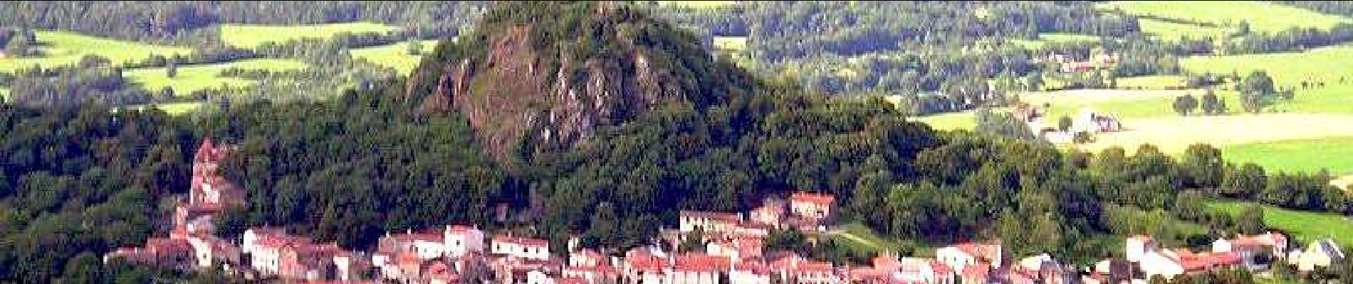
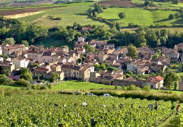
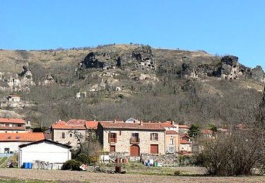
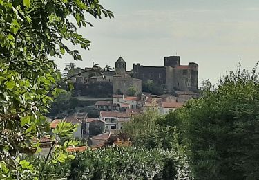
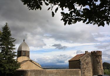
Au cœur du Lembron, terre d'anciens volcans et de coulées de lave, le village de Ronzières s'enroule autour d'une butte basaltique. Fier de son oppidum, cette place forte fut utilisée dès le premier millénaire avant notre ère.
Localisation
Pays :
France
Région :
Auvergne-Rhône-Alpes
Département/Province :
Puy-de-Dôme
Commune :
Vodable
Localité :
Unknown
Départ:(Dec)
Départ:(UTM)
511249 ; 5039419 (31T) N.
Commentaires
Randonnées à proximité
![Randonnée Marche Villeneuve - Villeneuve_Boudes_Chalus - Photo](https://media.geolcdn.com/t/375/260/fa4d9ad2-0c04-4754-942b-a8352fff5676.jpg&format=jpg&maxdim=2)
![Marche Marche](https://static1.geolcdn.com/sitytour/trail-icons/101.png)
Villeneuve_Boudes_Chalus
Marche
Moyen
(1)
Villeneuve,
Auvergne-Rhône-Alpes,
Puy-de-Dôme,
France
![](/images/other/stat-length.png)
8,9 km | 13,2 km-effort
2h 45min
![](https://static1.geolcdn.com/siteimages/upload/files/16400158638029165_repeat_loop_refresh_sync_direction_icon.png)
Oui
![Randonnée Marche Saint-Vincent - St_Vincent_Puy_Lavelle - Photo](https://media.geolcdn.com/t/375/260/a3fc96ef-efb3-4784-a23c-0f44c0b5ca63.jpg&format=jpg&maxdim=2)
![Marche Marche](https://static1.geolcdn.com/sitytour/trail-icons/101.png)
St_Vincent_Puy_Lavelle
Marche
Moyen
(2)
Saint-Vincent,
Auvergne-Rhône-Alpes,
Puy-de-Dôme,
France
![](/images/other/stat-length.png)
10,1 km | 14,9 km-effort
3h 0min
![](https://static1.geolcdn.com/siteimages/upload/files/16400158638029165_repeat_loop_refresh_sync_direction_icon.png)
Oui
![Randonnée Marche Perrier - Perrier_Grottes - Photo](https://media.geolcdn.com/t/375/260/ca8c1099-b88e-49ae-bfce-483cc02ee603.jpg&format=jpg&maxdim=2)
![Marche Marche](https://static1.geolcdn.com/sitytour/trail-icons/101.png)
Perrier_Grottes
Marche
Facile
(1)
Perrier,
Auvergne-Rhône-Alpes,
Puy-de-Dôme,
France
![](/images/other/stat-length.png)
7,3 km | 10 km-effort
2h 15min
![](https://static1.geolcdn.com/siteimages/upload/files/16400158638029165_repeat_loop_refresh_sync_direction_icon.png)
Oui
![Randonnée A pied Boudes - Villeneuve, Boudes, Chalus - Photo](https://media.geolcdn.com/t/375/260/9a83dcb2-377f-43a0-8436-358d4c634f72.jpeg&format=jpg&maxdim=2)
![A pied A pied](https://static1.geolcdn.com/sitytour/trail-icons/100.png)
Villeneuve, Boudes, Chalus
A pied
Facile
Boudes,
Auvergne-Rhône-Alpes,
Puy-de-Dôme,
France
![](/images/other/stat-length.png)
9 km | 13,3 km-effort
3h 0min
![](https://static1.geolcdn.com/siteimages/upload/files/16400158638029165_repeat_loop_refresh_sync_direction_icon.png)
Oui
![Randonnée A pied Mareugheol - La Chaux et le Bois de Jaby - Photo](https://media.geolcdn.com/t/375/260/d7ed3937-d9f3-475d-9b76-187d38d4bf46.jpeg&format=jpg&maxdim=2)
![A pied A pied](https://static1.geolcdn.com/sitytour/trail-icons/100.png)
La Chaux et le Bois de Jaby
A pied
Facile
Mareugheol,
Auvergne-Rhône-Alpes,
Puy-de-Dôme,
France
![](/images/other/stat-length.png)
10,1 km | 13,7 km-effort
3h 7min
![](https://static1.geolcdn.com/siteimages/upload/files/16400158638029165_repeat_loop_refresh_sync_direction_icon.png)
Oui
![Randonnée A pied Dauzat-sur-Vodable - Dauzat-sur-Vodable - Photo](https://media.geolcdn.com/t/375/260/d172e481-65da-4881-bd03-f6cc99def315.jpeg&format=jpg&maxdim=2)
![A pied A pied](https://static1.geolcdn.com/sitytour/trail-icons/100.png)
Dauzat-sur-Vodable
A pied
Facile
Dauzat-sur-Vodable,
Auvergne-Rhône-Alpes,
Puy-de-Dôme,
France
![](/images/other/stat-length.png)
10 km | 14,7 km-effort
3h 20min
![](https://static1.geolcdn.com/siteimages/upload/files/16400158638029165_repeat_loop_refresh_sync_direction_icon.png)
Oui
![Randonnée A pied Saint-Floret - La Chaubasse - Photo](https://media.geolcdn.com/t/375/260/768fec42-41d9-4005-9393-314a0342ff62.jpeg&format=jpg&maxdim=2)
![A pied A pied](https://static1.geolcdn.com/sitytour/trail-icons/100.png)
La Chaubasse
A pied
Facile
Saint-Floret,
Auvergne-Rhône-Alpes,
Puy-de-Dôme,
France
![](/images/other/stat-length.png)
9,4 km | 14,2 km-effort
3h 13min
![](https://static1.geolcdn.com/siteimages/upload/files/16400158638029165_repeat_loop_refresh_sync_direction_icon.png)
Oui
![Randonnée A pied Villeneuve - Vodable et Colamine - Photo](https://media.geolcdn.com/t/375/260/fd9aa514-9038-4f51-9473-e7a8f5ea4688.jpeg&format=jpg&maxdim=2)
![A pied A pied](https://static1.geolcdn.com/sitytour/trail-icons/100.png)
Vodable et Colamine
A pied
Facile
Villeneuve,
Auvergne-Rhône-Alpes,
Puy-de-Dôme,
France
![](/images/other/stat-length.png)
12 km | 16,6 km-effort
3h 45min
![](https://static1.geolcdn.com/siteimages/upload/files/16400158638029165_repeat_loop_refresh_sync_direction_icon.png)
Non
![Randonnée A pied Tourzel-Ronzières - Les Cinq Villages - Photo](https://media.geolcdn.com/t/375/260/3398564d-d4fb-4353-84f0-628dcc0a106c.jpeg&format=jpg&maxdim=2)
![A pied A pied](https://static1.geolcdn.com/sitytour/trail-icons/100.png)
Les Cinq Villages
A pied
Facile
Tourzel-Ronzières,
Auvergne-Rhône-Alpes,
Puy-de-Dôme,
France
![](/images/other/stat-length.png)
13,2 km | 18,3 km-effort
4h 9min
![](https://static1.geolcdn.com/siteimages/upload/files/16400158638029165_repeat_loop_refresh_sync_direction_icon.png)
Oui