Randonnée Marche Ochagavía/Otsagabia - valle de roncal - Photo
 kmouflet
kmouflet

Utilisateur

© OpenStreetMap contributors
Longueur
Longueur
32 km
Altitude max
Altitude max
1482 m
Dénivelé positif
Dénivelé positif
592 m
Km-Effort
Km-Effort  
42 km
Altitude min
Altitude min
782 m
Dénivelé négatif
Dénivelé négatif
1120 m
Boucle
Boucle
Non
Date de création :
2022-10-23 13:31:16.971
Dernière modification :
2022-10-23 17:49:07.342

(0 Avis)

Marche
Marche
4h17
Difficulté : Très difficile

Scannez ce code QR pour ouvrir la randonnée dans l'application SityTrail

Application GPS de randonnée GRATUITE

Logo SityTrail SityTrail

IGN / Instituts géographiques

Télécharger SityTrail sur l'App Store Télécharger SityTrail sur Google Play

Logo SityTrail SityTrail World

Le monde est à vous

Télécharger SityTrail sur l'App Store Télécharger SityTrail sur Google Play Télécharger SityTrail sur Huawei AppGallery

À propos

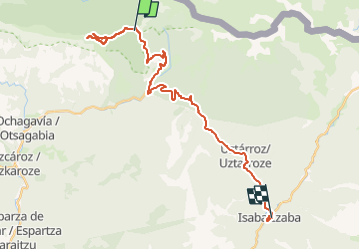
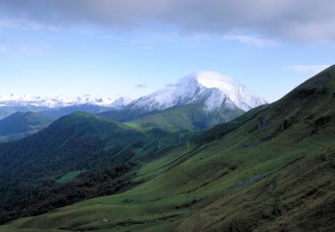
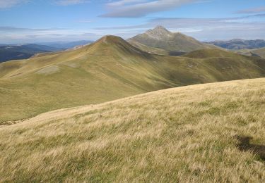
Randonnée Marche de 32 km à découvrir à Navarre, Inconnu, Ochagavía/Otsagabia. Cette randonnée est proposée par kmouflet.

Profil altimétrique

Photos

Localisation

Pays :
Espagne
Région :
Navarre
Département/Province :
Inconnu
Commune :
Ochagavía/Otsagabia
Localité :
Unknown
Départ:(UTM)
661788 ; 4757851 (30T) N.

Randonnées à proximité

Randonnée Marche Larrau - Le Pic d'Orhy par le Port de Larrau - Photo
Marche
tracegps

Marche

Difficile
(2)
Larrau, Nouvelle-Aquitaine, Pyrénées-Atlantiques, France
2,3 km | 6,6 km-effort
2h 0min
Non
Randonnée Marche Ochagavía/Otsagabia - ours - Photo
Marche
LouisROGER

Marche

Facile
Ochagavía/Otsagabia, Navarre, Inconnu, Espagne
15,2 km | 24 km-effort
6h 32min
Oui
Randonnée Marche Larrau - Pic d' Orhy en boucle par le col d' Erroimendi - Photo
Marche
benat40

Marche

Difficile
Larrau, Nouvelle-Aquitaine, Pyrénées-Atlantiques, France
6,1 km | 14,9 km-effort
2h 53min
Oui
Randonnée Marche Ochagavía/Otsagabia - Pic d'Orhy et crêtes frontalières  - Photo
Marche
pacha56

Marche

Moyen
Ochagavía/Otsagabia, Navarre, Inconnu, Espagne
7,5 km | 0 m-effort
4h 2min
Oui
Randonnée Ski de randonnée Ochagavía/Otsagabia - orhy descente  - Photo
Ski de randonnée
olivierGPS

Ski de randonnée

Très facile
Ochagavía/Otsagabia, Navarre, Inconnu, Espagne
7,5 km | 11,4 km-effort
1h 59min
Non
Randonnée Marche Larrau -  Le Gaztemgagna - G3 - Photo
Marche
mitch1952

Marche

Difficile
Larrau, Nouvelle-Aquitaine, Pyrénées-Atlantiques, France
9,8 km | 17,6 km-effort
3h 59min
Oui
Randonnée Marche Larrau - olhadoko - Photo
Marche
Beguet

Marche

Très facile
Larrau, Nouvelle-Aquitaine, Pyrénées-Atlantiques, France
11,3 km | 18,3 km-effort
5h 0min
Oui
Randonnée Marche Larrau - pic d orhy - Photo
Marche
vbe

Marche

Moyen
Larrau, Nouvelle-Aquitaine, Pyrénées-Atlantiques, France
5,4 km | 11,1 km-effort
4h 2min
Oui
Randonnée Marche Larrau - StEngrace_Lapierre - Photo
Marche
jakos

Marche

Très facile
Larrau, Nouvelle-Aquitaine, Pyrénées-Atlantiques, France
2,3 km | 6,6 km-effort
1h 36min
Non


Fermer
Mes abonnements