![](/images/other/stat-length.png)
![Randonnée Marche Espeluche - Bois-Jamot-Espeluche 11km - Photo](https://media.geolcdn.com/t/1900/400/799cda92-0993-44e5-bfc9-d42f9f871bf2.jpg&format=pjpeg&maxdim=2)
Bois-Jamot-Espeluche 11km
chancha
Utilisateur GUIDE
![Longueur](/images/other/stat-length.png)
Longueur
11,3 km
![Altitude max](https://static1.geolcdn.com/siteimages/upload/files/1508320355ic_sort_altitude_max_24dp.png)
Altitude max
405 m
![Dénivelé positif](https://static1.geolcdn.com/siteimages/upload/files/1508320355ic_sort_den_pos_24dp.png)
Dénivelé positif
308 m
![Km-Effort](/images/other/stat-length.png)
Km-Effort
15,4 km
![Altitude min](https://static1.geolcdn.com/siteimages/upload/files/1508320355ic_sort_altitude_min_24dp.png)
Altitude min
161 m
![Dénivelé négatif](https://static1.geolcdn.com/siteimages/upload/files/1508320355ic_sort_den_neg_24dp.png)
Dénivelé négatif
309 m
![Boucle](https://static1.geolcdn.com/siteimages/upload/files/16400158638029165_repeat_loop_refresh_sync_direction_icon.png)
Boucle
Oui
Date de création :
2022-10-20 13:14:37.242
Dernière modification :
2022-10-20 16:35:52.084
![Marche](https://static1.geolcdn.com/sitytour/trail-icons/101.png)
3h28
Difficulté : Moyen
![Scannez ce code QR pour ouvrir la randonnée dans l'application SityTrail](https://capi.geolives.com/qq0zvz2zws4bq2lad0pu/sitytour/trails/3429789/qr.png?size=200)
Application GPS de randonnée GRATUITE
À propos
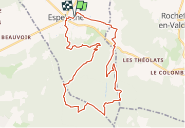
Randonnée Marche de 11,3 km à découvrir à Auvergne-Rhône-Alpes, Drôme, Espeluche. Cette randonnée est proposée par chancha.
Description
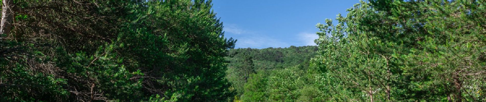
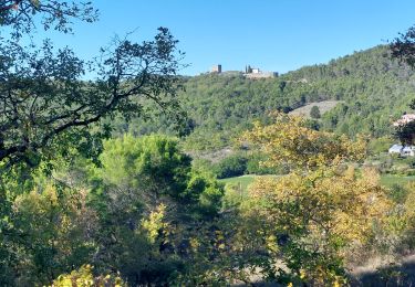
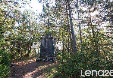
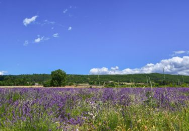
Entre chemins forestiers et sentiers en crête , le bois Jamot offre de jolis points de vue sur le château medieval de Rochefort-en-Valdaine ainsi que la vallée du Rhône . Une randonnée accessible et majoritairement ombragée .
Localisation
Pays :
France
Région :
Auvergne-Rhône-Alpes
Département/Province :
Drôme
Commune :
Espeluche
Localité :
Unknown
Départ:(Dec)
Départ:(UTM)
645132 ; 4930863 (31T) N.
Commentaires
Randonnées à proximité
![Randonnée Marche Rochefort-en-Valdaine - Rochefort-en-Valdaine Le Janeston 7km5 - Photo](https://media.geolcdn.com/t/375/260/c37954dd-2a13-465c-a79c-9622f5a3d882.jpg&format=jpg&maxdim=2)
![Marche Marche](https://static1.geolcdn.com/sitytour/trail-icons/101.png)
Rochefort-en-Valdaine Le Janeston 7km5
Marche
Moyen
(1)
Rochefort-en-Valdaine,
Auvergne-Rhône-Alpes,
Drôme,
France
![](/images/other/stat-length.png)
7,3 km | 10,3 km-effort
2h 23min
![](https://static1.geolcdn.com/siteimages/upload/files/16400158638029165_repeat_loop_refresh_sync_direction_icon.png)
Oui
![Randonnée Marche Allan - allan transclavienne rac - Photo](https://media.geolcdn.com/t/375/260/ext.jpg?maxdim=2&url=https%3A%2F%2Fservices.sitytrail.com%2FGeolivesWS%2FDownloadMedia.ashx%3FTrailID%3D649381%26Media%3Dfix__20161022171755.jpg)
![Marche Marche](https://static1.geolcdn.com/sitytour/trail-icons/101.png)
allan transclavienne rac
Marche
Très facile
(1)
Allan,
Auvergne-Rhône-Alpes,
Drôme,
France
![](/images/other/stat-length.png)
19,1 km | 26 km-effort
5h 11min
![](https://static1.geolcdn.com/siteimages/upload/files/16400158638029165_repeat_loop_refresh_sync_direction_icon.png)
Oui
![Randonnée Marche La Touche - La Touche Crêtes de l'ysard 12km. - Photo](https://media.geolcdn.com/t/375/260/b7717e93-9def-4e5d-8328-3e96528d5925.jpg&format=jpg&maxdim=2)
![Marche Marche](https://static1.geolcdn.com/sitytour/trail-icons/101.png)
La Touche Crêtes de l'ysard 12km.
Marche
Difficile
(1)
La Touche,
Auvergne-Rhône-Alpes,
Drôme,
France
![](/images/other/stat-length.png)
12,1 km | 16,8 km-effort
3h 48min
![](https://static1.geolcdn.com/siteimages/upload/files/16400158638029165_repeat_loop_refresh_sync_direction_icon.png)
Oui
![Randonnée V.T.T. Puygiron - Puygiron VTT n°5 - Photo](https://media.geolcdn.com/t/375/260/ext.jpg?maxdim=2&url=https%3A%2F%2Fservices.sitytrail.com%2FGeolivesWS%2FDownloadMedia.ashx%3FTrailID%3D104845%26Media%3D8346_2.jpg)
![V.T.T. V.T.T.](https://static1.geolcdn.com/sitytour/trail-icons/202.png)
Puygiron VTT n°5
V.T.T.
Très difficile
(1)
Puygiron,
Auvergne-Rhône-Alpes,
Drôme,
France
![](/images/other/stat-length.png)
47 km | 60 km-effort
3h 0min
![](https://static1.geolcdn.com/siteimages/upload/files/16400158638029165_repeat_loop_refresh_sync_direction_icon.png)
Oui
![Randonnée Marche La Touche - La Touche : Les Citelles et Serre Pointu 12km - Photo](https://media.geolcdn.com/t/375/260/6be75cc0-9945-4cf3-b3f9-69a08db1d316.jpg&format=jpg&maxdim=2)
![Marche Marche](https://static1.geolcdn.com/sitytour/trail-icons/101.png)
La Touche : Les Citelles et Serre Pointu 12km
Marche
Difficile
La Touche,
Auvergne-Rhône-Alpes,
Drôme,
France
![](/images/other/stat-length.png)
12 km | 16,6 km-effort
4h 3min
![](https://static1.geolcdn.com/siteimages/upload/files/16400158638029165_repeat_loop_refresh_sync_direction_icon.png)
Oui
![Randonnée Marche La Touche - La Touche Mastaize 9km - Photo](https://media.geolcdn.com/t/375/260/7617f59d-4270-4583-9eab-9f2081c0076a.jpg&format=jpg&maxdim=2)
![Marche Marche](https://static1.geolcdn.com/sitytour/trail-icons/101.png)
La Touche Mastaize 9km
Marche
Difficile
La Touche,
Auvergne-Rhône-Alpes,
Drôme,
France
![](/images/other/stat-length.png)
8,6 km | 10,7 km-effort
3h 24min
![](https://static1.geolcdn.com/siteimages/upload/files/16400158638029165_repeat_loop_refresh_sync_direction_icon.png)
Oui
![Marche Marche](https://static1.geolcdn.com/sitytour/trail-icons/101.png)
Allan La Croix de Siméon 11km
Marche
Moyen
Allan,
Auvergne-Rhône-Alpes,
Drôme,
France
![](/images/other/stat-length.png)
10,7 km | 15,2 km-effort
3h 27min
![](https://static1.geolcdn.com/siteimages/upload/files/16400158638029165_repeat_loop_refresh_sync_direction_icon.png)
Oui
![Randonnée Marche Espeluche - Le Huit d'Espeluche 7km4 - Photo](https://media.geolcdn.com/t/375/260/7d9cd8c2-7377-40ec-9100-181655b047cd.jpg&format=jpg&maxdim=2)
![Marche Marche](https://static1.geolcdn.com/sitytour/trail-icons/101.png)
Le Huit d'Espeluche 7km4
Marche
Moyen
Espeluche,
Auvergne-Rhône-Alpes,
Drôme,
France
![](/images/other/stat-length.png)
8 km | 10,2 km-effort
2h 9min
![](https://static1.geolcdn.com/siteimages/upload/files/16400158638029165_repeat_loop_refresh_sync_direction_icon.png)
Oui
![Randonnée Marche Puygiron - Puygiron Coste Chaude 7km - Photo](https://media.geolcdn.com/t/375/260/0d0cf363-5e9d-4b75-83e8-04f87bc5f99f.jpg&format=jpg&maxdim=2)
![Marche Marche](https://static1.geolcdn.com/sitytour/trail-icons/101.png)
Puygiron Coste Chaude 7km
Marche
Facile
Puygiron,
Auvergne-Rhône-Alpes,
Drôme,
France
![](/images/other/stat-length.png)
6,9 km | 8,6 km-effort
1h 58min
![](https://static1.geolcdn.com/siteimages/upload/files/16400158638029165_repeat_loop_refresh_sync_direction_icon.png)
Oui