![](/images/other/stat-length.png)
“Sentier des Dieux“ CAI327+CAI331 Bomerano-Nocelle-Arienzo-Positano D+450m D-1000m
ericberlin
Utilisateur
![Longueur](/images/other/stat-length.png)
![Altitude max](https://static1.geolcdn.com/siteimages/upload/files/1508320355ic_sort_altitude_max_24dp.png)
![Dénivelé positif](https://static1.geolcdn.com/siteimages/upload/files/1508320355ic_sort_den_pos_24dp.png)
![Km-Effort](/images/other/stat-length.png)
![Altitude min](https://static1.geolcdn.com/siteimages/upload/files/1508320355ic_sort_altitude_min_24dp.png)
![Dénivelé négatif](https://static1.geolcdn.com/siteimages/upload/files/1508320355ic_sort_den_neg_24dp.png)
![Boucle](https://static1.geolcdn.com/siteimages/upload/files/16400158638029165_repeat_loop_refresh_sync_direction_icon.png)
![Marche](https://static1.geolcdn.com/sitytour/trail-icons/101.png)
3h49
Difficulté : Moyen
![Scannez ce code QR pour ouvrir la randonnée dans l'application SityTrail](https://capi.geolives.com/qq0zvz2zws4bq2lad0pu/sitytour/trails/3428601/qr.png?size=200)
Application GPS de randonnée GRATUITE
À propos
Randonnée Marche de 8,4 km à découvrir à Campanie, Napoli, Agerola. Cette randonnée est proposée par ericberlin.
Description
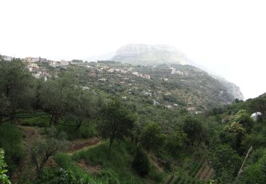
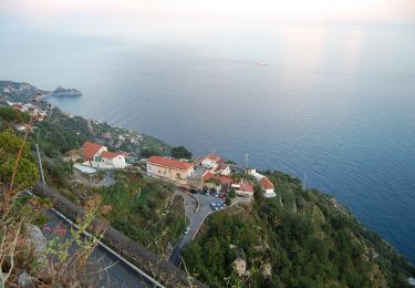
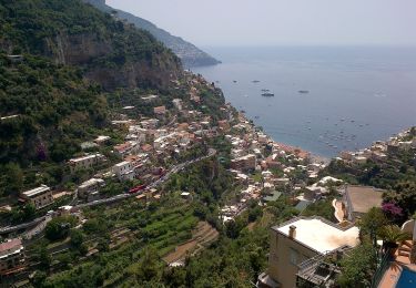
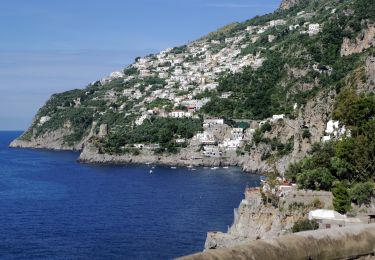
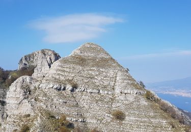
Une merveille ce Sentier des Dieux appelé Sentiero Degli Dei ou Path of Gods
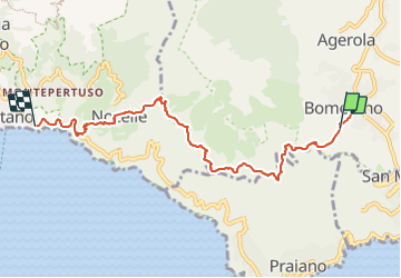
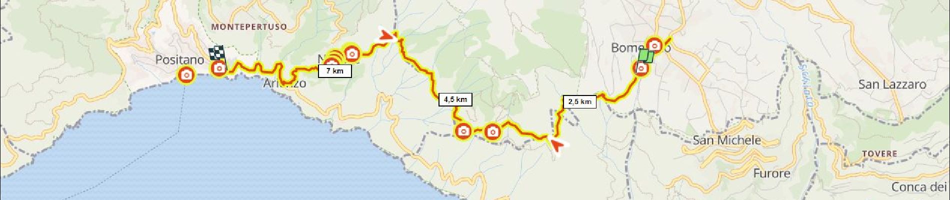
2h de Bomerano à Nocelle, suivre les balises CAI327 ou marquage rouge et blanc.
1h de Nocelle à Positano (CAI331) avec 2 variantes :
a) descente de Nocelle à Arienzo par les marches (1600 ). marquage rouge et blanc direction sud.
b) descente de Nocelle à Positano par la corniche de Montepertuzo -en partie par la route Vito Talamo-. marquage rouge et blanc direction nord
Accès au départ en bus, ligne depuis Amalfi vers Agerola, stop à Bomerola
(privilégier le départ du bus à 7h10 depuis Amalfi, moins de monde, belle lumière et fraicheur)
- Epicerie, bar et magasin d'articles de rando à Bomerola.
- Epicerie-bar sympa à Nocelle.
- Arrêt de bus et plage à Arienzo
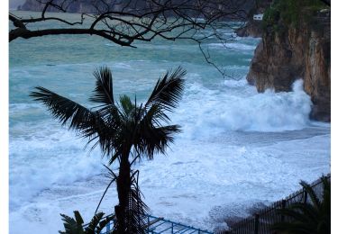
- Plage, restos à Positano, bus ou ferry pour retour à Amalfi.
Sentier en corniche plein sud avec peu d'ombre. Prévoir de bonnes chaussures -pierres glissantes-, eau, chapeau, carte -certaines bifurcations restent ambigües-
Eviter les journées chaudes ou sans visibilité -ce serait si dommage de le faire avec de la brume-.
Carte topo et remerciements au Club Alpin Italien: https://www.caimontilattari.it/en/sentiero/327/
https://www.caimontilattari.it/en/sentiero/331/
Bus:
https://www.sitasudtrasporti.it/orari
Un sentier qui mérite son nom et sa réputation.
Commentaires bienvenus, merci.
____________
The Path Of Gods (Sentiero Degli Dei) is a must for hikkers!
2 hours from Bomerano to Nocelle Follow the red and white marks or CAI327.
1 hour from Nocelle to Positano with 2 variants:
a) descent from Nocelle to Arienzo across the steps (1600 ).
Red and white marks, South direction (CAI331 path)
b) descent from Nocelle to Positano via the Montepertuzo ledge -partly with Vito Talamo road-.
Red and white marks, North direction (CAI331 path)
Access to departure by bus from Amalfi to Agerola, stop in Bomerola.
(prefer the departure of the bus at 7:10 am from Amalfi, less people, morning light, fresher temperature)
- Grocery store, bar and hiking gear store in Bomerola.
- Grocery-bar in Nocelle.
- Bus stop and beach in Arienzo
- Beach, many restaurants in Positano, bus or ferry for return to Amalfi.
South facing ledge trail with few shade.
Bring good shoes -slippery stones-, water, hat, map -some junctions are still poorly marked-
Avoid hot days or days with mist.
Maps and credit to CAI: https://www.caimontilattari.it/en/sentiero/327/
https://www.caimontilattari.it/en/sentiero/331/
Bus:
https://www.sitasudtrasporti.it/orari
Enjoy! Comment appreciated thank you.
Localisation
Commentaires
Randonnées à proximité
![Randonnée A pied Pimonte - (SI S20S) Faito - Colli di Fontanelle - Photo](https://media.geolcdn.com/t/375/260/339a2cc3-d44c-4b10-99bc-d3ad4eacfe08.jpeg&format=jpg&maxdim=2)
![A pied A pied](https://static1.geolcdn.com/sitytour/trail-icons/100.png)
A pied
![](/images/other/stat-length.png)
![](https://static1.geolcdn.com/siteimages/upload/files/16400158638029165_repeat_loop_refresh_sync_direction_icon.png)
![Randonnée A pied Agerola - Via Maestra dei Villaggi - Photo](https://media.geolcdn.com/t/375/260/1522fba5-8abc-4309-858f-0f6afdf484bf.jpeg&format=jpg&maxdim=2)
![A pied A pied](https://static1.geolcdn.com/sitytour/trail-icons/100.png)
A pied
![](/images/other/stat-length.png)
![](https://static1.geolcdn.com/siteimages/upload/files/16400158638029165_repeat_loop_refresh_sync_direction_icon.png)
![Randonnée A pied Scala - Sentiero dei Castagneti di Tavernate - Photo](https://media.geolcdn.com/t/375/260/99c75066-dc76-4fb0-8504-116a41cbe8e2.jpeg&format=jpg&maxdim=2)
![A pied A pied](https://static1.geolcdn.com/sitytour/trail-icons/100.png)
A pied
![](/images/other/stat-length.png)
![](https://static1.geolcdn.com/siteimages/upload/files/16400158638029165_repeat_loop_refresh_sync_direction_icon.png)
![Randonnée A pied Agerola - IT-354 - Photo](https://media.geolcdn.com/t/375/260/2e388bd4-676c-40a4-b84e-9fed408488b6.jpeg&format=jpg&maxdim=2)
![A pied A pied](https://static1.geolcdn.com/sitytour/trail-icons/100.png)
![Randonnée A pied Positano - IT-331 - Photo](https://media.geolcdn.com/t/375/260/c6961cbb-7617-405e-a626-22aff9e39b85.jpeg&format=jpg&maxdim=2)
![A pied A pied](https://static1.geolcdn.com/sitytour/trail-icons/100.png)
![Randonnée A pied Furore - Sentiero dei Pipistrelli Impazziti - Photo](https://media.geolcdn.com/t/375/260/8f4fa053-ea96-443f-8e01-6d2ee8565707.jpeg&format=jpg&maxdim=2)
![A pied A pied](https://static1.geolcdn.com/sitytour/trail-icons/100.png)
A pied
![](/images/other/stat-length.png)
![](https://static1.geolcdn.com/siteimages/upload/files/16400158638029165_repeat_loop_refresh_sync_direction_icon.png)
![Randonnée A pied Scala - Sentiero alto della Valle delle Ferriere - Photo](https://media.geolcdn.com/t/375/260/4c413f0a-7a02-4b95-a2da-66ff449fe626.jpeg&format=jpg&maxdim=2)
![A pied A pied](https://static1.geolcdn.com/sitytour/trail-icons/100.png)
A pied
![](/images/other/stat-length.png)
![](https://static1.geolcdn.com/siteimages/upload/files/16400158638029165_repeat_loop_refresh_sync_direction_icon.png)
![Randonnée A pied Agerola - Sentiero alto degli dei - Photo](https://media.geolcdn.com/t/375/260/a4426916-9c4c-4b34-b07b-2acb38451ae0.jpeg&format=jpg&maxdim=2)
![A pied A pied](https://static1.geolcdn.com/sitytour/trail-icons/100.png)
A pied
![](/images/other/stat-length.png)
![](https://static1.geolcdn.com/siteimages/upload/files/16400158638029165_repeat_loop_refresh_sync_direction_icon.png)
![Randonnée A pied Agerola - Sentier des dieux - Photo](https://media.geolcdn.com/t/375/260/0d614155-241e-4a83-b1a1-5358e69826c5.jpeg&format=jpg&maxdim=2)
![A pied A pied](https://static1.geolcdn.com/sitytour/trail-icons/100.png)
A pied
![](/images/other/stat-length.png)
![](https://static1.geolcdn.com/siteimages/upload/files/16400158638029165_repeat_loop_refresh_sync_direction_icon.png)