Randonnée Marche Oslon - Marche 2022 du Téléthon 14 km Départ Oslon - Photo

Marche 2022 du Téléthon 14 km Départ Oslon

 grasgilbert
grasgilbert

Utilisateur

© OpenStreetMap contributors
Longueur
Longueur
14,2 km
Altitude max
Altitude max
196 m
Dénivelé positif
Dénivelé positif
73 m
Km-Effort
Km-Effort  
15,2 km
Altitude min
Altitude min
174 m
Dénivelé négatif
Dénivelé négatif
73 m
Boucle
Boucle
Oui
Date de création :
2022-10-18 13:48:33.586
Dernière modification :
2022-10-18 13:52:56.38

(1 Avis)

Marche
Marche
3h27
Difficulté : Difficile

Scannez ce code QR pour ouvrir la randonnée dans l'application SityTrail

Application GPS de randonnée GRATUITE

Logo SityTrail SityTrail

IGN / Instituts géographiques

Télécharger SityTrail sur l'App Store Télécharger SityTrail sur Google Play

Logo SityTrail SityTrail World

Le monde est à vous

Télécharger SityTrail sur l'App Store Télécharger SityTrail sur Google Play Télécharger SityTrail sur Huawei AppGallery

À propos

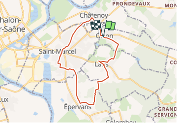
Randonnée Marche de 14,2 km à découvrir à Bourgogne-Franche-Comté, Saône-et-Loire, Oslon. Cette randonnée est proposée par grasgilbert.

Profil altimétrique

Localisation

Pays :
France
Région :
Bourgogne-Franche-Comté
Département/Province :
Saône-et-Loire
Commune :
Oslon
Localité :
Unknown
Départ:(UTM)
646533 ; 5182836 (31T) N.

Commentaires

Veuillez vous connecter pour laisser un commentaire ou une note


Randonnées à proximité

Randonnée Marche Châtenoy-en-Bresse - Golf  - Photo
Marche
jpdroux

Marche

Très difficile
Châtenoy-en-Bresse, Bourgogne-Franche-Comté, Saône-et-Loire, France
19,4 km | 21 km-effort
5h 1min
Non
Randonnée Vélo de route Saint-Marcel - mn06 - Photo
Vélo de route
berhin

Vélo de route

Moyen
Saint-Marcel, Bourgogne-Franche-Comté, Saône-et-Loire, France
24 km | 26 km-effort
2h 21min
Non
Randonnée Marche Châtenoy-en-Bresse - 20190524 Parcours 9 trous Roseraie - Photo
Marche
sami55

Marche

Très facile
Châtenoy-en-Bresse, Bourgogne-Franche-Comté, Saône-et-Loire, France
5 km | 5,4 km-effort
2h 47min
Oui
Randonnée A pied Saint-Marcel - P St Marcel -lans - Oslon -Chatenoy et retour par pièce Bonjean - Photo
A pied
jeanpaulcheyssac

A pied

Facile
Saint-Marcel, Bourgogne-Franche-Comté, Saône-et-Loire, France
9,5 km | 10,1 km-effort
2h 18min
Oui
Randonnée A pied Lans - TP Lans -Quart du bois - Bois des barres , retour par les Riottis  - Photo
A pied
jeanpaulcheyssac

A pied

Facile
Lans, Bourgogne-Franche-Comté, Saône-et-Loire, France
6,2 km | 6,6 km-effort
1h 30min
Oui
Randonnée A pied Saint-Marcel - Du CSC à Epervans , chateau de la motte, lavoir de Lans retour par rue des buttes  - Photo
A pied
jeanpaulcheyssac

A pied

Facile
Saint-Marcel, Bourgogne-Franche-Comté, Saône-et-Loire, France
9,2 km | 9,8 km-effort
2h 13min
Oui
Randonnée A pied Saint-Marcel - Du CSC au bois des barres , la corvée , le Maucron , retourpar les buttes  - Photo
A pied
jeanpaulcheyssac

A pied

Facile
Saint-Marcel, Bourgogne-Franche-Comté, Saône-et-Loire, France
6 km | 6,3 km-effort
1h 26min
Oui
Randonnée Marche Chalon-sur-Saône -  Chalon vielle ville - Photo
Marche
jpdroux

Marche

Moyen
Chalon-sur-Saône, Bourgogne-Franche-Comté, Saône-et-Loire, France
7 km | 8 km-effort
1h 20min
Oui
Randonnée Marche Saint-Marcel - P . St Marcel - voie verte - Epervans - Chateau de la motte - lans - les Riottis et retour par la pharmatie . - Photo
Marche
jeanpaulcheyssac

Marche

Moyen
Saint-Marcel, Bourgogne-Franche-Comté, Saône-et-Loire, France
9,1 km | 9,7 km-effort
2h 12min
Oui


Fermer
Mes abonnements