Randonnée Marche Saint-Thomas-en-Royans - Saint Thomas en Royan  - Photo
 meillon
meillon

Utilisateur

© OpenStreetMap contributors
Longueur
Longueur
6,5 km
Altitude max
Altitude max
325 m
Dénivelé positif
Dénivelé positif
144 m
Km-Effort
Km-Effort  
8,5 km
Altitude min
Altitude min
189 m
Dénivelé négatif
Dénivelé négatif
152 m
Boucle
Boucle
Oui
Date de création :
2022-10-13 11:57:50.296
Dernière modification :
2022-10-13 14:22:05.662

(0 Avis)

Marche
Marche
2h23
Difficulté : Facile

Scannez ce code QR pour ouvrir la randonnée dans l'application SityTrail

Application GPS de randonnée GRATUITE

Logo SityTrail SityTrail

IGN / Instituts géographiques

Télécharger SityTrail sur l'App Store Télécharger SityTrail sur Google Play

Logo SityTrail SityTrail World

Le monde est à vous

Télécharger SityTrail sur l'App Store Télécharger SityTrail sur Google Play Télécharger SityTrail sur Huawei AppGallery

À propos

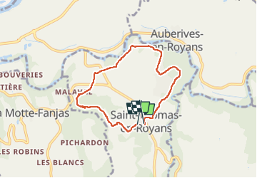
Randonnée Marche de 6,5 km à découvrir à Auvergne-Rhône-Alpes, Drôme, Saint-Thomas-en-Royans. Cette randonnée est proposée par meillon.

Description

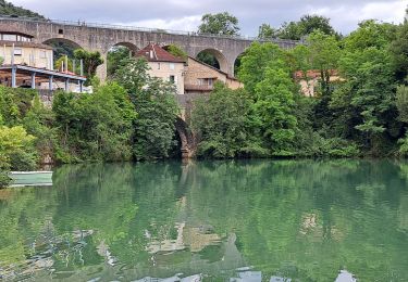
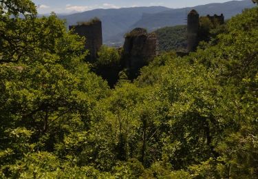
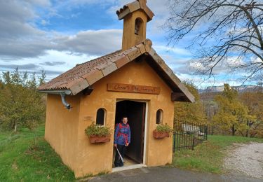
Cheminement autour de Saint Thomas en Royan, montée un peu forte au départ puis agréable ensuite. on aperçoit les contreforts du Vercors, et le noyeraies enfin on longe la Bourne.

Profil altimétrique

Localisation

Pays :
France
Région :
Auvergne-Rhône-Alpes
Département/Province :
Drôme
Commune :
Saint-Thomas-en-Royans
Localité :
Unknown
Départ:(UTM)
680575 ; 4990885 (31T) N.

Randonnées à proximité

Randonnée Marche Saint-Nazaire-en-Royans - Saint Nazaire en Royans - Photo
Marche
GUIDE
nadinebondoux

Marche

Moyen
Saint-Nazaire-en-Royans, Auvergne-Rhône-Alpes, Drôme, France
5,9 km | 10,3 km-effort
2h 32min
Oui
Randonnée Marche Sainte-Eulalie-en-Royans - 26 ste eulalie - Photo
Marche
GUIDE
randodyssée

Marche

Moyen
Sainte-Eulalie-en-Royans, Auvergne-Rhône-Alpes, Drôme, France
14,8 km | 27 km-effort
6h 43min
Non
Randonnée Marche Pont-en-Royans - 38 pont en Royans choranche presles - Photo
Marche
GUIDE
randodyssée

Marche

Difficile
Pont-en-Royans, Auvergne-Rhône-Alpes, Isère, France
15,4 km | 30 km-effort
6h 52min
Oui
Randonnée Marche Saint-Nazaire-en-Royans - 26 rochechinard - Photo
Marche
GUIDE
randodyssée

Marche

Facile
Saint-Nazaire-en-Royans, Auvergne-Rhône-Alpes, Drôme, France
8,3 km | 14,4 km-effort
3h 5min
Non
Randonnée Marche Pont-en-Royans - 38 pont en Royans st andre - Photo
Marche
GUIDE
randodyssée

Marche

Facile
Pont-en-Royans, Auvergne-Rhône-Alpes, Isère, France
14,1 km | 19,3 km-effort
3h 33min
Oui
Randonnée Marche Pont-en-Royans - 38 pont en Royans serre cocu - Photo
Marche
GUIDE
randodyssée

Marche

Moyen
Pont-en-Royans, Auvergne-Rhône-Alpes, Isère, France
16 km | 29 km-effort
7h 44min
Oui
Randonnée sport Saint-Laurent-en-Royans - St Laurent en Royans. La Laurentine - Photo
sport
alinetpierre

sport

Très facile
Saint-Laurent-en-Royans, Auvergne-Rhône-Alpes, Drôme, France
16,3 km | 27 km-effort
Inconnu
Oui
Randonnée Marche Saint-Nazaire-en-Royans - St Nazaire en Royans  - Photo
Marche
alinetpierre

Marche

Difficile
Saint-Nazaire-en-Royans, Auvergne-Rhône-Alpes, Drôme, France
12,3 km | 19 km-effort
2h 49min
Oui
Randonnée Marche nordique Saint-Laurent-en-Royans - Circuit entre Saint-Laurent-en-Royans et Pont-en-Royans - Photo
Marche nordique
Emelle

Marche nordique

Moyen
Saint-Laurent-en-Royans, Auvergne-Rhône-Alpes, Drôme, France
13 km | 17,4 km-effort
5h 9min
Oui


Fermer
Mes abonnements