Randonnée Marche Chaudenay-la-Ville - Chaudenay la ville  - Photo
 eric.guyard21
eric.guyard21

Utilisateur

© OpenStreetMap contributors
Longueur
Longueur
14,1 km
Altitude max
Altitude max
538 m
Dénivelé positif
Dénivelé positif
286 m
Km-Effort
Km-Effort  
17,9 km
Altitude min
Altitude min
325 m
Dénivelé négatif
Dénivelé négatif
284 m
Boucle
Boucle
Oui
Date de création :
2022-10-10 13:24:26.0
Dernière modification :
2022-10-10 16:07:52.221

(0 Avis)

Marche
Marche
2h37
Difficulté : Facile

Scannez ce code QR pour ouvrir la randonnée dans l'application SityTrail

Application GPS de randonnée GRATUITE

Logo SityTrail SityTrail

IGN / Instituts géographiques

Télécharger SityTrail sur l'App Store Télécharger SityTrail sur Google Play

Logo SityTrail SityTrail World

Le monde est à vous

Télécharger SityTrail sur l'App Store Télécharger SityTrail sur Google Play Télécharger SityTrail sur Huawei AppGallery

À propos

Randonnée Marche de 14,1 km à découvrir à Bourgogne-Franche-Comté, Côte-d'Or, Chaudenay-la-Ville. Cette randonnée est proposée par eric.guyard21.

Profil altimétrique

Photos

Localisation

Pays :
France
Région :
Bourgogne-Franche-Comté
Département/Province :
Côte-d'Or
Commune :
Chaudenay-la-Ville
Localité :
Unknown
Départ:(Dec)
Départ:(UTM)
625131 ; 5224829 (31T) N.

Randonnées à proximité

Randonnée A pied Aubaine - De Combe en Combe - Photo
A pied
GUIDE+

A pied

Facile
Aubaine, Bourgogne-Franche-Comté, Côte-d'Or, France
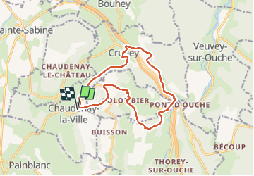
14,5 km | 19,9 km-effort
4h 31min
Oui
Randonnée Cyclotourisme Veuvey-sur-Ouche - 71 Bourgogne J8/8 - Photo
Cyclotourisme
ericf64

Cyclotourisme

Moyen
Veuvey-sur-Ouche, Bourgogne-Franche-Comté, Côte-d'Or, France
57 km | 66 km-effort
7h 0min
Non
Randonnée Marche Colombier - Pont d ouche Pont d ouche par chaudenais la ville Crugey - Photo
Marche
Barbirotin21

Marche

Facile
Colombier, Bourgogne-Franche-Comté, Côte-d'Or, France
13,8 km | 17,7 km-effort
3h 33min
Oui
Randonnée Marche Crugey - le canal de bourgogne Gissey le vieil 3 - Photo
Marche
BrassensJC

Marche

Moyen
Crugey, Bourgogne-Franche-Comté, Côte-d'Or, France
25 km | 27 km-effort
5h 56min
Non
Randonnée Autre activité Thorey-sur-Ouche - ouche - Photo
Autre activité
gilles1955

Autre activité

Très facile
Thorey-sur-Ouche, Bourgogne-Franche-Comté, Côte-d'Or, France
21 km | 23 km-effort
2h 10min
Oui
Randonnée Marche Thorey-sur-Ouche - Bligny - Photo
Marche
jpbus

Marche

Facile
Thorey-sur-Ouche, Bourgogne-Franche-Comté, Côte-d'Or, France
12,2 km | 15,9 km-effort
3h 35min
Non
Randonnée Marche Sainte-Sabine - ste Sabine  - Photo
Marche
Anne Mercuzot

Marche

Très difficile
Sainte-Sabine, Bourgogne-Franche-Comté, Côte-d'Or, France
17,1 km | 21 km-effort
3h 43min
Non
Randonnée Marche Thorey-sur-Ouche - Abc reel thorey - Photo
Marche
jeanyvesjacquetton

Marche

Très difficile
Thorey-sur-Ouche, Bourgogne-Franche-Comté, Côte-d'Or, France
19,3 km | 26 km-effort
5h 55min
Oui
Randonnée Marche Thorey-sur-Ouche - Thorey sur Ouche - Photo
Marche
BTraverse

Marche

Très difficile
Thorey-sur-Ouche, Bourgogne-Franche-Comté, Côte-d'Or, France
19,2 km | 26 km-effort
5h 16min
Oui


Fermer
Mes abonnements