![](/images/other/stat-length.png)
![Randonnée V.T.C. Vif - Vif à Grenoble par le col de l'Eperrimont - Photo](https://media.geolcdn.com/t/1900/400/ext.pjpeg?maxdim=2&url=https%3A%2F%2Fstatic1.geolcdn.com%2Fsiteimages%2Fupload%2Ffiles%2F1524743154velo.jpg)
Vif à Grenoble par le col de l'Eperrimont
CABERMAT
Utilisateur
![Longueur](/images/other/stat-length.png)
![Altitude max](https://static1.geolcdn.com/siteimages/upload/files/1508320355ic_sort_altitude_max_24dp.png)
![Dénivelé positif](https://static1.geolcdn.com/siteimages/upload/files/1508320355ic_sort_den_pos_24dp.png)
![Km-Effort](/images/other/stat-length.png)
![Altitude min](https://static1.geolcdn.com/siteimages/upload/files/1508320355ic_sort_altitude_min_24dp.png)
![Dénivelé négatif](https://static1.geolcdn.com/siteimages/upload/files/1508320355ic_sort_den_neg_24dp.png)
![Boucle](https://static1.geolcdn.com/siteimages/upload/files/16400158638029165_repeat_loop_refresh_sync_direction_icon.png)
![V.T.C.](https://static1.geolcdn.com/sitytour/trail-icons/203.png)
5h00
Difficulté : Difficile
![Vélo électrique](https://static1.geolcdn.com/sitytour/trail-icons/205.png)
5h00
Difficulté : Difficile
![Scannez ce code QR pour ouvrir la randonnée dans l'application SityTrail](https://capi.geolives.com/qq0zvz2zws4bq2lad0pu/sitytour/trails/3414850/qr.png?size=200)
Application GPS de randonnée GRATUITE
À propos
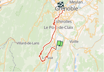
Randonnée V.T.C. de 45 km à découvrir à Auvergne-Rhône-Alpes, Isère, Vif. Cette randonnée est proposée par CABERMAT.
Description
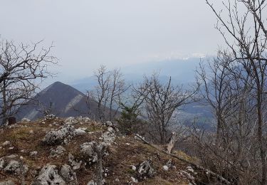
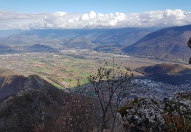
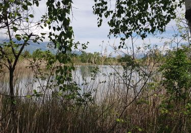
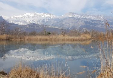
Rando VTC en VAE. Au dessus de Vif montée raide à Le Molard et Champrond. Après les Grands Amieux, chemin agricole jusqu'au Petits Amieux, continuer à monter pour rejoindre la D8 alt 800m (le chemin redevient goudronné sur le dernier km). Traverser Prélenfrey et remonter la route forestière jusqu'au col de L'Eperrimont. Au col continuer tout droit sur le chemin forestier qui descend au bout de 200m en 6 lacets vers les Combes. Ensuite prendre de PR jusqu'à la cote 643m (passages raides qui s'apparentent plus à du VTT). Poursuivre jusqu'au lacet et continuer tout droit (rive droite du ruisseau) jusqu'au Pont Batou. On a fini la partie chemin de terre. Poursuivre tout droit jusqu'à l'autoroute (cote 285), contourner l'étang par la gauche et récupérer la piste cyclable qui longe l'autoroute jusqu'à Claix (cote 251). Partir à gauche le long de la D269, au rond point prendre la 1ère à droite, puis à droite encore jusqu'à Le Coteau et La Balme. Prendre le chemin agricole qui remonte jusqu'à la cote 414 au niveau de la D106d. Juste avant la route prendre le chemin à droite qui amène dans l'épingle à cheveu de la route du Fort de Comboire. Monter jusqu'au Belvédère. Descente par la route du fort, passer la déchetterie et rejoindre la grande route qui passe devant le golf en restant rive droite des ruisseaux (pistes cyclables). Rejoindre Grenoble en prenant la passerelle du Rondeau, puis la piste jusqu'à Mistral .... Beau parcours de 45 km qui mélange petites routes, chemins agricoles et forestiers (12km en tout, de chemins caillouteux dont la moitié en descente).
Localisation
Commentaires
Randonnées à proximité
![Randonnée Marche Champ-sur-Drac - 38 Couvent St Michel Champ / drac - Photo](https://media.geolcdn.com/t/375/260/2541c209-e2b9-4fc5-ac0c-29659bf67ee5.jpg&format=jpg&maxdim=2)
![Marche Marche](https://static1.geolcdn.com/sitytour/trail-icons/101.png)
Marche
![](/images/other/stat-length.png)
![](https://static1.geolcdn.com/siteimages/upload/files/16400158638029165_repeat_loop_refresh_sync_direction_icon.png)
![Randonnée Marche Varces-Allières-et-Risset - Les Etangs de Reymure réaménagés en 2023. - Photo](https://media.geolcdn.com/t/375/260/a9036917-cc32-4324-8d0a-4d872f501612.jpg&format=jpg&maxdim=2)
![Marche Marche](https://static1.geolcdn.com/sitytour/trail-icons/101.png)
Marche
![](/images/other/stat-length.png)
![](https://static1.geolcdn.com/siteimages/upload/files/16400158638029165_repeat_loop_refresh_sync_direction_icon.png)
![Randonnée Marche Vif - la ferme oriol en circuit - Photo](https://media.geolcdn.com/t/375/260/40456475-f1df-45a6-819a-93e9ddb16412.jpg&format=jpg&maxdim=2)
![Marche Marche](https://static1.geolcdn.com/sitytour/trail-icons/101.png)
Marche
![](/images/other/stat-length.png)
![](https://static1.geolcdn.com/siteimages/upload/files/16400158638029165_repeat_loop_refresh_sync_direction_icon.png)
![Randonnée Marche Saint-Georges-de-Commiers - Boucle autour de Saint Georges de Commiers - Photo](https://media.geolcdn.com/t/375/260/0bfddc52-e2d2-4332-a925-7e71f6c56a54.jpg&format=jpg&maxdim=2)
![Marche Marche](https://static1.geolcdn.com/sitytour/trail-icons/101.png)
Marche
![](/images/other/stat-length.png)
![](https://static1.geolcdn.com/siteimages/upload/files/16400158638029165_repeat_loop_refresh_sync_direction_icon.png)
![Randonnée Marche Le Gua - Un tour de L'Eperrimont par le sommet ! - Photo](https://media.geolcdn.com/t/375/260/86c123e6-6997-4f93-970a-703604abf85f.jpg&format=jpg&maxdim=2)
![Marche Marche](https://static1.geolcdn.com/sitytour/trail-icons/101.png)
Marche
![](/images/other/stat-length.png)
![](https://static1.geolcdn.com/siteimages/upload/files/16400158638029165_repeat_loop_refresh_sync_direction_icon.png)
![Randonnée Marche Le Gua - Le Pieu depuis Les Petits Amieux - Photo](https://media.geolcdn.com/t/375/260/bc0f1a32-2a26-4597-a0e3-8997a2b8a6b8.jpg&format=jpg&maxdim=2)
![Marche Marche](https://static1.geolcdn.com/sitytour/trail-icons/101.png)
Marche
![](/images/other/stat-length.png)
![](https://static1.geolcdn.com/siteimages/upload/files/16400158638029165_repeat_loop_refresh_sync_direction_icon.png)
![Randonnée Marche nordique Vif - Les Etangs de la Plaine de Reymure - Photo](https://media.geolcdn.com/t/375/260/1d6be850-f5d4-4e8e-a42b-a881c0492ad2.jpg&format=jpg&maxdim=2)
![Marche nordique Marche nordique](https://static1.geolcdn.com/sitytour/trail-icons/102.png)
Marche nordique
![](/images/other/stat-length.png)
![](https://static1.geolcdn.com/siteimages/upload/files/16400158638029165_repeat_loop_refresh_sync_direction_icon.png)
![Randonnée Marche nordique Varces-Allières-et-Risset - De la plaine de Reymure au canal de Malissolles - Photo](https://media.geolcdn.com/t/375/260/3d91b17d-7f71-4e45-96ae-37747dd4929a.jpg&format=jpg&maxdim=2)
![Marche nordique Marche nordique](https://static1.geolcdn.com/sitytour/trail-icons/102.png)
Marche nordique
![](/images/other/stat-length.png)
![](https://static1.geolcdn.com/siteimages/upload/files/16400158638029165_repeat_loop_refresh_sync_direction_icon.png)
![Randonnée Marche Vif - Circuit entre Vif et les sources de l'Echaillon par la cabane d'Uriol avec retour par Champrond - Photo](https://media.geolcdn.com/t/375/260/064ad078-4d4b-4439-8dbb-d18d7e525498.jpg&format=jpg&maxdim=2)
![Marche Marche](https://static1.geolcdn.com/sitytour/trail-icons/101.png)
Marche
![](/images/other/stat-length.png)
![](https://static1.geolcdn.com/siteimages/upload/files/16400158638029165_repeat_loop_refresh_sync_direction_icon.png)