![](/images/other/stat-length.png)
![Randonnée Marche Sivry-Rance - Promenade du Bois de Bruyère - Photo](https://media.geolcdn.com/t/1900/400/ext.pjpeg?maxdim=2&url=https%3A%2F%2Fstatic1.geolcdn.com%2Fsiteimages%2Fupload%2Ffiles%2F1553511878bg_sport_marche.png)
Promenade du Bois de Bruyère
Mady Lambert
Utilisateur
![Longueur](/images/other/stat-length.png)
Longueur
2,8 km
![Altitude max](https://static1.geolcdn.com/siteimages/upload/files/1508320355ic_sort_altitude_max_24dp.png)
Altitude max
260 m
![Dénivelé positif](https://static1.geolcdn.com/siteimages/upload/files/1508320355ic_sort_den_pos_24dp.png)
Dénivelé positif
36 m
![Km-Effort](/images/other/stat-length.png)
Km-Effort
3,2 km
![Altitude min](https://static1.geolcdn.com/siteimages/upload/files/1508320355ic_sort_altitude_min_24dp.png)
Altitude min
232 m
![Dénivelé négatif](https://static1.geolcdn.com/siteimages/upload/files/1508320355ic_sort_den_neg_24dp.png)
Dénivelé négatif
36 m
![Boucle](https://static1.geolcdn.com/siteimages/upload/files/16400158638029165_repeat_loop_refresh_sync_direction_icon.png)
Boucle
Oui
Date de création :
2022-09-30 13:18:16.604
Dernière modification :
2022-09-30 15:58:25.397
![Marche](https://static1.geolcdn.com/sitytour/trail-icons/101.png)
2h39
Difficulté : Facile
![Scannez ce code QR pour ouvrir la randonnée dans l'application SityTrail](https://capi.geolives.com/qq0zvz2zws4bq2lad0pu/sitytour/trails/3408615/qr.png?size=200)
Application GPS de randonnée GRATUITE
À propos
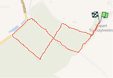
Randonnée Marche de 2,8 km à découvrir à Wallonie, Hainaut, Sivry-Rance. Cette randonnée est proposée par Mady Lambert.
Description
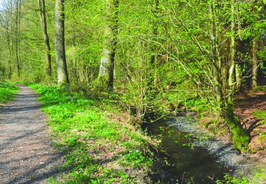
Promenade forestière en boucle.
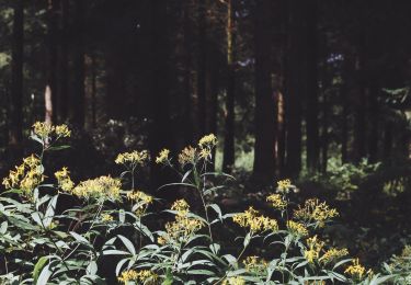
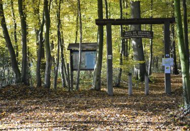
Des panneaux didactiques permettent de découvrir les activités sylvicoles, la faune, la flore et la variété impressionnante d'arbres.
Parking et aire de pique-nique.
Localisation
Pays :
Belgique
Région :
Wallonie
Département/Province :
Hainaut
Commune :
Sivry-Rance
Localité :
Unknown
Départ:(Dec)
Départ:(UTM)
586464 ; 5556611 (31U) N.
Commentaires
Randonnées à proximité
![Randonnée Marche Sivry-Rance - Sivry-Rance (02) - Promenade du Mont Rosé - Photo](https://media.geolcdn.com/t/375/260/ext.jpg?maxdim=2&url=https%3A%2F%2Fservices.sitytrail.com%2FGeolivesWS%2FDownloadMedia.ashx%3FTrailID%3D311157%26Media%3Dca45369c-c4e2-49a8-8627-fc9e05ebc525.JPG)
![Marche Marche](https://static1.geolcdn.com/sitytour/trail-icons/101.png)
Sivry-Rance (02) - Promenade du Mont Rosé
Marche
Moyen
(1)
Sivry-Rance,
Wallonie,
Hainaut,
Belgique
![](/images/other/stat-length.png)
6,7 km | 7,9 km-effort
1h 45min
![](https://static1.geolcdn.com/siteimages/upload/files/16400158638029165_repeat_loop_refresh_sync_direction_icon.png)
Oui
![Randonnée V.T.C. Sivry-Rance - Sivry Gare - Robechies - Rance - Photo](https://media.geolcdn.com/t/375/260/73d602ef-978e-4b6d-980e-4af8ec05b02c.jpg&format=jpg&maxdim=2)
![V.T.C. V.T.C.](https://static1.geolcdn.com/sitytour/trail-icons/203.png)
Sivry Gare - Robechies - Rance
V.T.C.
Très facile
(2)
Sivry-Rance,
Wallonie,
Hainaut,
Belgique
![](/images/other/stat-length.png)
41 km | 48 km-effort
2h 31min
![](https://static1.geolcdn.com/siteimages/upload/files/16400158638029165_repeat_loop_refresh_sync_direction_icon.png)
Oui
![Randonnée Marche Sivry-Rance - Sivry-Rance (06) - Sivry - Promenade du Grand Thumas - Photo](https://media.geolcdn.com/t/375/260/ext.jpg?maxdim=2&url=https%3A%2F%2Fservices.sitytrail.com%2FGeolivesWS%2FDownloadMedia.ashx%3FTrailID%3D311164%26Media%3D8cc43fbe-f875-4530-a462-14a28c742760.JPG)
![Marche Marche](https://static1.geolcdn.com/sitytour/trail-icons/101.png)
Sivry-Rance (06) - Sivry - Promenade du Grand Thumas
Marche
Très facile
(5)
Sivry-Rance,
Wallonie,
Hainaut,
Belgique
![](/images/other/stat-length.png)
5,5 km | 6,5 km-effort
1h 30min
![](https://static1.geolcdn.com/siteimages/upload/files/16400158638029165_repeat_loop_refresh_sync_direction_icon.png)
Oui
![Randonnée Marche Sivry-Rance - Sivry-Rance (13) - Promenade de la Vallée de l'Eau d'Eppe - Photo](https://media.geolcdn.com/t/375/260/ext.jpg?maxdim=2&url=https%3A%2F%2Fservices.sitytrail.com%2FGeolivesWS%2FDownloadMedia.ashx%3FTrailID%3D311163%26Media%3Db7af1830-b06f-43cc-9ab9-a464f12aaa86.JPG)
![Marche Marche](https://static1.geolcdn.com/sitytour/trail-icons/101.png)
Sivry-Rance (13) - Promenade de la Vallée de l'Eau d'Eppe
Marche
Très facile
(2)
Sivry-Rance,
Wallonie,
Hainaut,
Belgique
![](/images/other/stat-length.png)
6,6 km | 8,4 km-effort
2h 0min
![](https://static1.geolcdn.com/siteimages/upload/files/16400158638029165_repeat_loop_refresh_sync_direction_icon.png)
Oui
![Randonnée Marche Sivry-Rance - De Sautin vers Montbliart par la vallee de l'Eau d'Eppe - Photo](https://media.geolcdn.com/t/375/260/ext.jpg?maxdim=2&url=https%3A%2F%2Fstatic1.geolcdn.com%2Fsiteimages%2Fupload%2Ffiles%2F1553511878bg_sport_marche.png)
![Marche Marche](https://static1.geolcdn.com/sitytour/trail-icons/101.png)
De Sautin vers Montbliart par la vallee de l'Eau d'Eppe
Marche
Moyen
(1)
Sivry-Rance,
Wallonie,
Hainaut,
Belgique
![](/images/other/stat-length.png)
17,3 km | 21 km-effort
4h 20min
![](https://static1.geolcdn.com/siteimages/upload/files/16400158638029165_repeat_loop_refresh_sync_direction_icon.png)
Oui
![Randonnée A pied Sivry-Rance - Promenade du Ry d'Hernoy - Photo](https://media.geolcdn.com/t/375/260/3576f0ab-5152-4ef1-90e0-3b37b935b6bd.jpeg&format=jpg&maxdim=2)
![A pied A pied](https://static1.geolcdn.com/sitytour/trail-icons/100.png)
Promenade du Ry d'Hernoy
A pied
Facile
Sivry-Rance,
Wallonie,
Hainaut,
Belgique
![](/images/other/stat-length.png)
9,8 km | 11,8 km-effort
2h 41min
![](https://static1.geolcdn.com/siteimages/upload/files/16400158638029165_repeat_loop_refresh_sync_direction_icon.png)
Oui
![Randonnée A pied Sivry-Rance - Promenade du Ry d'Hernoy - Photo](https://media.geolcdn.com/t/375/260/ext.jpg?maxdim=2&url=https%3A%2F%2Fpivotmedia.tourismewallonie.be%2FOTH-A0-004C-34MC%2FOTH-A0-004C-34MC.jpg)
![A pied A pied](https://static1.geolcdn.com/sitytour/trail-icons/100.png)
Promenade du Ry d'Hernoy
A pied
Facile
(1)
Sivry-Rance,
Wallonie,
Hainaut,
Belgique
![](/images/other/stat-length.png)
9,7 km | 11,6 km-effort
2h 38min
![](https://static1.geolcdn.com/siteimages/upload/files/16400158638029165_repeat_loop_refresh_sync_direction_icon.png)
Oui
![Randonnée A pied Sivry-Rance - Promenade du Ry de Fromont - Photo](https://media.geolcdn.com/t/375/260/ext.jpg?maxdim=2&url=https%3A%2F%2Fpivotmedia.tourismewallonie.be%2FOTH-A0-004G-2A51%2FOTH-A0-004G-2A51.jpg)
![A pied A pied](https://static1.geolcdn.com/sitytour/trail-icons/100.png)
Promenade du Ry de Fromont
A pied
Facile
Sivry-Rance,
Wallonie,
Hainaut,
Belgique
![](/images/other/stat-length.png)
3,7 km | 4,6 km-effort
1h 3min
![](https://static1.geolcdn.com/siteimages/upload/files/16400158638029165_repeat_loop_refresh_sync_direction_icon.png)
Oui
![Randonnée A pied Sivry-Rance - Promenade de la Pierre qui Tourne - Photo](https://media.geolcdn.com/t/375/260/ext.jpg?maxdim=2&url=https%3A%2F%2Fpivotmedia.tourismewallonie.be%2FOTH-A0-004G-29NM%2FOTH-A0-004G-29NM.jpg)
![A pied A pied](https://static1.geolcdn.com/sitytour/trail-icons/100.png)
Promenade de la Pierre qui Tourne
A pied
Facile
Sivry-Rance,
Wallonie,
Hainaut,
Belgique
![](/images/other/stat-length.png)
7,4 km | 8,8 km-effort
1h 59min
![](https://static1.geolcdn.com/siteimages/upload/files/16400158638029165_repeat_loop_refresh_sync_direction_icon.png)
Oui