![](/images/other/stat-length.png)
![Randonnée Marche Loire-sur-Rhône - 69-loire-sur-rhone2-pet-de-loup-18km-560m - Photo](https://media.geolcdn.com/t/1900/400/ee6f14b8-8ed9-4a30-84a4-6a7d5babc72f.jpg&format=pjpeg&maxdim=2)
69-loire-sur-rhone2-pet-de-loup-18km-560m
SyMA
Utilisateur
![Longueur](/images/other/stat-length.png)
Longueur
17,7 km
![Altitude max](https://static1.geolcdn.com/siteimages/upload/files/1508320355ic_sort_altitude_max_24dp.png)
Altitude max
560 m
![Dénivelé positif](https://static1.geolcdn.com/siteimages/upload/files/1508320355ic_sort_den_pos_24dp.png)
Dénivelé positif
556 m
![Km-Effort](/images/other/stat-length.png)
Km-Effort
25 km
![Altitude min](https://static1.geolcdn.com/siteimages/upload/files/1508320355ic_sort_altitude_min_24dp.png)
Altitude min
330 m
![Dénivelé négatif](https://static1.geolcdn.com/siteimages/upload/files/1508320355ic_sort_den_neg_24dp.png)
Dénivelé négatif
558 m
![Boucle](https://static1.geolcdn.com/siteimages/upload/files/16400158638029165_repeat_loop_refresh_sync_direction_icon.png)
Boucle
Oui
Date de création :
2022-09-26 06:54:15.862
Dernière modification :
2022-09-26 16:03:22.998
![Marche](https://static1.geolcdn.com/sitytour/trail-icons/101.png)
3h03
Difficulté : Moyen
![Scannez ce code QR pour ouvrir la randonnée dans l'application SityTrail](https://capi.geolives.com/qq0zvz2zws4bq2lad0pu/sitytour/trails/3404200/qr.png?size=200)
Application GPS de randonnée GRATUITE
À propos
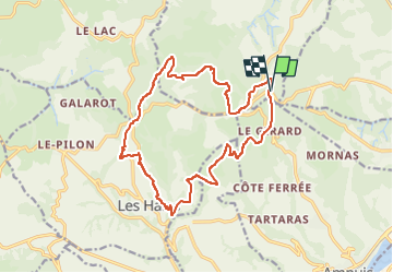
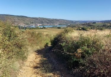
Randonnée Marche de 17,7 km à découvrir à Auvergne-Rhône-Alpes, Rhône, Loire-sur-Rhône. Cette randonnée est proposée par SyMA.
Description
petit parking le long de D502
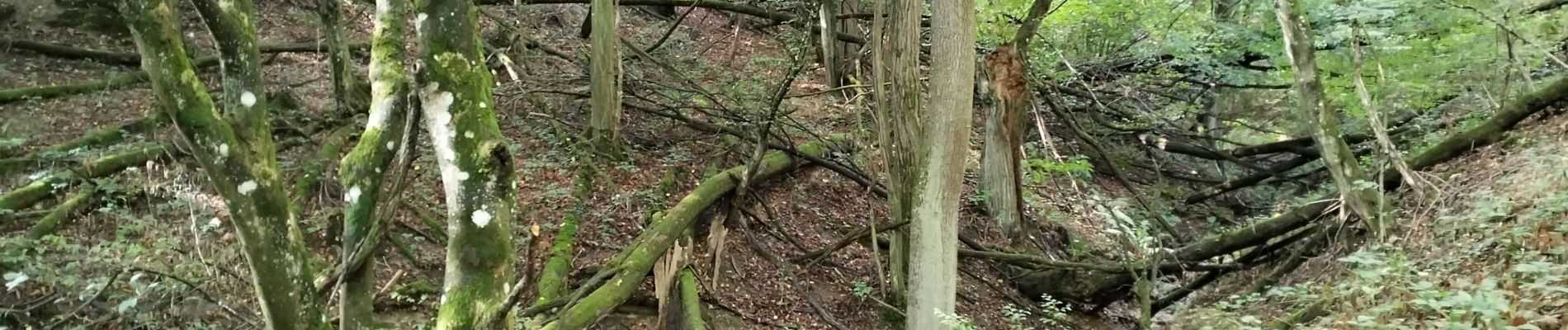
Belle rando mélangeant montées /descentes
Panoramas
Difficile à faire en VTT car beaucoup de chemins creusés.
pique-nique possible Croix Regis (10km) ou avant à la Vierge (9.5km)
Localisation
Pays :
France
Région :
Auvergne-Rhône-Alpes
Département/Province :
Rhône
Commune :
Loire-sur-Rhône
Localité :
Unknown
Départ:(Dec)
Départ:(UTM)
639528 ; 5043281 (31T) N.
Commentaires
Randonnées à proximité
![Randonnée Marche Loire-sur-Rhône - 42 le grisard (vienne) - Photo](https://media.geolcdn.com/t/375/260/c8c552c2-c833-47f9-98c4-fadea207952f.jpg&format=jpg&maxdim=2)
![Marche Marche](https://static1.geolcdn.com/sitytour/trail-icons/101.png)
42 le grisard (vienne)
Marche
Très facile
Loire-sur-Rhône,
Auvergne-Rhône-Alpes,
Rhône,
France
![](/images/other/stat-length.png)
5,6 km | 8,2 km-effort
2h 8min
![](https://static1.geolcdn.com/siteimages/upload/files/16400158638029165_repeat_loop_refresh_sync_direction_icon.png)
Oui
![Randonnée Marche Saint-Romain-en-Gal - le grisard - Photo](https://media.geolcdn.com/t/375/260/ext.jpg?maxdim=2&url=https%3A%2F%2Fstatic1.geolcdn.com%2Fsiteimages%2Fupload%2Ffiles%2F1553511878bg_sport_marche.png)
![Marche Marche](https://static1.geolcdn.com/sitytour/trail-icons/101.png)
le grisard
Marche
Moyen
(1)
Saint-Romain-en-Gal,
Auvergne-Rhône-Alpes,
Rhône,
France
![](/images/other/stat-length.png)
5,3 km | 7,9 km-effort
1h 48min
![](https://static1.geolcdn.com/siteimages/upload/files/16400158638029165_repeat_loop_refresh_sync_direction_icon.png)
Oui
![Randonnée Marche Loire-sur-Rhône - 69-Loire-sur-Rhone-17km-480m-avr22 - Photo](https://media.geolcdn.com/t/375/260/13a86102-41dd-4011-b432-58d1cdb1bc2f.jpg&format=jpg&maxdim=2)
![Marche Marche](https://static1.geolcdn.com/sitytour/trail-icons/101.png)
69-Loire-sur-Rhone-17km-480m-avr22
Marche
Moyen
Loire-sur-Rhône,
Auvergne-Rhône-Alpes,
Rhône,
France
![](/images/other/stat-length.png)
16,7 km | 23 km-effort
5h 9min
![](https://static1.geolcdn.com/siteimages/upload/files/16400158638029165_repeat_loop_refresh_sync_direction_icon.png)
Oui
![Randonnée A pied La Chapelle-Villars - Pilat N°30: des «Côteaux à les Haies» - Photo](https://media.geolcdn.com/t/375/260/dcae721c-56d2-4080-8395-c9b2db29b909.jpeg&format=jpg&maxdim=2)
![A pied A pied](https://static1.geolcdn.com/sitytour/trail-icons/100.png)
Pilat N°30: des «Côteaux à les Haies»
A pied
Difficile
La Chapelle-Villars,
Auvergne-Rhône-Alpes,
Loire,
France
![](/images/other/stat-length.png)
29 km | 37 km-effort
8h 27min
![](https://static1.geolcdn.com/siteimages/upload/files/16400158638029165_repeat_loop_refresh_sync_direction_icon.png)
Oui
![Randonnée Marche Ampuis - AMPUIS JC - Photo](https://media.geolcdn.com/t/375/260/ext.jpg?maxdim=2&url=https%3A%2F%2Fstatic1.geolcdn.com%2Fsiteimages%2Fupload%2Ffiles%2F1553511878bg_sport_marche.png)
![Marche Marche](https://static1.geolcdn.com/sitytour/trail-icons/101.png)
AMPUIS JC
Marche
Très facile
(1)
Ampuis,
Auvergne-Rhône-Alpes,
Rhône,
France
![](/images/other/stat-length.png)
9,7 km | 12,1 km-effort
3h 10min
![](https://static1.geolcdn.com/siteimages/upload/files/16400158638029165_repeat_loop_refresh_sync_direction_icon.png)
Oui
![Randonnée V.T.T. Reventin-Vaugris - Écureuil 2013 - Photo](https://media.geolcdn.com/t/375/260/ext.jpg?maxdim=2&url=https%3A%2F%2Fstatic1.geolcdn.com%2Fsiteimages%2Fupload%2Ffiles%2F1524743154velo.jpg)
![V.T.T. V.T.T.](https://static1.geolcdn.com/sitytour/trail-icons/202.png)
Écureuil 2013
V.T.T.
Difficile
(1)
Reventin-Vaugris,
Auvergne-Rhône-Alpes,
Isère,
France
![](/images/other/stat-length.png)
30 km | 40 km-effort
2h 34min
![](https://static1.geolcdn.com/siteimages/upload/files/16400158638029165_repeat_loop_refresh_sync_direction_icon.png)
Oui
![Randonnée Marche Loire-sur-Rhône - St romain x - Photo](https://media.geolcdn.com/t/375/260/358b915a-eb20-4dde-b906-3f49a51f6028.jpg&format=jpg&maxdim=2)
![Marche Marche](https://static1.geolcdn.com/sitytour/trail-icons/101.png)
St romain x
Marche
Loire-sur-Rhône,
Auvergne-Rhône-Alpes,
Rhône,
France
![](/images/other/stat-length.png)
3,6 km | 5 km-effort
1h 57min
![](https://static1.geolcdn.com/siteimages/upload/files/16400158638029165_repeat_loop_refresh_sync_direction_icon.png)
Non
![Randonnée Marche Reventin-Vaugris - Reventin - Photo](https://media.geolcdn.com/t/375/260/c3806f76-b895-481e-a817-a286e184dd44.jpg&format=jpg&maxdim=2)
![Marche Marche](https://static1.geolcdn.com/sitytour/trail-icons/101.png)
Reventin
Marche
Très facile
Reventin-Vaugris,
Auvergne-Rhône-Alpes,
Isère,
France
![](/images/other/stat-length.png)
2,7 km | 4,1 km-effort
45min
![](https://static1.geolcdn.com/siteimages/upload/files/16400158638029165_repeat_loop_refresh_sync_direction_icon.png)
Oui
![Randonnée Marche Échalas - cx régis reco 01 08 23 - 8km a 218 g0.5 - Photo](https://media.geolcdn.com/t/375/260/ext.jpg?maxdim=2&url=https%3A%2F%2Fstatic1.geolcdn.com%2Fsiteimages%2Fupload%2Ffiles%2F1553511878bg_sport_marche.png)
![Marche Marche](https://static1.geolcdn.com/sitytour/trail-icons/101.png)
cx régis reco 01 08 23 - 8km a 218 g0.5
Marche
Moyen
Échalas,
Auvergne-Rhône-Alpes,
Rhône,
France
![](/images/other/stat-length.png)
7,9 km | 10,8 km-effort
2h 43min
![](https://static1.geolcdn.com/siteimages/upload/files/16400158638029165_repeat_loop_refresh_sync_direction_icon.png)
Oui