![](/images/other/stat-length.png)
![Randonnée Marche Diekirch - Eislek pad Diekirch - Photo](https://media.geolcdn.com/t/1900/400/ext.pjpeg?maxdim=2&url=https%3A%2F%2Fstatic1.geolcdn.com%2Fsiteimages%2Fupload%2Ffiles%2F1553511878bg_sport_marche.png)
Eislek pad Diekirch
mumu.larandonneuse
Utilisateur GUIDE
![Longueur](/images/other/stat-length.png)
![Altitude max](https://static1.geolcdn.com/siteimages/upload/files/1508320355ic_sort_altitude_max_24dp.png)
![Dénivelé positif](https://static1.geolcdn.com/siteimages/upload/files/1508320355ic_sort_den_pos_24dp.png)
![Km-Effort](/images/other/stat-length.png)
![Altitude min](https://static1.geolcdn.com/siteimages/upload/files/1508320355ic_sort_altitude_min_24dp.png)
![Dénivelé négatif](https://static1.geolcdn.com/siteimages/upload/files/1508320355ic_sort_den_neg_24dp.png)
![Boucle](https://static1.geolcdn.com/siteimages/upload/files/16400158638029165_repeat_loop_refresh_sync_direction_icon.png)
![Marche](https://static1.geolcdn.com/sitytour/trail-icons/101.png)
4h32
Difficulté : Moyen
![Scannez ce code QR pour ouvrir la randonnée dans l'application SityTrail](https://capi.geolives.com/qq0zvz2zws4bq2lad0pu/sitytour/trails/3399917/qr.png?size=200)
Application GPS de randonnée GRATUITE
À propos
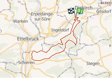
Randonnée Marche de 14,5 km à découvrir à Inconnu, Canton Diekirch, Diekirch. Cette randonnée est proposée par mumu.larandonneuse.
Description
Éislek Pad Diekirch
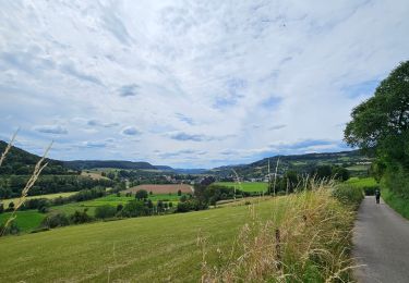
Proche de la grande ville
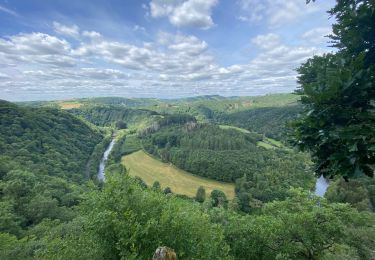
De l'air frais, de vues imprenables et des coins cachés vous attendent au-dessus de la Nordstad. De temps en temps, vous saisissez des vues sur la Nordstad d’en haut. Le Deiwelselter, en français « autel du diable », forme un contraste avec la ville. Ce monument a été construit à partir des pierres d'une tombe préhistorique.
Départ : Chemin de campagne au bout de la rue, In Bedigen, Diekirch
Arrivée : Chemin de campagne au bout de la rue, In Bedigen, Diekirch
Distance : 14,506 km
Altitude : 357 m
Temps : 04h15
ℹ prise sur www.visit-eislek.lu
Localisation
Commentaires
Randonnées à proximité
![Randonnée Marche Bettendorf - Éislek pad Bettendorf - Photo](https://media.geolcdn.com/t/375/260/ba8011a2-7a43-4fed-95b2-07279fc87c67.jpg&format=jpg&maxdim=2)
![Marche Marche](https://static1.geolcdn.com/sitytour/trail-icons/101.png)
Marche
![](/images/other/stat-length.png)
![](https://static1.geolcdn.com/siteimages/upload/files/16400158638029165_repeat_loop_refresh_sync_direction_icon.png)
![Randonnée Marche Ettelbruck - Ettelbruck-Diekirch-Ettelbruck - Photo](https://media.geolcdn.com/t/375/260/ext.jpg?maxdim=2&url=https%3A%2F%2Fservices.sitytrail.com%2FGeolivesWS%2FDownloadMedia.ashx%3FTrailID%3D166967%26Media%3D20121223140113.jpg)
![Marche Marche](https://static1.geolcdn.com/sitytour/trail-icons/101.png)
Marche
![](/images/other/stat-length.png)
![](https://static1.geolcdn.com/siteimages/upload/files/16400158638029165_repeat_loop_refresh_sync_direction_icon.png)
![Randonnée A pied Ettelbruck - Autopédestre Ettelbruck 2 - Photo](https://media.geolcdn.com/t/375/260/13589d77-7558-4ebe-a82c-f89de47c0171.jpeg&format=jpg&maxdim=2)
![A pied A pied](https://static1.geolcdn.com/sitytour/trail-icons/100.png)
A pied
![](/images/other/stat-length.png)
![](https://static1.geolcdn.com/siteimages/upload/files/16400158638029165_repeat_loop_refresh_sync_direction_icon.png)
![Randonnée V.T.T. Erpeldange-sur-Sûre - Pistes_VTT : Erpeldange VTT/MTB - Photo](https://media.geolcdn.com/t/375/260/ext.jpg?maxdim=2&url=https%3A%2F%2Fstatic1.geolcdn.com%2Fsiteimages%2Fupload%2Ffiles%2F1524743154velo.jpg)
![V.T.T. V.T.T.](https://static1.geolcdn.com/sitytour/trail-icons/202.png)
V.T.T.
![](/images/other/stat-length.png)
![](https://static1.geolcdn.com/siteimages/upload/files/16400158638029165_repeat_loop_refresh_sync_direction_icon.png)
![Randonnée Marche Ettelbruck - Escapardenne Lee Trail: Ettelbrück - Moulin de Bourscheid - Photo](https://media.geolcdn.com/t/375/260/328e85aa-d54e-4d22-b642-d0ff495693d6.jpeg&format=jpg&maxdim=2)
![Marche Marche](https://static1.geolcdn.com/sitytour/trail-icons/101.png)
Marche
![](/images/other/stat-length.png)
![](https://static1.geolcdn.com/siteimages/upload/files/16400158638029165_repeat_loop_refresh_sync_direction_icon.png)
![Randonnée A pied Vallée de l'Ernz - E8 - Ermsdorf - Photo](https://media.geolcdn.com/t/375/260/9336dd99-d4f0-4297-b7d8-0ea88499f8cf.jpeg&format=jpg&maxdim=2)
![A pied A pied](https://static1.geolcdn.com/sitytour/trail-icons/100.png)
A pied
![](/images/other/stat-length.png)
![](https://static1.geolcdn.com/siteimages/upload/files/16400158638029165_repeat_loop_refresh_sync_direction_icon.png)
![Randonnée A pied Bettendorf - Autopedestre Bettendorf 1 - Photo](https://media.geolcdn.com/t/375/260/5bdef823-bcca-4fa6-9dc3-423e56c1d982.jpeg&format=jpg&maxdim=2)
![A pied A pied](https://static1.geolcdn.com/sitytour/trail-icons/100.png)
A pied
![](/images/other/stat-length.png)
![](https://static1.geolcdn.com/siteimages/upload/files/16400158638029165_repeat_loop_refresh_sync_direction_icon.png)
![Randonnée A pied Vallée de l'Ernz - E9 - Ermsdorf - Photo](https://media.geolcdn.com/t/375/260/8efc1dd5-e614-476d-aa92-f3bc336e6fc1.jpeg&format=jpg&maxdim=2)
![A pied A pied](https://static1.geolcdn.com/sitytour/trail-icons/100.png)
A pied
![](/images/other/stat-length.png)
![](https://static1.geolcdn.com/siteimages/upload/files/16400158638029165_repeat_loop_refresh_sync_direction_icon.png)
![Randonnée A pied Ettelbruck - Ettelbruck Sentier F - Photo](https://media.geolcdn.com/t/375/260/58772a8e-7513-45e2-b1bb-76f1b6c3969e.jpeg&format=jpg&maxdim=2)
![A pied A pied](https://static1.geolcdn.com/sitytour/trail-icons/100.png)
A pied
![](/images/other/stat-length.png)
![](https://static1.geolcdn.com/siteimages/upload/files/16400158638029165_repeat_loop_refresh_sync_direction_icon.png)