![](/images/other/stat-length.png)
![Randonnée Marche Saint-Julien-de-Jonzy - St-Julien-de-Jonzy : en forêt - Photo](https://media.geolcdn.com/t/1900/400/459c67c8-31f2-431a-a206-3c515d85be94.jpg&format=pjpeg&maxdim=2)
St-Julien-de-Jonzy : en forêt
Jgar
Utilisateur
![Longueur](/images/other/stat-length.png)
![Altitude max](https://static1.geolcdn.com/siteimages/upload/files/1508320355ic_sort_altitude_max_24dp.png)
![Dénivelé positif](https://static1.geolcdn.com/siteimages/upload/files/1508320355ic_sort_den_pos_24dp.png)
![Km-Effort](/images/other/stat-length.png)
![Altitude min](https://static1.geolcdn.com/siteimages/upload/files/1508320355ic_sort_altitude_min_24dp.png)
![Dénivelé négatif](https://static1.geolcdn.com/siteimages/upload/files/1508320355ic_sort_den_neg_24dp.png)
![Boucle](https://static1.geolcdn.com/siteimages/upload/files/16400158638029165_repeat_loop_refresh_sync_direction_icon.png)
![Marche](https://static1.geolcdn.com/sitytour/trail-icons/101.png)
6h07
Difficulté : Moyen
![Scannez ce code QR pour ouvrir la randonnée dans l'application SityTrail](https://capi.geolives.com/qq0zvz2zws4bq2lad0pu/sitytour/trails/3399109/qr.png?size=200)
Application GPS de randonnée GRATUITE
À propos
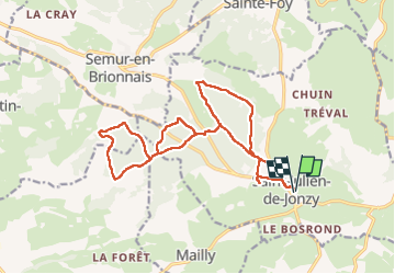
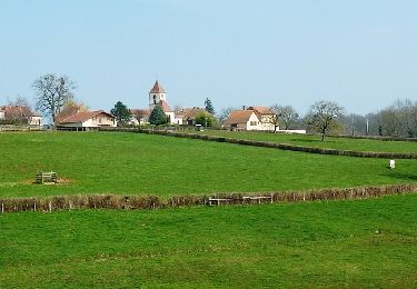
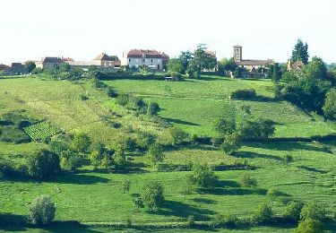
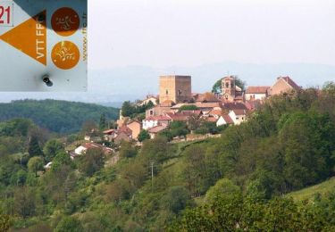
Randonnée Marche de 18,2 km à découvrir à Bourgogne-Franche-Comté, Saône-et-Loire, Saint-Julien-de-Jonzy. Cette randonnée est proposée par Jgar.
Description
Ce circuit forestier est à suivre de préférence par temps chaud. Parking des randonneurs : en venant d'Iguerande, à l'entrée du village à droite.
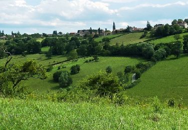
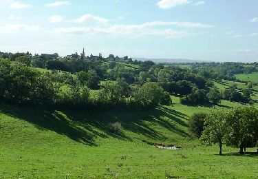
Cet ensemble sylvestre d'environ 500 ha est constitué par divers bois privés, dans la partie nord-occidentale de St-Julien-de-Jonzy.
Se rendre devant l'église romane St Julien, rejoindre la Grande Rue et aller à droite, tout droit sur 800 m. Tourner à gauche en direction de la croix St Jean pour rentrer en forêt.
Se diriger successivement vers les bois Rompay, de la Tour et du Viraud. Descendre à droite pour remonter vers la départementale 9 que vous traverserez pour atteindre le bois Courbe, celui des Prêtres, le bois Morvent et celui du Roi.
Longer ce dernier jusqu'à la cote 420 puis 454. Reprendre une partie de l'aller et tourner à droite du bois du Viraud pour regagner la croix St Jean.
Tourner à droite et atteindre la chapelle du château. Vous reviendrez sur votre chemin pour emprunter la D 8 qui vous ramènera au parking en repassant par l'église..
Localisation
Commentaires
Randonnées à proximité
![Randonnée Marche Saint-Julien-de-Jonzy - St Julien de Jonzy - Photo](https://media.geolcdn.com/t/375/260/ec21bdeb-2fd7-432d-a4a0-e9b652dc5d0a.jpg&format=jpg&maxdim=2)
![Marche Marche](https://static1.geolcdn.com/sitytour/trail-icons/101.png)
Marche
![](/images/other/stat-length.png)
![](https://static1.geolcdn.com/siteimages/upload/files/16400158638029165_repeat_loop_refresh_sync_direction_icon.png)
![Randonnée Moteur Saint-Bonnet-de-Cray - ENDURO BRIONNAIS - Photo](https://media.geolcdn.com/t/375/260/ext.jpg?maxdim=2&url=https%3A%2F%2Fstatic1.geolcdn.com%2Fsiteimages%2Fupload%2Ffiles%2F15247431544x4.jpg)
![Moteur Moteur](https://static1.geolcdn.com/sitytour/trail-icons/400.png)
Moteur
![](/images/other/stat-length.png)
![](https://static1.geolcdn.com/siteimages/upload/files/16400158638029165_repeat_loop_refresh_sync_direction_icon.png)
![Randonnée V.T.T. Saint-Julien-de-Jonzy - VTT sauvage en Brionnais - Saint-Julien-de-Jonzy - Photo](https://media.geolcdn.com/t/375/260/ext.jpg?maxdim=2&url=https%3A%2F%2Fservices.sitytrail.com%2FGeolivesWS%2FDownloadMedia.ashx%3FTrailID%3D215080%26Media%3D15655_1.jpg)
![V.T.T. V.T.T.](https://static1.geolcdn.com/sitytour/trail-icons/202.png)
V.T.T.
![](/images/other/stat-length.png)
![](https://static1.geolcdn.com/siteimages/upload/files/16400158638029165_repeat_loop_refresh_sync_direction_icon.png)
![Randonnée V.T.T. Ligny-en-Brionnais - Balade Lignerotte (2013-VTT-21 km) - Ligny en Brionnais - Photo](https://media.geolcdn.com/t/375/260/ext.jpg?maxdim=2&url=https%3A%2F%2Fservices.sitytrail.com%2FGeolivesWS%2FDownloadMedia.ashx%3FTrailID%3D191572%26Media%3D15193_6.jpg)
![V.T.T. V.T.T.](https://static1.geolcdn.com/sitytour/trail-icons/202.png)
V.T.T.
![](/images/other/stat-length.png)
![](https://static1.geolcdn.com/siteimages/upload/files/16400158638029165_repeat_loop_refresh_sync_direction_icon.png)
![Randonnée V.T.T. Fleury-la-Montagne - Rando VTT à Fleury la Montagne - Photo](https://media.geolcdn.com/t/375/260/ext.jpg?maxdim=2&url=https%3A%2F%2Fservices.sitytrail.com%2FGeolivesWS%2FDownloadMedia.ashx%3FTrailID%3D172448%26Media%3D13803_6.jpg)
![V.T.T. V.T.T.](https://static1.geolcdn.com/sitytour/trail-icons/202.png)
V.T.T.
![](/images/other/stat-length.png)
![](https://static1.geolcdn.com/siteimages/upload/files/16400158638029165_repeat_loop_refresh_sync_direction_icon.png)
![Randonnée V.T.T. Mailly - Centre VTT FFC en Brionnais - Mailly - Parcours N°16 - Photo](https://media.geolcdn.com/t/375/260/ext.jpg?maxdim=2&url=https%3A%2F%2Fservices.sitytrail.com%2FGeolivesWS%2FDownloadMedia.ashx%3FTrailID%3D107063%26Media%3D11882_6.jpg)
![V.T.T. V.T.T.](https://static1.geolcdn.com/sitytour/trail-icons/202.png)
V.T.T.
![](/images/other/stat-length.png)
![](https://static1.geolcdn.com/siteimages/upload/files/16400158638029165_repeat_loop_refresh_sync_direction_icon.png)
![Randonnée V.T.T. Fleury-la-Montagne - Centre VTT FFC en Brionnais - Fleury la Montagne - Parcours N°15 - Photo](https://media.geolcdn.com/t/375/260/ext.jpg?maxdim=2&url=https%3A%2F%2Fservices.sitytrail.com%2FGeolivesWS%2FDownloadMedia.ashx%3FTrailID%3D107062%26Media%3D11881_6.jpg)
![V.T.T. V.T.T.](https://static1.geolcdn.com/sitytour/trail-icons/202.png)
V.T.T.
![](/images/other/stat-length.png)
![](https://static1.geolcdn.com/siteimages/upload/files/16400158638029165_repeat_loop_refresh_sync_direction_icon.png)
![Randonnée V.T.T. Semur-en-Brionnais - VTT en Brionnais - Semur en Bronnais - Parcours N°21 - Photo](https://media.geolcdn.com/t/375/260/ext.jpg?maxdim=2&url=https%3A%2F%2Fservices.sitytrail.com%2FGeolivesWS%2FDownloadMedia.ashx%3FTrailID%3D106300%26Media%3D10683_6.jpg)
![V.T.T. V.T.T.](https://static1.geolcdn.com/sitytour/trail-icons/202.png)
V.T.T.
![](/images/other/stat-length.png)
![](https://static1.geolcdn.com/siteimages/upload/files/16400158638029165_repeat_loop_refresh_sync_direction_icon.png)
![Randonnée Vélo Iguerande - de Iguérande à Decize - Photo](https://media.geolcdn.com/t/375/260/ext.jpg?maxdim=2&url=https%3A%2F%2Fservices.sitytrail.com%2FGeolivesWS%2FDownloadMedia.ashx%3FTrailID%3D583660%26Media%3Dfix__20160606161122.jpg)
![Vélo Vélo](https://static1.geolcdn.com/sitytour/trail-icons/200.png)
Vélo
![](/images/other/stat-length.png)
![](https://static1.geolcdn.com/siteimages/upload/files/16400158638029165_repeat_loop_refresh_sync_direction_icon.png)