![](/images/other/stat-length.png)
![Randonnée V.T.T. Mornas - MORNAS - LA FORTERESSE MONDRAGON - 22km - Photo](https://media.geolcdn.com/t/1900/400/ext.pjpeg?maxdim=2&url=https%3A%2F%2Fstatic1.geolcdn.com%2Fsiteimages%2Fupload%2Ffiles%2F1524743154velo.jpg)
MORNAS - LA FORTERESSE MONDRAGON - 22km
lespoulpes
Utilisateur
![Longueur](/images/other/stat-length.png)
![Altitude max](https://static1.geolcdn.com/siteimages/upload/files/1508320355ic_sort_altitude_max_24dp.png)
![Dénivelé positif](https://static1.geolcdn.com/siteimages/upload/files/1508320355ic_sort_den_pos_24dp.png)
![Km-Effort](/images/other/stat-length.png)
![Altitude min](https://static1.geolcdn.com/siteimages/upload/files/1508320355ic_sort_altitude_min_24dp.png)
![Dénivelé négatif](https://static1.geolcdn.com/siteimages/upload/files/1508320355ic_sort_den_neg_24dp.png)
![Boucle](https://static1.geolcdn.com/siteimages/upload/files/16400158638029165_repeat_loop_refresh_sync_direction_icon.png)
![V.T.T.](https://static1.geolcdn.com/sitytour/trail-icons/202.png)
1h59
Difficulté : Moyen
![Scannez ce code QR pour ouvrir la randonnée dans l'application SityTrail](https://capi.geolives.com/qq0zvz2zws4bq2lad0pu/sitytour/trails/3392627/qr.png?size=200)
Application GPS de randonnée GRATUITE
À propos
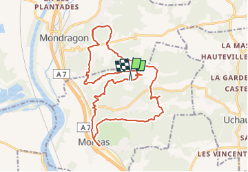
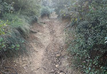
Randonnée V.T.T. de 22 km à découvrir à Provence-Alpes-Côte d'Azur, Vaucluse, Mornas. Cette randonnée est proposée par lespoulpes.
Description
Source Randogps.net
A l'origine randonnée à faire à pieds.
Attention : Le départ indiqué sur la trace est différent car situé plus au nord mais Mornas est un point de départ plus approprié.
A Mornas, vous commencez par monter jusqu'à l'ancienne forteresse puis le GRP du massif d'Uchaux.
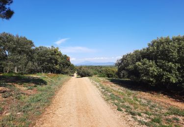
Vous quittez le GRP par le nord jusqu'à rejoindre le GR4 que vous suivez jusqu'à Mondragon.
Le retour à Mornas se fait en récupérant le GRP du massif d'Uchaux qui vous
ramène à votre point de départ.
Randonnée en boucle à faire sur une grosse journée de marche.
Bonne randonnée
Localisation
Commentaires
Randonnées à proximité
![Randonnée Marche Mondragon - mondragon - Photo](https://media.geolcdn.com/t/375/260/ext.jpg?maxdim=2&url=https%3A%2F%2Fservices.sitytrail.com%2FGeolivesWS%2FDownloadMedia.ashx%3FTrailID%3D157351%26Media%3D20121007163028.jpeg)
![Marche Marche](https://static1.geolcdn.com/sitytour/trail-icons/101.png)
Marche
![](/images/other/stat-length.png)
![](https://static1.geolcdn.com/siteimages/upload/files/16400158638029165_repeat_loop_refresh_sync_direction_icon.png)
![Randonnée Marche Piolenc - Piolenc-Les Grottes-Chapelle St Baudile-Ancienne Forteresse de Mornas 16km. - Photo](https://media.geolcdn.com/t/375/260/61b7e981-6de5-4ae1-9510-367c462a11dd.jpg&format=jpg&maxdim=2)
![Marche Marche](https://static1.geolcdn.com/sitytour/trail-icons/101.png)
Marche
![](/images/other/stat-length.png)
![](https://static1.geolcdn.com/siteimages/upload/files/16400158638029165_repeat_loop_refresh_sync_direction_icon.png)
![Randonnée A pied Bollène - 84 mines et grottes de st blaise bollene sans 3eme chapelle - Photo](https://media.geolcdn.com/t/375/260/53e48000-4b42-44ae-a9f1-f97bb69f5812.jpg&format=jpg&maxdim=2)
![A pied A pied](https://static1.geolcdn.com/sitytour/trail-icons/100.png)
A pied
![](/images/other/stat-length.png)
![](https://static1.geolcdn.com/siteimages/upload/files/16400158638029165_repeat_loop_refresh_sync_direction_icon.png)
![Randonnée Marche Bollène - 84 mines et grottes de st blaise bollene - Photo](https://media.geolcdn.com/t/375/260/b815c525-feaa-4d8b-b4c7-9d5874eca844.jpg&format=jpg&maxdim=2)
![Marche Marche](https://static1.geolcdn.com/sitytour/trail-icons/101.png)
Marche
![](/images/other/stat-length.png)
![](https://static1.geolcdn.com/siteimages/upload/files/16400158638029165_repeat_loop_refresh_sync_direction_icon.png)
![Randonnée Marche Mondragon - Mondragon -Mornas - Photo](https://media.geolcdn.com/t/375/260/ext.jpg?maxdim=2&url=https%3A%2F%2Fstatic1.geolcdn.com%2Fsiteimages%2Fupload%2Ffiles%2F1553511878bg_sport_marche.png)
![Marche Marche](https://static1.geolcdn.com/sitytour/trail-icons/101.png)
Marche
![](/images/other/stat-length.png)
![](https://static1.geolcdn.com/siteimages/upload/files/16400158638029165_repeat_loop_refresh_sync_direction_icon.png)
![Randonnée Marche Piolenc - Piolenc - Valbonnette - La Barjavelle - Photo](https://media.geolcdn.com/t/375/260/ext.jpg?maxdim=2&url=https%3A%2F%2Fstatic1.geolcdn.com%2Fsiteimages%2Fupload%2Ffiles%2F1553511878bg_sport_marche.png)
![Marche Marche](https://static1.geolcdn.com/sitytour/trail-icons/101.png)
Marche
![](/images/other/stat-length.png)
![](https://static1.geolcdn.com/siteimages/upload/files/16400158638029165_repeat_loop_refresh_sync_direction_icon.png)
![Randonnée sport Mornas - Forteresse de Mornas - Photo](https://media.geolcdn.com/t/375/260/87219c3e-9efc-4784-874e-d7e6cc75fcf5.jpg&format=jpg&maxdim=2)
sport
![](/images/other/stat-length.png)
![](https://static1.geolcdn.com/siteimages/upload/files/16400158638029165_repeat_loop_refresh_sync_direction_icon.png)
![Randonnée Marche Piolenc - 84 st montant zel - Photo](https://media.geolcdn.com/t/375/260/a1f357ba-4623-424b-9382-89748cf0f104.jpg&format=jpg&maxdim=2)
![Marche Marche](https://static1.geolcdn.com/sitytour/trail-icons/101.png)
Marche
![](/images/other/stat-length.png)
![](https://static1.geolcdn.com/siteimages/upload/files/16400158638029165_repeat_loop_refresh_sync_direction_icon.png)
![Randonnée Marche Piolenc - Piolenc, Mornas - Photo](https://media.geolcdn.com/t/375/260/abaef2ea-8207-47d9-a2bd-5c1d0d5de356.jpg&format=jpg&maxdim=2)
![Marche Marche](https://static1.geolcdn.com/sitytour/trail-icons/101.png)
Marche
![](/images/other/stat-length.png)
![](https://static1.geolcdn.com/siteimages/upload/files/16400158638029165_repeat_loop_refresh_sync_direction_icon.png)