![](/images/other/stat-length.png)
![Randonnée Marche Bangor - 3-Port Coton - Locmaria à Belle Île en mer - Photo](https://media.geolcdn.com/t/1900/400/61d9dfb6-e967-452b-8601-de89fcd53ae3.jpg&format=pjpeg&maxdim=2)
3-Port Coton - Locmaria à Belle Île en mer
meunier.ph.
Utilisateur
![Longueur](/images/other/stat-length.png)
Longueur
25 km
![Altitude max](https://static1.geolcdn.com/siteimages/upload/files/1508320355ic_sort_altitude_max_24dp.png)
Altitude max
53 m
![Dénivelé positif](https://static1.geolcdn.com/siteimages/upload/files/1508320355ic_sort_den_pos_24dp.png)
Dénivelé positif
561 m
![Km-Effort](/images/other/stat-length.png)
Km-Effort
33 km
![Altitude min](https://static1.geolcdn.com/siteimages/upload/files/1508320355ic_sort_altitude_min_24dp.png)
Altitude min
5 m
![Dénivelé négatif](https://static1.geolcdn.com/siteimages/upload/files/1508320355ic_sort_den_neg_24dp.png)
Dénivelé négatif
534 m
![Boucle](https://static1.geolcdn.com/siteimages/upload/files/16400158638029165_repeat_loop_refresh_sync_direction_icon.png)
Boucle
Non
Date de création :
2022-09-14 07:45:15.415
Dernière modification :
2022-09-17 16:49:29.809
![Marche](https://static1.geolcdn.com/sitytour/trail-icons/101.png)
5h05
Difficulté : Moyen
![Scannez ce code QR pour ouvrir la randonnée dans l'application SityTrail](https://capi.geolives.com/qq0zvz2zws4bq2lad0pu/sitytour/trails/3390841/qr.png?size=200)
Application GPS de randonnée GRATUITE
À propos
Randonnée Marche de 25 km à découvrir à Bretagne, Morbihan, Bangor. Cette randonnée est proposée par meunier.ph..
Description
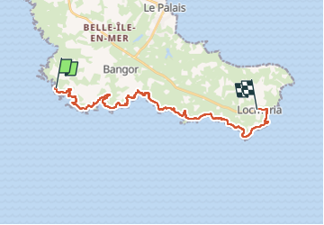
Départ du Palais par le bus jusqu'à Port Coton et retour en bus de Locmaria au Palais.
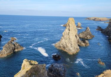
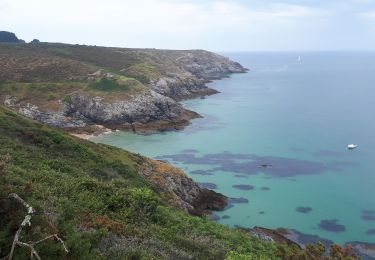
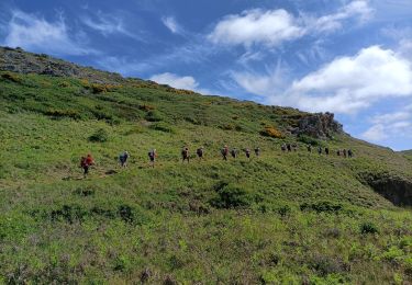
Côte sauvage très découpée à Port Coton avec ses aiguilles renommées.
Localisation
Pays :
France
Région :
Bretagne
Département/Province :
Morbihan
Commune :
Bangor
Localité :
Unknown
Départ:(Dec)
Départ:(UTM)
482039 ; 5239090 (30T) N.
Commentaires
Randonnées à proximité
![Randonnée Marche Bangor - bangor - Photo](https://media.geolcdn.com/t/375/260/ext.jpg?maxdim=2&url=https%3A%2F%2Fservices.sitytrail.com%2FGeolivesWS%2FDownloadMedia.ashx%3FTrailID%3D308558%26Media%3Dfix__20140530104824.jpg)
![Marche Marche](https://static1.geolcdn.com/sitytour/trail-icons/101.png)
bangor
Marche
Très facile
(1)
Bangor,
Bretagne,
Morbihan,
France
![](/images/other/stat-length.png)
9,4 km | 11,2 km-effort
2h 40min
![](https://static1.geolcdn.com/siteimages/upload/files/16400158638029165_repeat_loop_refresh_sync_direction_icon.png)
Oui
![Randonnée Marche Bangor - Belle île en mer - Photo](https://media.geolcdn.com/t/375/260/3a7f4183-98be-4dc7-9aad-ed1e320f25b2.jpg&format=jpg&maxdim=2)
![Marche Marche](https://static1.geolcdn.com/sitytour/trail-icons/101.png)
Belle île en mer
Marche
Très difficile
Bangor,
Bretagne,
Morbihan,
France
![](/images/other/stat-length.png)
64 km | 82 km-effort
15h 44min
![](https://static1.geolcdn.com/siteimages/upload/files/16400158638029165_repeat_loop_refresh_sync_direction_icon.png)
Non
![Randonnée Marche Bangor - J3 - Port Coton - Locmaria - 24 km - Photo](https://media.geolcdn.com/t/375/260/ext.jpg?maxdim=2&url=https%3A%2F%2Fstatic1.geolcdn.com%2Fsiteimages%2Fupload%2Ffiles%2F1553511878bg_sport_marche.png)
![Marche Marche](https://static1.geolcdn.com/sitytour/trail-icons/101.png)
J3 - Port Coton - Locmaria - 24 km
Marche
Très difficile
(1)
Bangor,
Bretagne,
Morbihan,
France
![](/images/other/stat-length.png)
24 km | 31 km-effort
7h 3min
![](https://static1.geolcdn.com/siteimages/upload/files/16400158638029165_repeat_loop_refresh_sync_direction_icon.png)
Non
![Randonnée Marche Bangor - 2-Port Coton - l'Apothicairerie à Belle Île en mer - Photo](https://media.geolcdn.com/t/375/260/5b3aba3d-6201-477b-b54e-bfc76b8e3758.jpg&format=jpg&maxdim=2)
![Marche Marche](https://static1.geolcdn.com/sitytour/trail-icons/101.png)
2-Port Coton - l'Apothicairerie à Belle Île en mer
Marche
Moyen
Bangor,
Bretagne,
Morbihan,
France
![](/images/other/stat-length.png)
13,7 km | 17,2 km-effort
2h 50min
![](https://static1.geolcdn.com/siteimages/upload/files/16400158638029165_repeat_loop_refresh_sync_direction_icon.png)
Non
![Randonnée Marche Bangor - GR340 BELLE-ILE jour 3 - Grand Large - Locmaria - Photo](https://media.geolcdn.com/t/375/260/8b1423fb-d98c-4bac-8258-679bd03de44c.jpg&format=jpg&maxdim=2)
![Marche Marche](https://static1.geolcdn.com/sitytour/trail-icons/101.png)
GR340 BELLE-ILE jour 3 - Grand Large - Locmaria
Marche
Difficile
Bangor,
Bretagne,
Morbihan,
France
![](/images/other/stat-length.png)
25 km | 32 km-effort
8h 5min
![](https://static1.geolcdn.com/siteimages/upload/files/16400158638029165_repeat_loop_refresh_sync_direction_icon.png)
Non
![Randonnée Marche Bangor - aiguilles de port Cotton - Photo](https://media.geolcdn.com/t/375/260/351bb440-7c45-45af-8626-d2213c10b99a.jpg&format=jpg&maxdim=2)
![Marche Marche](https://static1.geolcdn.com/sitytour/trail-icons/101.png)
aiguilles de port Cotton
Marche
Facile
Bangor,
Bretagne,
Morbihan,
France
![](/images/other/stat-length.png)
6,6 km | 7,9 km-effort
2h 3min
![](https://static1.geolcdn.com/siteimages/upload/files/16400158638029165_repeat_loop_refresh_sync_direction_icon.png)
Oui
![Randonnée A pied Bangor - Sentier du Stang Per - Photo](https://media.geolcdn.com/t/375/260/79d44e98-b1d5-40ac-81c7-6fc59deba8b2.jpeg&format=jpg&maxdim=2)
![A pied A pied](https://static1.geolcdn.com/sitytour/trail-icons/100.png)
Sentier du Stang Per
A pied
Facile
Bangor,
Bretagne,
Morbihan,
France
![](/images/other/stat-length.png)
5 km | 6,3 km-effort
1h 26min
![](https://static1.geolcdn.com/siteimages/upload/files/16400158638029165_repeat_loop_refresh_sync_direction_icon.png)
Oui
![Randonnée Marche Bangor - port cotton,Locmaria - Photo](https://media.geolcdn.com/t/375/260/8341e71a-a817-404b-9455-cd0135701718.jpg&format=jpg&maxdim=2)
![Marche Marche](https://static1.geolcdn.com/sitytour/trail-icons/101.png)
port cotton,Locmaria
Marche
Moyen
Bangor,
Bretagne,
Morbihan,
France
![](/images/other/stat-length.png)
19,6 km | 26 km-effort
5h 11min
![](https://static1.geolcdn.com/siteimages/upload/files/16400158638029165_repeat_loop_refresh_sync_direction_icon.png)
Non
![Randonnée Marche nordique Bangor - troisième étape belle ile - Photo](https://media.geolcdn.com/t/375/260/bd435c70-a294-44ac-b3d3-11527cf6c943.jpg&format=jpg&maxdim=2)
![Marche nordique Marche nordique](https://static1.geolcdn.com/sitytour/trail-icons/102.png)
troisième étape belle ile
Marche nordique
Très facile
Bangor,
Bretagne,
Morbihan,
France
![](/images/other/stat-length.png)
38 km | 47 km-effort
6h 21min
![](https://static1.geolcdn.com/siteimages/upload/files/16400158638029165_repeat_loop_refresh_sync_direction_icon.png)
Non