![](/images/other/stat-length.png)
![Randonnée Marche Rendeux - Hodister Adeps janvier 2022 modifiée.. - Photo](https://media.geolcdn.com/t/1900/400/ext.pjpeg?maxdim=2&url=https%3A%2F%2Fstatic1.geolcdn.com%2Fsiteimages%2Fupload%2Ffiles%2F1553511878bg_sport_marche.png)
Hodister Adeps janvier 2022 modifiée..
r.genette
Utilisateur
![Longueur](/images/other/stat-length.png)
Longueur
10,5 km
![Altitude max](https://static1.geolcdn.com/siteimages/upload/files/1508320355ic_sort_altitude_max_24dp.png)
Altitude max
412 m
![Dénivelé positif](https://static1.geolcdn.com/siteimages/upload/files/1508320355ic_sort_den_pos_24dp.png)
Dénivelé positif
276 m
![Km-Effort](/images/other/stat-length.png)
Km-Effort
14,2 km
![Altitude min](https://static1.geolcdn.com/siteimages/upload/files/1508320355ic_sort_altitude_min_24dp.png)
Altitude min
270 m
![Dénivelé négatif](https://static1.geolcdn.com/siteimages/upload/files/1508320355ic_sort_den_neg_24dp.png)
Dénivelé négatif
277 m
![Boucle](https://static1.geolcdn.com/siteimages/upload/files/16400158638029165_repeat_loop_refresh_sync_direction_icon.png)
Boucle
Oui
Date de création :
2022-09-08 11:23:59.815
Dernière modification :
2022-09-10 12:11:46.257
![Marche](https://static1.geolcdn.com/sitytour/trail-icons/101.png)
2h45
Difficulté : Moyen
![Scannez ce code QR pour ouvrir la randonnée dans l'application SityTrail](https://capi.geolives.com/qq0zvz2zws4bq2lad0pu/sitytour/trails/3384420/qr.png?size=200)
Application GPS de randonnée GRATUITE
À propos
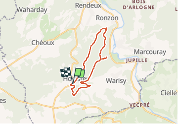
Randonnée Marche de 10,5 km à découvrir à Wallonie, Luxembourg, Rendeux. Cette randonnée est proposée par r.genette.
Description
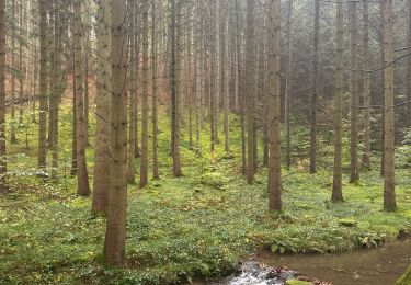
rando avec difficultés moyennes et très boisée..
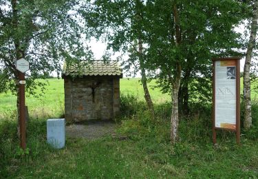
Petit détour pour découvrir l'Ermitage Saint Thibaut avec vue sur le village de Marcourt.
A conseiller...
Localisation
Pays :
Belgique
Région :
Wallonie
Département/Province :
Luxembourg
Commune :
Rendeux
Localité :
Unknown
Départ:(Dec)
Départ:(UTM)
677967 ; 5563650 (31U) N.
Commentaires
Randonnées à proximité
![Randonnée Marche Rendeux - Arboretum et Ourthe - Photo](https://media.geolcdn.com/t/375/260/ext.jpg?maxdim=2&url=https%3A%2F%2Fmedia.geolcdn.com%2Ff%2F114fab54-a809-4035-a129-83d982caf499.jpg)
![Marche Marche](https://static1.geolcdn.com/sitytour/trail-icons/101.png)
Arboretum et Ourthe
Marche
Moyen
(3)
Rendeux,
Wallonie,
Luxembourg,
Belgique
![](/images/other/stat-length.png)
9 km | 12 km-effort
3h 15min
![](https://static1.geolcdn.com/siteimages/upload/files/16400158638029165_repeat_loop_refresh_sync_direction_icon.png)
Oui
![Randonnée Marche Rendeux - hodister - Photo](https://media.geolcdn.com/t/375/260/ext.jpg?maxdim=2&url=https%3A%2F%2Fmedia.geolcdn.com%2Ff%2Fe73fbed5-6ae2-4bd7-8844-cc4756518ef2.jpg)
![Marche Marche](https://static1.geolcdn.com/sitytour/trail-icons/101.png)
hodister
Marche
Facile
(1)
Rendeux,
Wallonie,
Luxembourg,
Belgique
![](/images/other/stat-length.png)
8,8 km | 11,5 km-effort
3h 39min
![](https://static1.geolcdn.com/siteimages/upload/files/16400158638029165_repeat_loop_refresh_sync_direction_icon.png)
Oui
![Randonnée Marche Marche-en-Famenne - Grimbiémont-Lignières- boucle - Photo](https://media.geolcdn.com/t/375/260/ext.jpg?maxdim=2&url=https%3A%2F%2Fservices.sitytrail.com%2FGeolivesWS%2FDownloadMedia.ashx%3FTrailID%3D116546%26Media%3D492a6278-1252-4756-987d-ad86fac6f5d1.jpg)
![Marche Marche](https://static1.geolcdn.com/sitytour/trail-icons/101.png)
Grimbiémont-Lignières- boucle
Marche
Facile
(3)
Marche-en-Famenne,
Wallonie,
Luxembourg,
Belgique
![](/images/other/stat-length.png)
8,6 km | 11,6 km-effort
1h 59min
![](https://static1.geolcdn.com/siteimages/upload/files/16400158638029165_repeat_loop_refresh_sync_direction_icon.png)
Oui
![Randonnée Marche Rendeux - promenade de lourthe - Photo](https://media.geolcdn.com/t/375/260/ext.jpg?maxdim=2&url=https%3A%2F%2Fservices.sitytrail.com%2FGeolivesWS%2FDownloadMedia.ashx%3FTrailID%3D338833%26Media%3Dfix__20140824184151.jpg)
![Marche Marche](https://static1.geolcdn.com/sitytour/trail-icons/101.png)
promenade de lourthe
Marche
Difficile
(3)
Rendeux,
Wallonie,
Luxembourg,
Belgique
![](/images/other/stat-length.png)
8,1 km | 11 km-effort
2h 35min
![](https://static1.geolcdn.com/siteimages/upload/files/16400158638029165_repeat_loop_refresh_sync_direction_icon.png)
Oui
![Randonnée Marche Rendeux - Montaigu - Photo](https://media.geolcdn.com/t/375/260/ext.jpg?maxdim=2&url=https%3A%2F%2Fservices.sitytrail.com%2FGeolivesWS%2FDownloadMedia.ashx%3FTrailID%3D264121%26Media%3De6783db9-1bdf-46f4-876d-878e9e4b81fa.jpg)
![Marche Marche](https://static1.geolcdn.com/sitytour/trail-icons/101.png)
![Randonnée A pied Marche-en-Famenne - 11. Promenade Linaigrette - variante - Photo](https://media.geolcdn.com/t/375/260/ext.jpg?maxdim=2&url=https%3A%2F%2Fmedia.geolcdn.com%2Ff%2F0cf384e9-41c3-4fc8-9480-ba4d6ed2ce2c.jpeg)
![A pied A pied](https://static1.geolcdn.com/sitytour/trail-icons/100.png)
11. Promenade Linaigrette - variante
A pied
Facile
Marche-en-Famenne,
Wallonie,
Luxembourg,
Belgique
![](/images/other/stat-length.png)
4,2 km | 5,6 km-effort
1h 17min
![](https://static1.geolcdn.com/siteimages/upload/files/16400158638029165_repeat_loop_refresh_sync_direction_icon.png)
Oui
![Randonnée A pied Marche-en-Famenne - 11. Promenade Linaigrette - Photo](https://media.geolcdn.com/t/375/260/ext.jpg?maxdim=2&url=https%3A%2F%2Fmedia.geolcdn.com%2Ff%2Fa2868d48-9402-4be1-86c0-50ec017e3df7.jpeg)
![A pied A pied](https://static1.geolcdn.com/sitytour/trail-icons/100.png)
11. Promenade Linaigrette
A pied
Facile
Marche-en-Famenne,
Wallonie,
Luxembourg,
Belgique
![](/images/other/stat-length.png)
10,3 km | 12,8 km-effort
2h 54min
![](https://static1.geolcdn.com/siteimages/upload/files/16400158638029165_repeat_loop_refresh_sync_direction_icon.png)
Oui
![Randonnée Marche La Roche-en-Ardenne - La Roche n° 3 - Photo](https://media.geolcdn.com/t/375/260/ext.jpg?maxdim=2&url=https%3A%2F%2Fstatic1.geolcdn.com%2Fsiteimages%2Fupload%2Ffiles%2F1553511878bg_sport_marche.png)
![Marche Marche](https://static1.geolcdn.com/sitytour/trail-icons/101.png)
La Roche n° 3
Marche
Difficile
(1)
La Roche-en-Ardenne,
Wallonie,
Luxembourg,
Belgique
![](/images/other/stat-length.png)
11,1 km | 14,3 km-effort
3h 15min
![](https://static1.geolcdn.com/siteimages/upload/files/16400158638029165_repeat_loop_refresh_sync_direction_icon.png)
Oui
![Randonnée Marche Rendeux - Promenade Saint-Thibaut à Marcourt - Photo](https://media.geolcdn.com/t/375/260/ext.jpg?maxdim=2&url=https%3A%2F%2Fmedia.geolcdn.com%2Ff%2Fe150cdf8-feff-4370-88e9-c3a9404a91b3.jpeg)
![Marche Marche](https://static1.geolcdn.com/sitytour/trail-icons/101.png)
Promenade Saint-Thibaut à Marcourt
Marche
Très facile
(2)
Rendeux,
Wallonie,
Luxembourg,
Belgique
![](/images/other/stat-length.png)
9,1 km | 12,5 km-effort
4h 37min
![](https://static1.geolcdn.com/siteimages/upload/files/16400158638029165_repeat_loop_refresh_sync_direction_icon.png)
Oui