![](/images/other/stat-length.png)
![Randonnée Marche Sainte-Maure-de-Touraine - Sainte-Maure-de-Touraine - Fontaine St-Martin - 15.8km 160m 3h00 - 2006 05 08 - Photo](https://media.geolcdn.com/t/1900/400/23101f76-9ec7-4ab9-ad7c-cb2b26e854d0.jpg&format=pjpeg&maxdim=2)
Sainte-Maure-de-Touraine - Fontaine St-Martin - 15.8km 160m 3h00 - 2006 05 08
Orcal37
Utilisateur GUIDE
![Longueur](/images/other/stat-length.png)
Longueur
16,1 km
![Altitude max](https://static1.geolcdn.com/siteimages/upload/files/1508320355ic_sort_altitude_max_24dp.png)
Altitude max
118 m
![Dénivelé positif](https://static1.geolcdn.com/siteimages/upload/files/1508320355ic_sort_den_pos_24dp.png)
Dénivelé positif
165 m
![Km-Effort](/images/other/stat-length.png)
Km-Effort
18,3 km
![Altitude min](https://static1.geolcdn.com/siteimages/upload/files/1508320355ic_sort_altitude_min_24dp.png)
Altitude min
71 m
![Dénivelé négatif](https://static1.geolcdn.com/siteimages/upload/files/1508320355ic_sort_den_neg_24dp.png)
Dénivelé négatif
162 m
![Boucle](https://static1.geolcdn.com/siteimages/upload/files/16400158638029165_repeat_loop_refresh_sync_direction_icon.png)
Boucle
Oui
Date de création :
2022-09-08 08:52:41.434
Dernière modification :
2022-09-26 16:30:18.36
![Marche](https://static1.geolcdn.com/sitytour/trail-icons/101.png)
3h20
Difficulté : Moyen
![Scannez ce code QR pour ouvrir la randonnée dans l'application SityTrail](https://capi.geolives.com/qq0zvz2zws4bq2lad0pu/sitytour/trails/3383497/qr.png?size=200)
Application GPS de randonnée GRATUITE
À propos
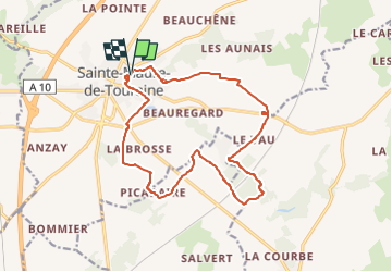
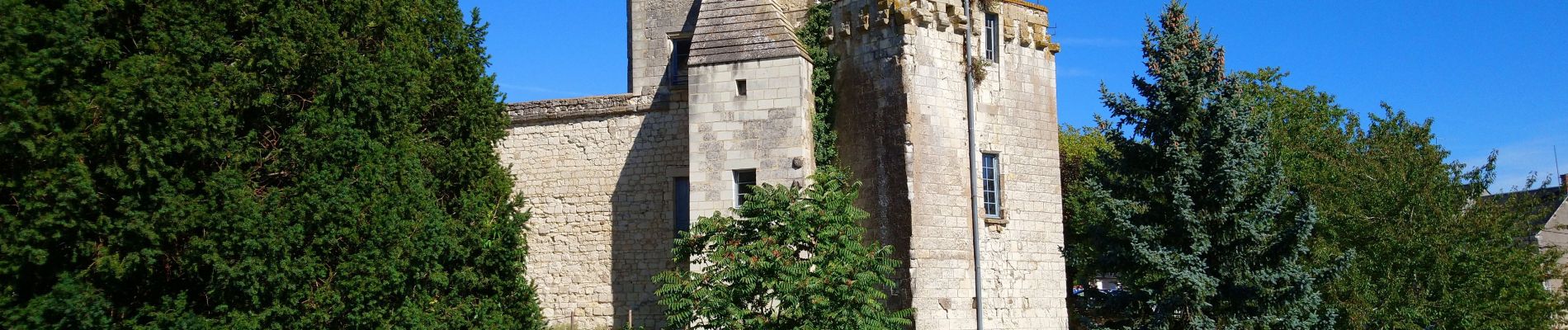
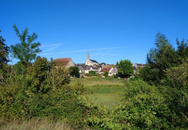
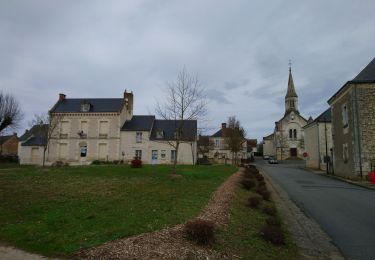
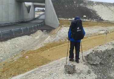
Randonnée Marche de 16,1 km à découvrir à Centre-Val de Loire, Indre-et-Loire, Sainte-Maure-de-Touraine. Cette randonnée est proposée par Orcal37.
Description
Sainte-Maure-de-Touraine - Fontaine St-Martin - Circuit de 2006 Pas de LGV en 2006 Ajouter 1.4km pour la contourner - 15.8km 160m 3h00 - 2006 05 08
Localisation
Pays :
France
Région :
Centre-Val de Loire
Département/Province :
Indre-et-Loire
Commune :
Sainte-Maure-de-Touraine
Localité :
Unknown
Départ:(Dec)
Départ:(UTM)
319563 ; 5220369 (31T) N.
Commentaires
Randonnées à proximité
![Randonnée Marche Sainte-Maure-de-Touraine - Sainte-Maure-de-Touraine - GR655 Sainte-Catherine-de-Fierbois - 23.7km 225m 5h10 (25mn) - 2022 09 11 - Photo](https://media.geolcdn.com/t/375/260/fc21a0f8-d614-4f40-afd9-4582a74a0c44.jpg&format=jpg&maxdim=2)
![Marche Marche](https://static1.geolcdn.com/sitytour/trail-icons/101.png)
Sainte-Maure-de-Touraine - GR655 Sainte-Catherine-de-Fierbois - 23.7km 225m 5...
Marche
Facile
Sainte-Maure-de-Touraine,
Centre-Val de Loire,
Indre-et-Loire,
France
![](/images/other/stat-length.png)
24 km | 27 km-effort
5h 10min
![](https://static1.geolcdn.com/siteimages/upload/files/16400158638029165_repeat_loop_refresh_sync_direction_icon.png)
Oui
![Randonnée Marche Noyant-de-Touraine - Noyant-de-Touraine - PR - 14.5km 170m 3h15 - 2021 02 20 - Photo](https://media.geolcdn.com/t/375/260/14b9ad82-44eb-45d7-a342-a57783cfb838.jpg&format=jpg&maxdim=2)
![Marche Marche](https://static1.geolcdn.com/sitytour/trail-icons/101.png)
Noyant-de-Touraine - PR - 14.5km 170m 3h15 - 2021 02 20
Marche
Facile
Noyant-de-Touraine,
Centre-Val de Loire,
Indre-et-Loire,
France
![](/images/other/stat-length.png)
14,5 km | 16,8 km-effort
3h 15min
![](https://static1.geolcdn.com/siteimages/upload/files/16400158638029165_repeat_loop_refresh_sync_direction_icon.png)
Oui
![Randonnée Marche Sainte-Maure-de-Touraine - JFT YB ETAPE3 29-4-2014 - Photo](https://media.geolcdn.com/t/375/260/ext.jpg?maxdim=2&url=https%3A%2F%2Fservices.sitytrail.com%2FGeolivesWS%2FDownloadMedia.ashx%3FTrailID%3D271864%26Media%3Dfix__20140429093845.jpg)
![Marche Marche](https://static1.geolcdn.com/sitytour/trail-icons/101.png)
JFT YB ETAPE3 29-4-2014
Marche
Facile
Sainte-Maure-de-Touraine,
Centre-Val de Loire,
Indre-et-Loire,
France
![](/images/other/stat-length.png)
29 km | 31 km-effort
6h 15min
![](https://static1.geolcdn.com/siteimages/upload/files/16400158638029165_repeat_loop_refresh_sync_direction_icon.png)
Non
![Randonnée V.T.T. Sainte-Maure-de-Touraine - De Sainte Maure à Saint Epain - Photo](https://media.geolcdn.com/t/375/260/ext.jpg?maxdim=2&url=https%3A%2F%2Fservices.sitytrail.com%2FGeolivesWS%2FDownloadMedia.ashx%3FTrailID%3D101424%26Media%3D1385_1.jpg)
![V.T.T. V.T.T.](https://static1.geolcdn.com/sitytour/trail-icons/202.png)
De Sainte Maure à Saint Epain
V.T.T.
Moyen
Sainte-Maure-de-Touraine,
Centre-Val de Loire,
Indre-et-Loire,
France
![](/images/other/stat-length.png)
24 km | 27 km-effort
1h 30min
![](https://static1.geolcdn.com/siteimages/upload/files/16400158638029165_repeat_loop_refresh_sync_direction_icon.png)
Oui
![Randonnée V.T.T. Noyant-de-Touraine - Noyant-en-Touraine 2023 - Photo](https://media.geolcdn.com/t/375/260/ext.jpg?maxdim=2&url=https%3A%2F%2Fstatic1.geolcdn.com%2Fsiteimages%2Fupload%2Ffiles%2F1524743154velo.jpg)
![V.T.T. V.T.T.](https://static1.geolcdn.com/sitytour/trail-icons/202.png)
Noyant-en-Touraine 2023
V.T.T.
Très difficile
Noyant-de-Touraine,
Centre-Val de Loire,
Indre-et-Loire,
France
![](/images/other/stat-length.png)
47 km | 55 km-effort
3h 48min
![](https://static1.geolcdn.com/siteimages/upload/files/16400158638029165_repeat_loop_refresh_sync_direction_icon.png)
Oui
![Randonnée Marche Sainte-Maure-de-Touraine - 016 Sainte Maure Ormes - Photo](https://media.geolcdn.com/t/375/260/ext.jpg?maxdim=2&url=https%3A%2F%2Fstatic1.geolcdn.com%2Fsiteimages%2Fupload%2Ffiles%2F1553511878bg_sport_marche.png)
![Marche Marche](https://static1.geolcdn.com/sitytour/trail-icons/101.png)
016 Sainte Maure Ormes
Marche
Très facile
Sainte-Maure-de-Touraine,
Centre-Val de Loire,
Indre-et-Loire,
France
![](/images/other/stat-length.png)
19,5 km | 21 km-effort
4h 43min
![](https://static1.geolcdn.com/siteimages/upload/files/16400158638029165_repeat_loop_refresh_sync_direction_icon.png)
Non
![Randonnée Marche Sepmes - Roundtrip Sepmes - Photo](https://media.geolcdn.com/t/375/260/ext.jpg?maxdim=2&url=https%3A%2F%2Fstatic1.geolcdn.com%2Fsiteimages%2Fupload%2Ffiles%2F1553511878bg_sport_marche.png)
![Marche Marche](https://static1.geolcdn.com/sitytour/trail-icons/101.png)
Roundtrip Sepmes
Marche
Très facile
Sepmes,
Centre-Val de Loire,
Indre-et-Loire,
France
![](/images/other/stat-length.png)
7,5 km | 8,5 km-effort
Inconnu
![](https://static1.geolcdn.com/siteimages/upload/files/16400158638029165_repeat_loop_refresh_sync_direction_icon.png)
Oui
![Randonnée Vélo électrique Sainte-Maure-de-Touraine - 2-Ste Maure de Touraine-Chatellerault - Photo](https://media.geolcdn.com/t/375/260/ext.jpg?maxdim=2&url=https%3A%2F%2Fstatic1.geolcdn.com%2Fsiteimages%2Fupload%2Ffiles%2F1524743154velo.jpg)
![Vélo électrique Vélo électrique](https://static1.geolcdn.com/sitytour/trail-icons/205.png)
2-Ste Maure de Touraine-Chatellerault
Vélo électrique
Très facile
Sainte-Maure-de-Touraine,
Centre-Val de Loire,
Indre-et-Loire,
France
![](/images/other/stat-length.png)
41 km | 45 km-effort
Inconnu
![](https://static1.geolcdn.com/siteimages/upload/files/16400158638029165_repeat_loop_refresh_sync_direction_icon.png)
Non
![Randonnée V.T.T. Sainte-Maure-de-Touraine - 2018-10-01 Sainte Maure-Poitiers 90 km - Photo](https://media.geolcdn.com/t/375/260/ext.jpg?maxdim=2&url=https%3A%2F%2Fstatic1.geolcdn.com%2Fsiteimages%2Fupload%2Ffiles%2F1524743154velo.jpg)
![V.T.T. V.T.T.](https://static1.geolcdn.com/sitytour/trail-icons/202.png)
2018-10-01 Sainte Maure-Poitiers 90 km
V.T.T.
Moyen
Sainte-Maure-de-Touraine,
Centre-Val de Loire,
Indre-et-Loire,
France
![](/images/other/stat-length.png)
88 km | 100 km-effort
7h 1min
![](https://static1.geolcdn.com/siteimages/upload/files/16400158638029165_repeat_loop_refresh_sync_direction_icon.png)
Non