![](/images/other/stat-length.png)
![Randonnée Marche Conteville-lès-Boulogne - La Fontaine aux Charmes - Photo](https://media.geolcdn.com/t/1900/400/ext.pjpeg?maxdim=2&url=https%3A%2F%2Fstatic1.geolcdn.com%2Fsiteimages%2Fupload%2Ffiles%2F1553511878bg_sport_marche.png)
La Fontaine aux Charmes
philippe.vdv
Utilisateur
![Longueur](/images/other/stat-length.png)
Longueur
6 km
![Altitude max](https://static1.geolcdn.com/siteimages/upload/files/1508320355ic_sort_altitude_max_24dp.png)
Altitude max
74 m
![Dénivelé positif](https://static1.geolcdn.com/siteimages/upload/files/1508320355ic_sort_den_pos_24dp.png)
Dénivelé positif
87 m
![Km-Effort](/images/other/stat-length.png)
Km-Effort
7,2 km
![Altitude min](https://static1.geolcdn.com/siteimages/upload/files/1508320355ic_sort_altitude_min_24dp.png)
Altitude min
26 m
![Dénivelé négatif](https://static1.geolcdn.com/siteimages/upload/files/1508320355ic_sort_den_neg_24dp.png)
Dénivelé négatif
87 m
![Boucle](https://static1.geolcdn.com/siteimages/upload/files/16400158638029165_repeat_loop_refresh_sync_direction_icon.png)
Boucle
Oui
Date de création :
2022-09-05 14:15:36.18
Dernière modification :
2022-09-05 14:16:16.191
![Marche](https://static1.geolcdn.com/sitytour/trail-icons/101.png)
1h37
Difficulté : Moyen
![Scannez ce code QR pour ouvrir la randonnée dans l'application SityTrail](https://capi.geolives.com/qq0zvz2zws4bq2lad0pu/sitytour/trails/3380459/qr.png?size=200)
Application GPS de randonnée GRATUITE
À propos
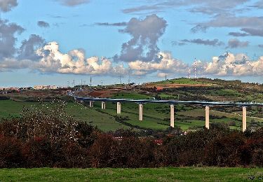
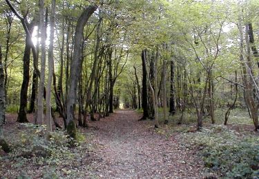
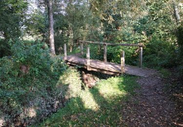
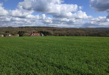
Randonnée Marche de 6 km à découvrir à Hauts-de-France, Pas-de-Calais, Conteville-lès-Boulogne. Cette randonnée est proposée par philippe.vdv.
Description
C’est une agréable balade dans l’arrière-pays Boulonnais qui vous mènera le long du Wimereux et dans la forêt domaniale de Boulogne. Massif forestier de plus de 2000 hectares plantés d’espèces nobles (hêtres, charmes…) et abritant de nombreux oiseaux.
Localisation
Pays :
France
Région :
Hauts-de-France
Département/Province :
Pas-de-Calais
Commune :
Conteville-lès-Boulogne
Localité :
Unknown
Départ:(Dec)
Départ:(UTM)
410497 ; 5622145 (31U) N.
Commentaires
Randonnées à proximité
![Randonnée Marche Baincthun - Sentier de la Pierre de Baincthun - Photo](https://media.geolcdn.com/t/375/260/ext.jpg?maxdim=2&url=https%3A%2F%2Fservices.sitytrail.com%2FGeolivesWS%2FDownloadMedia.ashx%3FTrailID%3D317846%26Media%3D17222_4.jpg)
![Marche Marche](https://static1.geolcdn.com/sitytour/trail-icons/101.png)
Sentier de la Pierre de Baincthun
Marche
Facile
(1)
Baincthun,
Hauts-de-France,
Pas-de-Calais,
France
![](/images/other/stat-length.png)
4 km | 5,2 km-effort
1h 19min
![](https://static1.geolcdn.com/siteimages/upload/files/16400158638029165_repeat_loop_refresh_sync_direction_icon.png)
Oui
![Randonnée Marche La Capelle-lès-Boulogne - Sentier des Aulnes - La Capelle-lès-Boulogne - Photo](https://media.geolcdn.com/t/375/260/ext.jpg?maxdim=2&url=https%3A%2F%2Fservices.sitytrail.com%2FGeolivesWS%2FDownloadMedia.ashx%3FTrailID%3D317839%26Media%3D17215_4.jpg)
![Marche Marche](https://static1.geolcdn.com/sitytour/trail-icons/101.png)
Sentier des Aulnes - La Capelle-lès-Boulogne
Marche
Facile
La Capelle-lès-Boulogne,
Hauts-de-France,
Pas-de-Calais,
France
![](/images/other/stat-length.png)
3,3 km | 3,7 km-effort
1h 0min
![](https://static1.geolcdn.com/siteimages/upload/files/16400158638029165_repeat_loop_refresh_sync_direction_icon.png)
Oui
![Randonnée Vélo Le Wast - La vallée du Wimereux - Le Wast - Photo](https://media.geolcdn.com/t/375/260/ext.jpg?maxdim=2&url=https%3A%2F%2Fservices.sitytrail.com%2FGeolivesWS%2FDownloadMedia.ashx%3FTrailID%3D111983%26Media%3D9326_6.jpg)
![Vélo Vélo](https://static1.geolcdn.com/sitytour/trail-icons/200.png)
La vallée du Wimereux - Le Wast
Vélo
Moyen
Le Wast,
Hauts-de-France,
Pas-de-Calais,
France
![](/images/other/stat-length.png)
30 km | 35 km-effort
3h 0min
![](https://static1.geolcdn.com/siteimages/upload/files/16400158638029165_repeat_loop_refresh_sync_direction_icon.png)
Oui
![Randonnée A pied Maninghen-Henne - Sentier Le Rendal - Photo](https://media.geolcdn.com/t/375/260/ext.jpg?maxdim=2&url=https%3A%2F%2Fmedia.geolcdn.com%2Ff%2F1d61022c-2aaf-46a0-b994-eaf40efecb66.jpeg)
![A pied A pied](https://static1.geolcdn.com/sitytour/trail-icons/100.png)
Sentier Le Rendal
A pied
Facile
Maninghen-Henne,
Hauts-de-France,
Pas-de-Calais,
France
![](/images/other/stat-length.png)
4,5 km | 5,4 km-effort
1h 13min
![](https://static1.geolcdn.com/siteimages/upload/files/16400158638029165_repeat_loop_refresh_sync_direction_icon.png)
Oui
![Randonnée Marche La Capelle-lès-Boulogne - randonnée Contevilloise - Photo](https://media.geolcdn.com/t/375/260/ext.jpg?maxdim=2&url=https%3A%2F%2Fmedia.geolcdn.com%2Ff%2F9b6b9f34-6eca-4d40-b7d7-5ce2ee057578.jpg)
![Marche Marche](https://static1.geolcdn.com/sitytour/trail-icons/101.png)
randonnée Contevilloise
Marche
Difficile
La Capelle-lès-Boulogne,
Hauts-de-France,
Pas-de-Calais,
France
![](/images/other/stat-length.png)
10,4 km | 12,3 km-effort
8h 23min
![](https://static1.geolcdn.com/siteimages/upload/files/16400158638029165_repeat_loop_refresh_sync_direction_icon.png)
Oui
![Randonnée Marche La Capelle-lès-Boulogne - randonnée Capelloise - Photo](https://media.geolcdn.com/t/375/260/ext.jpg?maxdim=2&url=https%3A%2F%2Fmedia.geolcdn.com%2Ff%2Fa3b0a2cd-1248-41ed-9bf0-ed79ba598804.jpg)
![Marche Marche](https://static1.geolcdn.com/sitytour/trail-icons/101.png)
randonnée Capelloise
Marche
Facile
La Capelle-lès-Boulogne,
Hauts-de-France,
Pas-de-Calais,
France
![](/images/other/stat-length.png)
6,2 km | 7 km-effort
2h 26min
![](https://static1.geolcdn.com/siteimages/upload/files/16400158638029165_repeat_loop_refresh_sync_direction_icon.png)
Oui
![Randonnée Marche Conteville-lès-Boulogne - La Fontaine aux Charmes - Conteville-lès-Boulogne - Photo](https://media.geolcdn.com/t/375/260/ext.jpg?maxdim=2&url=https%3A%2F%2Fservices.sitytrail.com%2FGeolivesWS%2FDownloadMedia.ashx%3FTrailID%3D112084%26Media%3D9812_2.jpg)
![Marche Marche](https://static1.geolcdn.com/sitytour/trail-icons/101.png)
La Fontaine aux Charmes - Conteville-lès-Boulogne
Marche
Facile
(1)
Conteville-lès-Boulogne,
Hauts-de-France,
Pas-de-Calais,
France
![](/images/other/stat-length.png)
5,8 km | 6,9 km-effort
1h 30min
![](https://static1.geolcdn.com/siteimages/upload/files/16400158638029165_repeat_loop_refresh_sync_direction_icon.png)
Oui
![Randonnée sport Baincthun - Sentier de la Marguerite - Photo](https://media.geolcdn.com/t/375/260/ext.jpg?maxdim=2&url=https%3A%2F%2Fsecurestorage.geolives.com%2Fsitytour%2Ftrail-bg%2Fdefault.jpg)
Sentier de la Marguerite
sport
Très facile
(1)
Baincthun,
Hauts-de-France,
Pas-de-Calais,
France
![](/images/other/stat-length.png)
14 km | 18,2 km-effort
Inconnu
![](https://static1.geolcdn.com/siteimages/upload/files/16400158638029165_repeat_loop_refresh_sync_direction_icon.png)
Oui
![Randonnée Vélo Le Wast - La vallée du Wimereux - Le Wast - Photo](https://media.geolcdn.com/t/375/260/ext.jpg?maxdim=2&url=https%3A%2F%2Fstatic1.geolcdn.com%2Fsiteimages%2Fupload%2Ffiles%2F1524743154velo.jpg)
![Vélo Vélo](https://static1.geolcdn.com/sitytour/trail-icons/200.png)
La vallée du Wimereux - Le Wast
Vélo
Moyen
Le Wast,
Hauts-de-France,
Pas-de-Calais,
France
![](/images/other/stat-length.png)
30 km | 34 km-effort
3h 0min
![](https://static1.geolcdn.com/siteimages/upload/files/16400158638029165_repeat_loop_refresh_sync_direction_icon.png)
Oui