![](/images/other/stat-length.png)
![Randonnée Marche Montredon-Labessonnié - 81-Montredon Labessonnie-sentier de Houlette - Photo](https://media.geolcdn.com/t/1900/400/ext.pjpeg?maxdim=2&url=https%3A%2F%2Fstatic1.geolcdn.com%2Fsiteimages%2Fupload%2Ffiles%2F1553511878bg_sport_marche.png)
81-Montredon Labessonnie-sentier de Houlette
Jovila
Utilisateur
![Longueur](/images/other/stat-length.png)
Longueur
20 km
![Altitude max](https://static1.geolcdn.com/siteimages/upload/files/1508320355ic_sort_altitude_max_24dp.png)
Altitude max
643 m
![Dénivelé positif](https://static1.geolcdn.com/siteimages/upload/files/1508320355ic_sort_den_pos_24dp.png)
Dénivelé positif
483 m
![Km-Effort](/images/other/stat-length.png)
Km-Effort
27 km
![Altitude min](https://static1.geolcdn.com/siteimages/upload/files/1508320355ic_sort_altitude_min_24dp.png)
Altitude min
319 m
![Dénivelé négatif](https://static1.geolcdn.com/siteimages/upload/files/1508320355ic_sort_den_neg_24dp.png)
Dénivelé négatif
483 m
![Boucle](https://static1.geolcdn.com/siteimages/upload/files/16400158638029165_repeat_loop_refresh_sync_direction_icon.png)
Boucle
Oui
Date de création :
2022-09-04 07:24:21.567
Dernière modification :
2022-09-04 20:11:27.707
![Marche](https://static1.geolcdn.com/sitytour/trail-icons/101.png)
4h21
Difficulté : Moyen
![Scannez ce code QR pour ouvrir la randonnée dans l'application SityTrail](https://capi.geolives.com/qq0zvz2zws4bq2lad0pu/sitytour/trails/3379031/qr.png?size=200)
Application GPS de randonnée GRATUITE
À propos
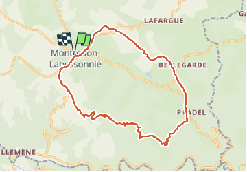
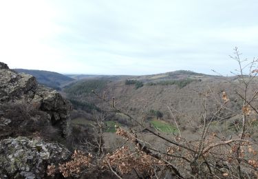
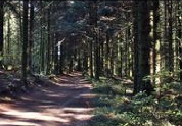
Randonnée Marche de 20 km à découvrir à Occitanie, Tarn, Montredon-Labessonnié. Cette randonnée est proposée par Jovila.
Description
Beaucoup de routes à éviter pendant les grosses chaleurs !!!
Se garer au parking de l eglise -
Débuter la rando en prenant direction Arifat puis 2e à gauche.
Localisation
Pays :
France
Région :
Occitanie
Département/Province :
Tarn
Commune :
Montredon-Labessonnié
Localité :
Unknown
Départ:(Dec)
Départ:(UTM)
445685 ; 4841074 (31T) N.
Commentaires
Randonnées à proximité
![Randonnée A pied Montredon-Labessonnié - Sentier de la Quille du Roy - Photo](https://media.geolcdn.com/t/375/260/2f958672-3170-4080-84b8-f6fd5882238e.jpeg&format=jpg&maxdim=2)
![A pied A pied](https://static1.geolcdn.com/sitytour/trail-icons/100.png)
Sentier de la Quille du Roy
A pied
Facile
Montredon-Labessonnié,
Occitanie,
Tarn,
France
![](/images/other/stat-length.png)
8,3 km | 11,1 km-effort
2h 31min
![](https://static1.geolcdn.com/siteimages/upload/files/16400158638029165_repeat_loop_refresh_sync_direction_icon.png)
Non
![Marche Marche](https://static1.geolcdn.com/sitytour/trail-icons/101.png)
Sentier des agates revisité
Marche
Facile
Montredon-Labessonnié,
Occitanie,
Tarn,
France
![](/images/other/stat-length.png)
14,4 km | 20 km-effort
3h 44min
![](https://static1.geolcdn.com/siteimages/upload/files/16400158638029165_repeat_loop_refresh_sync_direction_icon.png)
Oui
![Randonnée Marche Montredon-Labessonnié - Sentier de la Baronnie - Photo](https://media.geolcdn.com/t/375/260/8c6a40d7-62fe-4835-92f3-afcebbd18a6f.jpeg&format=jpg&maxdim=2)
![Marche Marche](https://static1.geolcdn.com/sitytour/trail-icons/101.png)
Sentier de la Baronnie
Marche
Très facile
Montredon-Labessonnié,
Occitanie,
Tarn,
France
![](/images/other/stat-length.png)
19,7 km | 27 km-effort
6h 29min
![](https://static1.geolcdn.com/siteimages/upload/files/16400158638029165_repeat_loop_refresh_sync_direction_icon.png)
Oui
![Randonnée V.T.T. Montredon-Labessonnié - Montredon-Labessonnié - Photo](https://media.geolcdn.com/t/375/260/ext.jpg?maxdim=2&url=https%3A%2F%2Fservices.sitytrail.com%2FGeolivesWS%2FDownloadMedia.ashx%3FTrailID%3D100877%26Media%3D374_2.jpg)
![V.T.T. V.T.T.](https://static1.geolcdn.com/sitytour/trail-icons/202.png)
Montredon-Labessonnié
V.T.T.
Difficile
Montredon-Labessonnié,
Occitanie,
Tarn,
France
![](/images/other/stat-length.png)
29 km | 41 km-effort
2h 0min
![](https://static1.geolcdn.com/siteimages/upload/files/16400158638029165_repeat_loop_refresh_sync_direction_icon.png)
Non
![Randonnée Marche Montredon-Labessonnié - lacazalié - Photo](https://media.geolcdn.com/t/375/260/4f38dbed-2fc8-4285-81f4-2773a54df5f1.jpg&format=jpg&maxdim=2)
![Marche Marche](https://static1.geolcdn.com/sitytour/trail-icons/101.png)
lacazalié
Marche
Moyen
Montredon-Labessonnié,
Occitanie,
Tarn,
France
![](/images/other/stat-length.png)
2,3 km | 3,4 km-effort
1h 16min
![](https://static1.geolcdn.com/siteimages/upload/files/16400158638029165_repeat_loop_refresh_sync_direction_icon.png)
Non
![Randonnée Marche Montredon-Labessonnié - Arifat à Lagrifoul (Montredon Labessonie) - Photo](https://media.geolcdn.com/t/375/260/ext.jpg?maxdim=2&url=https%3A%2F%2Fstatic1.geolcdn.com%2Fsiteimages%2Fupload%2Ffiles%2F1553511878bg_sport_marche.png)
![Marche Marche](https://static1.geolcdn.com/sitytour/trail-icons/101.png)
Arifat à Lagrifoul (Montredon Labessonie)
Marche
Moyen
Montredon-Labessonnié,
Occitanie,
Tarn,
France
![](/images/other/stat-length.png)
20 km | 30 km-effort
6h 4min
![](https://static1.geolcdn.com/siteimages/upload/files/16400158638029165_repeat_loop_refresh_sync_direction_icon.png)
Oui
![Randonnée Marche Montredon-Labessonnié - 81_Montredon_Quille du Roy - Photo](https://media.geolcdn.com/t/375/260/ext.jpg?maxdim=2&url=https%3A%2F%2Fstatic1.geolcdn.com%2Fsiteimages%2Fupload%2Ffiles%2F1553511878bg_sport_marche.png)
![Marche Marche](https://static1.geolcdn.com/sitytour/trail-icons/101.png)
81_Montredon_Quille du Roy
Marche
Très facile
Montredon-Labessonnié,
Occitanie,
Tarn,
France
![](/images/other/stat-length.png)
15,4 km | 21 km-effort
Inconnu
![](https://static1.geolcdn.com/siteimages/upload/files/16400158638029165_repeat_loop_refresh_sync_direction_icon.png)
Non
![Randonnée Moteur Terre-de-Bancalié - rando 4X4 - Photo](https://media.geolcdn.com/t/375/260/ext.jpg?maxdim=2&url=https%3A%2F%2Fstatic1.geolcdn.com%2Fsiteimages%2Fupload%2Ffiles%2F15247431544x4.jpg)
![Moteur Moteur](https://static1.geolcdn.com/sitytour/trail-icons/400.png)
rando 4X4
Moteur
Moyen
Terre-de-Bancalié,
Occitanie,
Tarn,
France
![](/images/other/stat-length.png)
85 km | 118 km-effort
3h 25min
![](https://static1.geolcdn.com/siteimages/upload/files/16400158638029165_repeat_loop_refresh_sync_direction_icon.png)
Non
![Randonnée Marche Arifat - Cascades de Arifat - Photo](https://media.geolcdn.com/t/375/260/ext.jpg?maxdim=2&url=https%3A%2F%2Fstatic1.geolcdn.com%2Fsiteimages%2Fupload%2Ffiles%2F1553511878bg_sport_marche.png)
![Marche Marche](https://static1.geolcdn.com/sitytour/trail-icons/101.png)
Cascades de Arifat
Marche
Moyen
Arifat,
Occitanie,
Tarn,
France
![](/images/other/stat-length.png)
8,7 km | 13,1 km-effort
2h 39min
![](https://static1.geolcdn.com/siteimages/upload/files/16400158638029165_repeat_loop_refresh_sync_direction_icon.png)
Oui