![](/images/other/stat-length.png)
![Randonnée Marche As - Porte d'entrée - Gare d'As - rouge - Photo](https://media.geolcdn.com/t/1900/400/ext.pjpeg?maxdim=2&url=https%3A%2F%2Fstatic1.geolcdn.com%2Fsiteimages%2Fupload%2Ffiles%2F1553511878bg_sport_marche.png)
Porte d'entrée - Gare d'As - rouge
mumu.larandonneuse
Utilisateur GUIDE
![Longueur](/images/other/stat-length.png)
Longueur
15,8 km
![Altitude max](https://static1.geolcdn.com/siteimages/upload/files/1508320355ic_sort_altitude_max_24dp.png)
Altitude max
102 m
![Dénivelé positif](https://static1.geolcdn.com/siteimages/upload/files/1508320355ic_sort_den_pos_24dp.png)
Dénivelé positif
141 m
![Km-Effort](/images/other/stat-length.png)
Km-Effort
17,7 km
![Altitude min](https://static1.geolcdn.com/siteimages/upload/files/1508320355ic_sort_altitude_min_24dp.png)
Altitude min
59 m
![Dénivelé négatif](https://static1.geolcdn.com/siteimages/upload/files/1508320355ic_sort_den_neg_24dp.png)
Dénivelé négatif
141 m
![Boucle](https://static1.geolcdn.com/siteimages/upload/files/16400158638029165_repeat_loop_refresh_sync_direction_icon.png)
Boucle
Oui
Date de création :
2022-09-01 10:46:01.047
Dernière modification :
2022-09-01 10:53:51.866
![Marche](https://static1.geolcdn.com/sitytour/trail-icons/101.png)
4h01
Difficulté : Facile
![Scannez ce code QR pour ouvrir la randonnée dans l'application SityTrail](https://capi.geolives.com/qq0zvz2zws4bq2lad0pu/sitytour/trails/3375138/qr.png?size=200)
Application GPS de randonnée GRATUITE
À propos
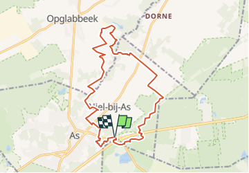
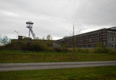
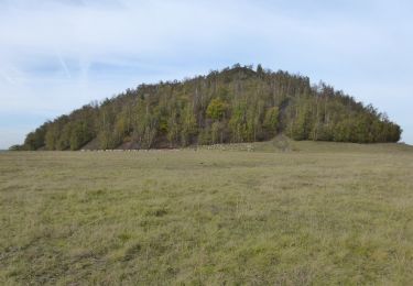
Randonnée Marche de 15,8 km à découvrir à Flandre, Limbourg, As. Cette randonnée est proposée par mumu.larandonneuse.
Description
Balade balisée rouge.
Gpx pris sur le site du Hoge Kempen.
📌 Porte d'entrée Gare d'As (une des 6 portes d'entrée du Parc National)
Localisation
Pays :
Belgique
Région :
Flandre
Département/Province :
Limbourg
Commune :
As
Localité :
As
Départ:(Dec)
Départ:(UTM)
682639 ; 5653694 (31U) N.
Commentaires
Randonnées à proximité
![Randonnée Marche Maasmechelen - Mechelse Heide - Photo](https://media.geolcdn.com/t/375/260/501f02e9-8086-4be8-98c9-f01120ddee06.jpg&format=jpg&maxdim=2)
![Marche Marche](https://static1.geolcdn.com/sitytour/trail-icons/101.png)
Mechelse Heide
Marche
Facile
(2)
Maasmechelen,
Flandre,
Limbourg,
Belgique
![](/images/other/stat-length.png)
14,2 km | 16,2 km-effort
3h 41min
![](https://static1.geolcdn.com/siteimages/upload/files/16400158638029165_repeat_loop_refresh_sync_direction_icon.png)
Oui
![Randonnée A pied As - Mechelse Heide Noord - Photo](https://media.geolcdn.com/t/375/260/6c3d6be9-86c4-472e-82c2-64c07d2c49aa.jpeg&format=jpg&maxdim=2)
![A pied A pied](https://static1.geolcdn.com/sitytour/trail-icons/100.png)
Mechelse Heide Noord
A pied
Facile
As,
Flandre,
Limbourg,
Belgique
![](/images/other/stat-length.png)
4,3 km | 4,8 km-effort
1h 5min
![](https://static1.geolcdn.com/siteimages/upload/files/16400158638029165_repeat_loop_refresh_sync_direction_icon.png)
Non
![Randonnée A pied Oudsbergen - Moorsberg Paarse trapezium - Photo](https://media.geolcdn.com/t/375/260/4c7fd886-c3d5-4662-96ec-c951a3de83c7.jpeg&format=jpg&maxdim=2)
![A pied A pied](https://static1.geolcdn.com/sitytour/trail-icons/100.png)
Moorsberg Paarse trapezium
A pied
Facile
Oudsbergen,
Flandre,
Limbourg,
Belgique
![](/images/other/stat-length.png)
6,3 km | 7 km-effort
1h 35min
![](https://static1.geolcdn.com/siteimages/upload/files/16400158638029165_repeat_loop_refresh_sync_direction_icon.png)
Oui
![Randonnée A pied As - Heiderbos blauwe ruit - Photo](https://media.geolcdn.com/t/375/260/e65c145e-dca4-4d58-ae17-fc8ca78c84c8.jpeg&format=jpg&maxdim=2)
![A pied A pied](https://static1.geolcdn.com/sitytour/trail-icons/100.png)
Heiderbos blauwe ruit
A pied
Facile
As,
Flandre,
Limbourg,
Belgique
![](/images/other/stat-length.png)
7,7 km | 8,5 km-effort
1h 56min
![](https://static1.geolcdn.com/siteimages/upload/files/16400158638029165_repeat_loop_refresh_sync_direction_icon.png)
Oui
![Randonnée A pied Genk - Thorpark Groene rechthoek - Photo](https://media.geolcdn.com/t/375/260/5d7a6518-21eb-43eb-96c3-b85d7a924753.jpeg&format=jpg&maxdim=2)
![A pied A pied](https://static1.geolcdn.com/sitytour/trail-icons/100.png)
Thorpark Groene rechthoek
A pied
Facile
Genk,
Flandre,
Limbourg,
Belgique
![](/images/other/stat-length.png)
4,1 km | 4,4 km-effort
1h 0min
![](https://static1.geolcdn.com/siteimages/upload/files/16400158638029165_repeat_loop_refresh_sync_direction_icon.png)
Oui
![Randonnée A pied Genk - Thorpark - De Kolonie Rode driehoek - Photo](https://media.geolcdn.com/t/375/260/1c715178-bd32-42a8-8c79-dfbf5aac80a5.jpeg&format=jpg&maxdim=2)
![A pied A pied](https://static1.geolcdn.com/sitytour/trail-icons/100.png)
Thorpark - De Kolonie Rode driehoek
A pied
Facile
Genk,
Flandre,
Limbourg,
Belgique
![](/images/other/stat-length.png)
12,5 km | 14,1 km-effort
3h 12min
![](https://static1.geolcdn.com/siteimages/upload/files/16400158638029165_repeat_loop_refresh_sync_direction_icon.png)
Oui
![Randonnée A pied Genk - Thorpark Blauwe ruit - Photo](https://media.geolcdn.com/t/375/260/5d7a6518-21eb-43eb-96c3-b85d7a924753.jpeg&format=jpg&maxdim=2)
![A pied A pied](https://static1.geolcdn.com/sitytour/trail-icons/100.png)
Thorpark Blauwe ruit
A pied
Facile
Genk,
Flandre,
Limbourg,
Belgique
![](/images/other/stat-length.png)
7,6 km | 8,7 km-effort
1h 58min
![](https://static1.geolcdn.com/siteimages/upload/files/16400158638029165_repeat_loop_refresh_sync_direction_icon.png)
Oui
![Randonnée A pied Genk - Thorpark - Heiderbos Gele zeshoek - Photo](https://media.geolcdn.com/t/375/260/c6f79672-6cbb-4c88-882a-ca6add2e9582.jpeg&format=jpg&maxdim=2)
![A pied A pied](https://static1.geolcdn.com/sitytour/trail-icons/100.png)
Thorpark - Heiderbos Gele zeshoek
A pied
Facile
Genk,
Flandre,
Limbourg,
Belgique
![](/images/other/stat-length.png)
16,3 km | 18,5 km-effort
4h 12min
![](https://static1.geolcdn.com/siteimages/upload/files/16400158638029165_repeat_loop_refresh_sync_direction_icon.png)
Oui
![Randonnée A pied Genk - Thorpark Erfgoedroute - Photo](https://media.geolcdn.com/t/375/260/cb1f562b-a158-4abb-b585-f6a3e885b845.jpeg&format=jpg&maxdim=2)
![A pied A pied](https://static1.geolcdn.com/sitytour/trail-icons/100.png)
Thorpark Erfgoedroute
A pied
Facile
Genk,
Flandre,
Limbourg,
Belgique
![](/images/other/stat-length.png)
12 km | 13,4 km-effort
3h 2min
![](https://static1.geolcdn.com/siteimages/upload/files/16400158638029165_repeat_loop_refresh_sync_direction_icon.png)
Oui