


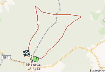


16,8 km | 22 km-effort

Randonnées de Natura 2000 GUIDE+


Application GPS de randonnée GRATUITE
 SityTrail
IGN / Instituts géographiques
SityTrail World
Le monde est à vous
Randonnée Marche de 8,3 km à découvrir à Wallonie, Luxembourg, Manhay. Cette randonnée est proposée par Natura 2000.
La promenade du Sansinri, un affluent de l’Aisne que vous aurez l’occasion de rencontrer, vous emmène à la découverte du site Natura 2000 "Haute Vallée de l’Aisne". Entre forêts résineuses et forêts feuillues, vous passerez des chemins forestiers aux petits sentiers, laissant entrevoir la biodiversité qu’offre ce site. Près de
l’eau, un Martin pêcheur attend patiemment sa proie, perché sur son poste d’affut. Dans les bois, une cigogne noire en quête de
quiétude cherche l’endroit idéal, à la cime d’un arbre, pour y construire son nid.
 "
data-pinterest-text="Pin it"
data-tweet-text="share on twitter"
data-facebook-share-url="https://www.sitytrail.com/fr/trails/337134-manhay--erezee-x-circuit-natura-2000-xdes-sites-qui-valent-le-detourx-x-lx18/?photo=1#lg=1&slide=1"
data-twitter-share-url="https://www.sitytrail.com/fr/trails/337134-manhay--erezee-x-circuit-natura-2000-xdes-sites-qui-valent-le-detourx-x-lx18/?photo=1#lg=1&slide=1"
data-googleplus-share-url="https://www.sitytrail.com/fr/trails/337134-manhay--erezee-x-circuit-natura-2000-xdes-sites-qui-valent-le-detourx-x-lx18/?photo=1#lg=1&slide=1"
data-pinterest-share-url="https://www.sitytrail.com/fr/trails/337134-manhay--erezee-x-circuit-natura-2000-xdes-sites-qui-valent-le-detourx-x-lx18/?photo=1#lg=1&slide=1">
"
data-pinterest-text="Pin it"
data-tweet-text="share on twitter"
data-facebook-share-url="https://www.sitytrail.com/fr/trails/337134-manhay--erezee-x-circuit-natura-2000-xdes-sites-qui-valent-le-detourx-x-lx18/?photo=1#lg=1&slide=1"
data-twitter-share-url="https://www.sitytrail.com/fr/trails/337134-manhay--erezee-x-circuit-natura-2000-xdes-sites-qui-valent-le-detourx-x-lx18/?photo=1#lg=1&slide=1"
data-googleplus-share-url="https://www.sitytrail.com/fr/trails/337134-manhay--erezee-x-circuit-natura-2000-xdes-sites-qui-valent-le-detourx-x-lx18/?photo=1#lg=1&slide=1"
data-pinterest-share-url="https://www.sitytrail.com/fr/trails/337134-manhay--erezee-x-circuit-natura-2000-xdes-sites-qui-valent-le-detourx-x-lx18/?photo=1#lg=1&slide=1">
 "
data-pinterest-text="Pin it"
data-tweet-text="share on twitter"
data-facebook-share-url="https://www.sitytrail.com/fr/trails/337134-manhay--erezee-x-circuit-natura-2000-xdes-sites-qui-valent-le-detourx-x-lx18/?photo=2#lg=1&slide=2"
data-twitter-share-url="https://www.sitytrail.com/fr/trails/337134-manhay--erezee-x-circuit-natura-2000-xdes-sites-qui-valent-le-detourx-x-lx18/?photo=2#lg=1&slide=2"
data-googleplus-share-url="https://www.sitytrail.com/fr/trails/337134-manhay--erezee-x-circuit-natura-2000-xdes-sites-qui-valent-le-detourx-x-lx18/?photo=2#lg=1&slide=2"
data-pinterest-share-url="https://www.sitytrail.com/fr/trails/337134-manhay--erezee-x-circuit-natura-2000-xdes-sites-qui-valent-le-detourx-x-lx18/?photo=2#lg=1&slide=2">
"
data-pinterest-text="Pin it"
data-tweet-text="share on twitter"
data-facebook-share-url="https://www.sitytrail.com/fr/trails/337134-manhay--erezee-x-circuit-natura-2000-xdes-sites-qui-valent-le-detourx-x-lx18/?photo=2#lg=1&slide=2"
data-twitter-share-url="https://www.sitytrail.com/fr/trails/337134-manhay--erezee-x-circuit-natura-2000-xdes-sites-qui-valent-le-detourx-x-lx18/?photo=2#lg=1&slide=2"
data-googleplus-share-url="https://www.sitytrail.com/fr/trails/337134-manhay--erezee-x-circuit-natura-2000-xdes-sites-qui-valent-le-detourx-x-lx18/?photo=2#lg=1&slide=2"
data-pinterest-share-url="https://www.sitytrail.com/fr/trails/337134-manhay--erezee-x-circuit-natura-2000-xdes-sites-qui-valent-le-detourx-x-lx18/?photo=2#lg=1&slide=2">
 "
data-pinterest-text="Pin it"
data-tweet-text="share on twitter"
data-facebook-share-url="https://www.sitytrail.com/fr/trails/337134-manhay--erezee-x-circuit-natura-2000-xdes-sites-qui-valent-le-detourx-x-lx18/?photo=3#lg=1&slide=3"
data-twitter-share-url="https://www.sitytrail.com/fr/trails/337134-manhay--erezee-x-circuit-natura-2000-xdes-sites-qui-valent-le-detourx-x-lx18/?photo=3#lg=1&slide=3"
data-googleplus-share-url="https://www.sitytrail.com/fr/trails/337134-manhay--erezee-x-circuit-natura-2000-xdes-sites-qui-valent-le-detourx-x-lx18/?photo=3#lg=1&slide=3"
data-pinterest-share-url="https://www.sitytrail.com/fr/trails/337134-manhay--erezee-x-circuit-natura-2000-xdes-sites-qui-valent-le-detourx-x-lx18/?photo=3#lg=1&slide=3">
"
data-pinterest-text="Pin it"
data-tweet-text="share on twitter"
data-facebook-share-url="https://www.sitytrail.com/fr/trails/337134-manhay--erezee-x-circuit-natura-2000-xdes-sites-qui-valent-le-detourx-x-lx18/?photo=3#lg=1&slide=3"
data-twitter-share-url="https://www.sitytrail.com/fr/trails/337134-manhay--erezee-x-circuit-natura-2000-xdes-sites-qui-valent-le-detourx-x-lx18/?photo=3#lg=1&slide=3"
data-googleplus-share-url="https://www.sitytrail.com/fr/trails/337134-manhay--erezee-x-circuit-natura-2000-xdes-sites-qui-valent-le-detourx-x-lx18/?photo=3#lg=1&slide=3"
data-pinterest-share-url="https://www.sitytrail.com/fr/trails/337134-manhay--erezee-x-circuit-natura-2000-xdes-sites-qui-valent-le-detourx-x-lx18/?photo=3#lg=1&slide=3">
 "
data-pinterest-text="Pin it"
data-tweet-text="share on twitter"
data-facebook-share-url="https://www.sitytrail.com/fr/trails/337134-manhay--erezee-x-circuit-natura-2000-xdes-sites-qui-valent-le-detourx-x-lx18/?photo=4#lg=1&slide=4"
data-twitter-share-url="https://www.sitytrail.com/fr/trails/337134-manhay--erezee-x-circuit-natura-2000-xdes-sites-qui-valent-le-detourx-x-lx18/?photo=4#lg=1&slide=4"
data-googleplus-share-url="https://www.sitytrail.com/fr/trails/337134-manhay--erezee-x-circuit-natura-2000-xdes-sites-qui-valent-le-detourx-x-lx18/?photo=4#lg=1&slide=4"
data-pinterest-share-url="https://www.sitytrail.com/fr/trails/337134-manhay--erezee-x-circuit-natura-2000-xdes-sites-qui-valent-le-detourx-x-lx18/?photo=4#lg=1&slide=4">
"
data-pinterest-text="Pin it"
data-tweet-text="share on twitter"
data-facebook-share-url="https://www.sitytrail.com/fr/trails/337134-manhay--erezee-x-circuit-natura-2000-xdes-sites-qui-valent-le-detourx-x-lx18/?photo=4#lg=1&slide=4"
data-twitter-share-url="https://www.sitytrail.com/fr/trails/337134-manhay--erezee-x-circuit-natura-2000-xdes-sites-qui-valent-le-detourx-x-lx18/?photo=4#lg=1&slide=4"
data-googleplus-share-url="https://www.sitytrail.com/fr/trails/337134-manhay--erezee-x-circuit-natura-2000-xdes-sites-qui-valent-le-detourx-x-lx18/?photo=4#lg=1&slide=4"
data-pinterest-share-url="https://www.sitytrail.com/fr/trails/337134-manhay--erezee-x-circuit-natura-2000-xdes-sites-qui-valent-le-detourx-x-lx18/?photo=4#lg=1&slide=4">
 "
data-pinterest-text="Pin it"
data-tweet-text="share on twitter"
data-facebook-share-url="https://www.sitytrail.com/fr/trails/337134-manhay--erezee-x-circuit-natura-2000-xdes-sites-qui-valent-le-detourx-x-lx18/?photo=5#lg=1&slide=5"
data-twitter-share-url="https://www.sitytrail.com/fr/trails/337134-manhay--erezee-x-circuit-natura-2000-xdes-sites-qui-valent-le-detourx-x-lx18/?photo=5#lg=1&slide=5"
data-googleplus-share-url="https://www.sitytrail.com/fr/trails/337134-manhay--erezee-x-circuit-natura-2000-xdes-sites-qui-valent-le-detourx-x-lx18/?photo=5#lg=1&slide=5"
data-pinterest-share-url="https://www.sitytrail.com/fr/trails/337134-manhay--erezee-x-circuit-natura-2000-xdes-sites-qui-valent-le-detourx-x-lx18/?photo=5#lg=1&slide=5">
"
data-pinterest-text="Pin it"
data-tweet-text="share on twitter"
data-facebook-share-url="https://www.sitytrail.com/fr/trails/337134-manhay--erezee-x-circuit-natura-2000-xdes-sites-qui-valent-le-detourx-x-lx18/?photo=5#lg=1&slide=5"
data-twitter-share-url="https://www.sitytrail.com/fr/trails/337134-manhay--erezee-x-circuit-natura-2000-xdes-sites-qui-valent-le-detourx-x-lx18/?photo=5#lg=1&slide=5"
data-googleplus-share-url="https://www.sitytrail.com/fr/trails/337134-manhay--erezee-x-circuit-natura-2000-xdes-sites-qui-valent-le-detourx-x-lx18/?photo=5#lg=1&slide=5"
data-pinterest-share-url="https://www.sitytrail.com/fr/trails/337134-manhay--erezee-x-circuit-natura-2000-xdes-sites-qui-valent-le-detourx-x-lx18/?photo=5#lg=1&slide=5">
 "
data-pinterest-text="Pin it"
data-tweet-text="share on twitter"
data-facebook-share-url="https://www.sitytrail.com/fr/trails/337134-manhay--erezee-x-circuit-natura-2000-xdes-sites-qui-valent-le-detourx-x-lx18/?photo=6#lg=1&slide=6"
data-twitter-share-url="https://www.sitytrail.com/fr/trails/337134-manhay--erezee-x-circuit-natura-2000-xdes-sites-qui-valent-le-detourx-x-lx18/?photo=6#lg=1&slide=6"
data-googleplus-share-url="https://www.sitytrail.com/fr/trails/337134-manhay--erezee-x-circuit-natura-2000-xdes-sites-qui-valent-le-detourx-x-lx18/?photo=6#lg=1&slide=6"
data-pinterest-share-url="https://www.sitytrail.com/fr/trails/337134-manhay--erezee-x-circuit-natura-2000-xdes-sites-qui-valent-le-detourx-x-lx18/?photo=6#lg=1&slide=6">
"
data-pinterest-text="Pin it"
data-tweet-text="share on twitter"
data-facebook-share-url="https://www.sitytrail.com/fr/trails/337134-manhay--erezee-x-circuit-natura-2000-xdes-sites-qui-valent-le-detourx-x-lx18/?photo=6#lg=1&slide=6"
data-twitter-share-url="https://www.sitytrail.com/fr/trails/337134-manhay--erezee-x-circuit-natura-2000-xdes-sites-qui-valent-le-detourx-x-lx18/?photo=6#lg=1&slide=6"
data-googleplus-share-url="https://www.sitytrail.com/fr/trails/337134-manhay--erezee-x-circuit-natura-2000-xdes-sites-qui-valent-le-detourx-x-lx18/?photo=6#lg=1&slide=6"
data-pinterest-share-url="https://www.sitytrail.com/fr/trails/337134-manhay--erezee-x-circuit-natura-2000-xdes-sites-qui-valent-le-detourx-x-lx18/?photo=6#lg=1&slide=6">
 "
data-pinterest-text="Pin it"
data-tweet-text="share on twitter"
data-facebook-share-url="https://www.sitytrail.com/fr/trails/337134-manhay--erezee-x-circuit-natura-2000-xdes-sites-qui-valent-le-detourx-x-lx18/?photo=7#lg=1&slide=7"
data-twitter-share-url="https://www.sitytrail.com/fr/trails/337134-manhay--erezee-x-circuit-natura-2000-xdes-sites-qui-valent-le-detourx-x-lx18/?photo=7#lg=1&slide=7"
data-googleplus-share-url="https://www.sitytrail.com/fr/trails/337134-manhay--erezee-x-circuit-natura-2000-xdes-sites-qui-valent-le-detourx-x-lx18/?photo=7#lg=1&slide=7"
data-pinterest-share-url="https://www.sitytrail.com/fr/trails/337134-manhay--erezee-x-circuit-natura-2000-xdes-sites-qui-valent-le-detourx-x-lx18/?photo=7#lg=1&slide=7">
"
data-pinterest-text="Pin it"
data-tweet-text="share on twitter"
data-facebook-share-url="https://www.sitytrail.com/fr/trails/337134-manhay--erezee-x-circuit-natura-2000-xdes-sites-qui-valent-le-detourx-x-lx18/?photo=7#lg=1&slide=7"
data-twitter-share-url="https://www.sitytrail.com/fr/trails/337134-manhay--erezee-x-circuit-natura-2000-xdes-sites-qui-valent-le-detourx-x-lx18/?photo=7#lg=1&slide=7"
data-googleplus-share-url="https://www.sitytrail.com/fr/trails/337134-manhay--erezee-x-circuit-natura-2000-xdes-sites-qui-valent-le-detourx-x-lx18/?photo=7#lg=1&slide=7"
data-pinterest-share-url="https://www.sitytrail.com/fr/trails/337134-manhay--erezee-x-circuit-natura-2000-xdes-sites-qui-valent-le-detourx-x-lx18/?photo=7#lg=1&slide=7">
 "
data-pinterest-text="Pin it"
data-tweet-text="share on twitter"
data-facebook-share-url="https://www.sitytrail.com/fr/trails/337134-manhay--erezee-x-circuit-natura-2000-xdes-sites-qui-valent-le-detourx-x-lx18/?photo=8#lg=1&slide=8"
data-twitter-share-url="https://www.sitytrail.com/fr/trails/337134-manhay--erezee-x-circuit-natura-2000-xdes-sites-qui-valent-le-detourx-x-lx18/?photo=8#lg=1&slide=8"
data-googleplus-share-url="https://www.sitytrail.com/fr/trails/337134-manhay--erezee-x-circuit-natura-2000-xdes-sites-qui-valent-le-detourx-x-lx18/?photo=8#lg=1&slide=8"
data-pinterest-share-url="https://www.sitytrail.com/fr/trails/337134-manhay--erezee-x-circuit-natura-2000-xdes-sites-qui-valent-le-detourx-x-lx18/?photo=8#lg=1&slide=8">
"
data-pinterest-text="Pin it"
data-tweet-text="share on twitter"
data-facebook-share-url="https://www.sitytrail.com/fr/trails/337134-manhay--erezee-x-circuit-natura-2000-xdes-sites-qui-valent-le-detourx-x-lx18/?photo=8#lg=1&slide=8"
data-twitter-share-url="https://www.sitytrail.com/fr/trails/337134-manhay--erezee-x-circuit-natura-2000-xdes-sites-qui-valent-le-detourx-x-lx18/?photo=8#lg=1&slide=8"
data-googleplus-share-url="https://www.sitytrail.com/fr/trails/337134-manhay--erezee-x-circuit-natura-2000-xdes-sites-qui-valent-le-detourx-x-lx18/?photo=8#lg=1&slide=8"
data-pinterest-share-url="https://www.sitytrail.com/fr/trails/337134-manhay--erezee-x-circuit-natura-2000-xdes-sites-qui-valent-le-detourx-x-lx18/?photo=8#lg=1&slide=8">
 "
data-pinterest-text="Pin it"
data-tweet-text="share on twitter"
data-facebook-share-url="https://www.sitytrail.com/fr/trails/337134-manhay--erezee-x-circuit-natura-2000-xdes-sites-qui-valent-le-detourx-x-lx18/?photo=9#lg=1&slide=9"
data-twitter-share-url="https://www.sitytrail.com/fr/trails/337134-manhay--erezee-x-circuit-natura-2000-xdes-sites-qui-valent-le-detourx-x-lx18/?photo=9#lg=1&slide=9"
data-googleplus-share-url="https://www.sitytrail.com/fr/trails/337134-manhay--erezee-x-circuit-natura-2000-xdes-sites-qui-valent-le-detourx-x-lx18/?photo=9#lg=1&slide=9"
data-pinterest-share-url="https://www.sitytrail.com/fr/trails/337134-manhay--erezee-x-circuit-natura-2000-xdes-sites-qui-valent-le-detourx-x-lx18/?photo=9#lg=1&slide=9">
"
data-pinterest-text="Pin it"
data-tweet-text="share on twitter"
data-facebook-share-url="https://www.sitytrail.com/fr/trails/337134-manhay--erezee-x-circuit-natura-2000-xdes-sites-qui-valent-le-detourx-x-lx18/?photo=9#lg=1&slide=9"
data-twitter-share-url="https://www.sitytrail.com/fr/trails/337134-manhay--erezee-x-circuit-natura-2000-xdes-sites-qui-valent-le-detourx-x-lx18/?photo=9#lg=1&slide=9"
data-googleplus-share-url="https://www.sitytrail.com/fr/trails/337134-manhay--erezee-x-circuit-natura-2000-xdes-sites-qui-valent-le-detourx-x-lx18/?photo=9#lg=1&slide=9"
data-pinterest-share-url="https://www.sitytrail.com/fr/trails/337134-manhay--erezee-x-circuit-natura-2000-xdes-sites-qui-valent-le-detourx-x-lx18/?photo=9#lg=1&slide=9">
 "
data-pinterest-text="Pin it"
data-tweet-text="share on twitter"
data-facebook-share-url="https://www.sitytrail.com/fr/trails/337134-manhay--erezee-x-circuit-natura-2000-xdes-sites-qui-valent-le-detourx-x-lx18/?photo=10#lg=1&slide=10"
data-twitter-share-url="https://www.sitytrail.com/fr/trails/337134-manhay--erezee-x-circuit-natura-2000-xdes-sites-qui-valent-le-detourx-x-lx18/?photo=10#lg=1&slide=10"
data-googleplus-share-url="https://www.sitytrail.com/fr/trails/337134-manhay--erezee-x-circuit-natura-2000-xdes-sites-qui-valent-le-detourx-x-lx18/?photo=10#lg=1&slide=10"
data-pinterest-share-url="https://www.sitytrail.com/fr/trails/337134-manhay--erezee-x-circuit-natura-2000-xdes-sites-qui-valent-le-detourx-x-lx18/?photo=10#lg=1&slide=10">
"
data-pinterest-text="Pin it"
data-tweet-text="share on twitter"
data-facebook-share-url="https://www.sitytrail.com/fr/trails/337134-manhay--erezee-x-circuit-natura-2000-xdes-sites-qui-valent-le-detourx-x-lx18/?photo=10#lg=1&slide=10"
data-twitter-share-url="https://www.sitytrail.com/fr/trails/337134-manhay--erezee-x-circuit-natura-2000-xdes-sites-qui-valent-le-detourx-x-lx18/?photo=10#lg=1&slide=10"
data-googleplus-share-url="https://www.sitytrail.com/fr/trails/337134-manhay--erezee-x-circuit-natura-2000-xdes-sites-qui-valent-le-detourx-x-lx18/?photo=10#lg=1&slide=10"
data-pinterest-share-url="https://www.sitytrail.com/fr/trails/337134-manhay--erezee-x-circuit-natura-2000-xdes-sites-qui-valent-le-detourx-x-lx18/?photo=10#lg=1&slide=10">
 "
data-pinterest-text="Pin it"
data-tweet-text="share on twitter"
data-facebook-share-url="https://www.sitytrail.com/fr/trails/337134-manhay--erezee-x-circuit-natura-2000-xdes-sites-qui-valent-le-detourx-x-lx18/?photo=11#lg=1&slide=11"
data-twitter-share-url="https://www.sitytrail.com/fr/trails/337134-manhay--erezee-x-circuit-natura-2000-xdes-sites-qui-valent-le-detourx-x-lx18/?photo=11#lg=1&slide=11"
data-googleplus-share-url="https://www.sitytrail.com/fr/trails/337134-manhay--erezee-x-circuit-natura-2000-xdes-sites-qui-valent-le-detourx-x-lx18/?photo=11#lg=1&slide=11"
data-pinterest-share-url="https://www.sitytrail.com/fr/trails/337134-manhay--erezee-x-circuit-natura-2000-xdes-sites-qui-valent-le-detourx-x-lx18/?photo=11#lg=1&slide=11">
"
data-pinterest-text="Pin it"
data-tweet-text="share on twitter"
data-facebook-share-url="https://www.sitytrail.com/fr/trails/337134-manhay--erezee-x-circuit-natura-2000-xdes-sites-qui-valent-le-detourx-x-lx18/?photo=11#lg=1&slide=11"
data-twitter-share-url="https://www.sitytrail.com/fr/trails/337134-manhay--erezee-x-circuit-natura-2000-xdes-sites-qui-valent-le-detourx-x-lx18/?photo=11#lg=1&slide=11"
data-googleplus-share-url="https://www.sitytrail.com/fr/trails/337134-manhay--erezee-x-circuit-natura-2000-xdes-sites-qui-valent-le-detourx-x-lx18/?photo=11#lg=1&slide=11"
data-pinterest-share-url="https://www.sitytrail.com/fr/trails/337134-manhay--erezee-x-circuit-natura-2000-xdes-sites-qui-valent-le-detourx-x-lx18/?photo=11#lg=1&slide=11">


Marche
Marche

Marche

Marche

V.T.T.
A pied
A pied
magnifique. tout bois
Belle balade à la découverte d'essences de bois differentes. Beaux points de vue et balisage efficace. Je retire une étoile car la majorité de la balade se fait sur chemins forestiers (traces de tracteur ou gravier) ce qui manque parfois de charme.
24/12/17 laarzen met grip nodig.
Excellent !
Mooie wandeling. Bij nat weer laarzen aan te raden