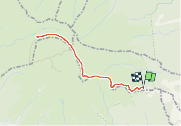
![](/images/other/stat-length.png)
![Randonnée Marche L'Ajoupa-Bouillon - Montagne Pelée Aileron-Refuge2- Caldeira - Photo](https://media.geolcdn.com/t/1900/400/ext.pjpeg?maxdim=2&url=https%3A%2F%2Fstatic1.geolcdn.com%2Fsiteimages%2Fupload%2Ffiles%2F1553511878bg_sport_marche.png)
Montagne Pelée Aileron-Refuge2- Caldeira
ThereseH
Utilisateur
![Longueur](/images/other/stat-length.png)
Longueur
5,9 km
![Altitude max](https://static1.geolcdn.com/siteimages/upload/files/1508320355ic_sort_altitude_max_24dp.png)
Altitude max
1245 m
![Dénivelé positif](https://static1.geolcdn.com/siteimages/upload/files/1508320355ic_sort_den_pos_24dp.png)
Dénivelé positif
485 m
![Km-Effort](/images/other/stat-length.png)
Km-Effort
12,4 km
![Altitude min](https://static1.geolcdn.com/siteimages/upload/files/1508320355ic_sort_altitude_min_24dp.png)
Altitude min
826 m
![Dénivelé négatif](https://static1.geolcdn.com/siteimages/upload/files/1508320355ic_sort_den_neg_24dp.png)
Dénivelé négatif
487 m
![Boucle](https://static1.geolcdn.com/siteimages/upload/files/16400158638029165_repeat_loop_refresh_sync_direction_icon.png)
Boucle
Oui
Date de création :
2022-08-24 12:37:06.078
Dernière modification :
2022-08-25 03:14:37.809
![Marche](https://static1.geolcdn.com/sitytour/trail-icons/101.png)
3h48
Difficulté : Difficile
![Scannez ce code QR pour ouvrir la randonnée dans l'application SityTrail](https://capi.geolives.com/qq0zvz2zws4bq2lad0pu/sitytour/trails/3366753/qr.png?size=200)
Application GPS de randonnée GRATUITE
À propos
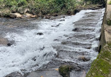
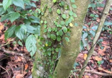
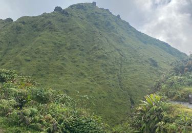
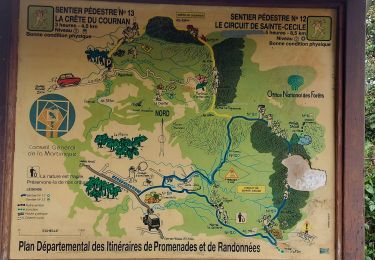
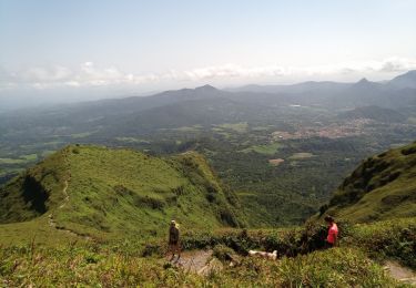
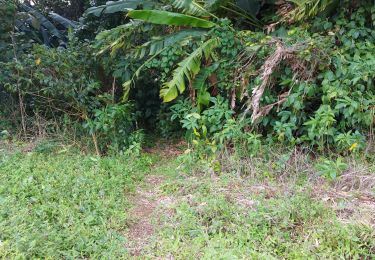
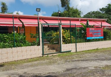
Randonnée Marche de 5,9 km à découvrir à Martinique, Inconnu, L'Ajoupa-Bouillon. Cette randonnée est proposée par ThereseH.
Description
10 personnes prévues puis 4 puis 3
Animateur et 2 adolescents Joachim et Keith du Foyer de l'Espérance Fort de France
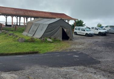
RDV 8h00 Retard : 8h30 Durée prévue 3h00 jusqu'au refuge AR
Localisation
Pays :
France
Région :
Martinique
Département/Province :
Inconnu
Commune :
L'Ajoupa-Bouillon
Localité :
Unknown
Départ:(Dec)
Départ:(UTM)
698942 ; 1637721 (20P) N.
Commentaires
Randonnées à proximité
![Randonnée Marche Le Morne-Rouge - Mac Intoch - Morne Capot - Photo](https://media.geolcdn.com/t/375/260/ext.jpg?maxdim=2&url=https%3A%2F%2Fstatic1.geolcdn.com%2Fsiteimages%2Fupload%2Ffiles%2F1553511878bg_sport_marche.png)
![Marche Marche](https://static1.geolcdn.com/sitytour/trail-icons/101.png)
Mac Intoch - Morne Capot
Marche
Moyen
(1)
Le Morne-Rouge,
Martinique,
Inconnu,
France
![](/images/other/stat-length.png)
9,4 km | 14,9 km-effort
4h 53min
![](https://static1.geolcdn.com/siteimages/upload/files/16400158638029165_repeat_loop_refresh_sync_direction_icon.png)
Non
![Randonnée Marche L'Ajoupa-Bouillon - Montagne pelée - Photo](https://media.geolcdn.com/t/375/260/ext.jpg?maxdim=2&url=https%3A%2F%2Fmedia.geolcdn.com%2Ff%2F4661306f-959d-4727-8469-834deb4937e3.jpg)
![Marche Marche](https://static1.geolcdn.com/sitytour/trail-icons/101.png)
Montagne pelée
Marche
Difficile
L'Ajoupa-Bouillon,
Martinique,
Inconnu,
France
![](/images/other/stat-length.png)
7,5 km | 16,5 km-effort
6h 2min
![](https://static1.geolcdn.com/siteimages/upload/files/16400158638029165_repeat_loop_refresh_sync_direction_icon.png)
Oui
![Randonnée Marche L'Ajoupa-Bouillon - Défi 2022 étoile - Photo](https://media.geolcdn.com/t/375/260/ext.jpg?maxdim=2&url=https%3A%2F%2Fmedia.geolcdn.com%2Ff%2F29eb6e31-eab8-4976-9d5e-4e2a469a4b37.jpg)
![Marche Marche](https://static1.geolcdn.com/sitytour/trail-icons/101.png)
Défi 2022 étoile
Marche
L'Ajoupa-Bouillon,
Martinique,
Inconnu,
France
![](/images/other/stat-length.png)
9,1 km | 15,6 km-effort
3h 33min
![](https://static1.geolcdn.com/siteimages/upload/files/16400158638029165_repeat_loop_refresh_sync_direction_icon.png)
Non
![Randonnée Marche Le Morne-Rouge - Crête du Cournan boucle - Photo](https://media.geolcdn.com/t/375/260/ext.jpg?maxdim=2&url=https%3A%2F%2Fmedia.geolcdn.com%2Ff%2F0c296f5b-819e-48af-b83c-d8f8f993e809.jpg)
![Marche Marche](https://static1.geolcdn.com/sitytour/trail-icons/101.png)
Crête du Cournan boucle
Marche
Moyen
Le Morne-Rouge,
Martinique,
Inconnu,
France
![](/images/other/stat-length.png)
4,2 km | 8,2 km-effort
2h 15min
![](https://static1.geolcdn.com/siteimages/upload/files/16400158638029165_repeat_loop_refresh_sync_direction_icon.png)
Oui
![Randonnée Marche L'Ajoupa-Bouillon - Montagne Pelée - Photo](https://media.geolcdn.com/t/375/260/ext.jpg?maxdim=2&url=https%3A%2F%2Fmedia.geolcdn.com%2Ff%2F6be9e0ce-140a-493e-bd2e-864a18d26510.jpg)
![Marche Marche](https://static1.geolcdn.com/sitytour/trail-icons/101.png)
Montagne Pelée
Marche
Moyen
L'Ajoupa-Bouillon,
Martinique,
Inconnu,
France
![](/images/other/stat-length.png)
7,8 km | 16,8 km-effort
4h 49min
![](https://static1.geolcdn.com/siteimages/upload/files/16400158638029165_repeat_loop_refresh_sync_direction_icon.png)
Oui
![Randonnée Marche Le Morne-Rouge - Domaine de la vallée via Hbt Pecoul - Photo](https://media.geolcdn.com/t/375/260/ext.jpg?maxdim=2&url=https%3A%2F%2Fmedia.geolcdn.com%2Ff%2F54663b6c-bb90-4c0c-992c-e11eeec283a2.jpg)
![Marche Marche](https://static1.geolcdn.com/sitytour/trail-icons/101.png)
Domaine de la vallée via Hbt Pecoul
Marche
Difficile
Le Morne-Rouge,
Martinique,
Inconnu,
France
![](/images/other/stat-length.png)
15,6 km | 26 km-effort
6h 0min
![](https://static1.geolcdn.com/siteimages/upload/files/16400158638029165_repeat_loop_refresh_sync_direction_icon.png)
Non
![Randonnée Marche L'Ajoupa-Bouillon - Refuge Aileron - Gorges de La Falaise - Photo](https://media.geolcdn.com/t/375/260/ext.jpg?maxdim=2&url=https%3A%2F%2Fmedia.geolcdn.com%2Ff%2F9c0b2fb5-844c-461f-bc74-de900a49e109.jpg)
![Marche Marche](https://static1.geolcdn.com/sitytour/trail-icons/101.png)
Refuge Aileron - Gorges de La Falaise
Marche
Facile
L'Ajoupa-Bouillon,
Martinique,
Inconnu,
France
![](/images/other/stat-length.png)
3,7 km | 5,1 km-effort
1h 10min
![](https://static1.geolcdn.com/siteimages/upload/files/16400158638029165_repeat_loop_refresh_sync_direction_icon.png)
Non
![Randonnée Marche L'Ajoupa-Bouillon - Gorges de la Falaise - 1er Refuge Pele - Photo](https://media.geolcdn.com/t/375/260/ext.jpg?maxdim=2&url=https%3A%2F%2Fmedia.geolcdn.com%2Ff%2F39f4792d-d93d-4ffa-9305-1dc0390ddf75.jpg)
![Marche Marche](https://static1.geolcdn.com/sitytour/trail-icons/101.png)
Gorges de la Falaise - 1er Refuge Pele
Marche
Moyen
L'Ajoupa-Bouillon,
Martinique,
Inconnu,
France
![](/images/other/stat-length.png)
3,5 km | 7,5 km-effort
1h 0min
![](https://static1.geolcdn.com/siteimages/upload/files/16400158638029165_repeat_loop_refresh_sync_direction_icon.png)
Non
![Randonnée Marche L'Ajoupa-Bouillon - Ajoupa bouillon - Photo](https://media.geolcdn.com/t/375/260/ext.jpg?maxdim=2&url=https%3A%2F%2Fmedia.geolcdn.com%2Ff%2F783a97d0-7755-471d-95b3-ff56e0b20050.jpg)
![Marche Marche](https://static1.geolcdn.com/sitytour/trail-icons/101.png)
Ajoupa bouillon
Marche
Très difficile
L'Ajoupa-Bouillon,
Martinique,
Inconnu,
France
![](/images/other/stat-length.png)
14,7 km | 26 km-effort
4h 16min
![](https://static1.geolcdn.com/siteimages/upload/files/16400158638029165_repeat_loop_refresh_sync_direction_icon.png)
Oui